Adelgade

Last updated
Adelgade
Kopengagen - panoramio (4).jpg
The easternmost end of the street with St. Paul's Church
Length345 m (1,132 ft)
Location Indre By, Copenhagen, Denmark
Postal code1304
Coordinates 55°41′6.72″N12°35′4.92″E / 55.6852000°N 12.5847000°E / 55.6852000; 12.5847000

Adelgade (lit. "Nobility Street") is a street in central Copenhagen, Denmark. It runs from Gothersgade in the south to Sankt Pauls Plads with St. Paul's Church in the north. The first half of the street is dominated by modern buildings while its last section passes through the Nyboder district.

Contents

History

Adelgade originates in the 1649 plan for New Copenhagen, the large area which was included in the fortified city when the old East Rampart along present day Gothersgade was decommissioned and a new one was built in a more northerly direction. According to the plan, the streets in the area were to be named after Danish territorial possessions, royalty and the upper classes. [1] The new district was spaciously planned with long straight streets. The most affluent families settled along Bredgade and Ny Kongensgade while the area around Adelgade and Borgergade catered to a more modest clientele, typically craftsmen and shop-keepers. The buildings were generally half-timbered and relatively small, and living conditions were still considerably better than in the crowded city centre.

Christian Gedde's 1757 map of St. Ann's West Quarter: Borgergade is the horizontal street in the bottom of the map Sankt Annae vester kvarter (1757).jpg
Christian Gedde's 1757 map of St. Ann's West Quarter: Borgergade is the horizontal street in the bottom of the map

The neighbourhood escaped both the fire of 1728 and 1795, and was also left largely unharmed by the British bombardment of the city during the Battle of Copenhagen in 1807. While Adelgade escaped the direct effects fires and war, they would still have a deep impact on the street. Many people who had been left homeless and ruined by the disasters moved there in search of affordable accommodation, making it increasingly crowded. Gardens and courtyards were built over and extra floors were added on top of existing buildings to make room for the many new residents.

On 26 January 1865, the first public bath house opened in the street after a donation from Carl Joachim Hambro, a banker residing in London, [2] but apart from that sanitation facilities were sparse. [3]

When the Fortifications were decommissioned in the middle of the century, many of the owners moved on to the new residential districts which had sprung up, such as Nørrebro and Vesterbro, and the area around Borgergade developed into one of the worst and most crowded slums in the city with a notorious reputation for poverty, vice and crime.

In the end, it was decided to condemn the area. Clearing began in the early 1940s but was put on hold in 1943 due to the war. After the Liberation, the work was resumed and the area was built up with modern buildings in the late 1940s and 50s. Two smaller streets, Prinsessegade and Helsingørgade, ceased to exist.

Notable buildings and residents

Turbinehallerne Turbinehallerne, Copenhagen.jpg
Turbinehallerne

Turbinehallen (No. 10) is the only surviving part of Gothersgade Power Plant. The building is from 1900 and was designed by Fritz Koch. It was adapted for use as a modern stage for the Royal Danish Theatre by Erik Møller Arkitekter in 1989 and was used as such until the inauguration of the Royal Danish Playhouse on the harbourfront. It is now used as a conference and event venue. [4]

The 600-bed Generator Hostel Copenhagen (No. 57), on the other side of the street, opened in a former 1960s office building in 2011. It features a 700 square metre roof terrace. [5]

Borgergarden Adelgade - Borgergarden.jpg
Borgergården

The most striking modern development along the street is Dronningegården which forms an urban space around the intersection of Adelgade with Dronningens Tværgade. The housing estate was designed by Kay Fisker. [6]

The far end of Adelgade with St Paul's Church and Nyboder houses Adelgade - church.jpg
The far end of Adelgade with St Paul's Church and Nyboder houses

Borgergården (No. 5064) is from 1960 and was designed by Thorvald Dreyer an Svend Eske Kristensen.d

The last section of Adelgade passes four rows of Nyboder houses, two on each side of the street, oriented along Fredericiagade and Olfert Fischer Gade respectively.

See also

Related Research Articles

<span class="mw-page-title-main">Fortifications of Copenhagen (17th century)</span>

The fortifications of Copenhagen underwent a comprehensive modernization and expansion in the 17th century. The project was commenced and was largely the masterplan of Christian IV in the early 17th century but was continued and completed by his successors. The new fortifications relied on the existing, medieval fortifications of the city but the fortified area was extended and a defensive ring around the city completed particularly with new edifices facing the sea. The ring fortification consisted of four bastioned ramparts and an annexed citadel as well as various outworks.

<span class="mw-page-title-main">Gothersgade</span> Street in Copenhagen, Denmark

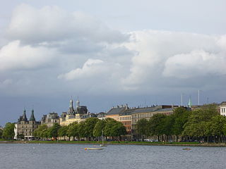
Gothersgade is a major street in the City Centre of Copenhagen, Denmark. It extends from Kongens Nytorv to Sortedam Lake, passing Rosenborg Castle and Gardens, Nørreport Station and Copenhagen Botanic Gardens on the way.

<span class="mw-page-title-main">St. Paul's Church, Copenhagen</span> Church in Copenhagen, Denmark

St. Paul's Church is a Lutheran church in central Copenhagen, Denmark, also colloquially known as Nyboder's Church due to its location in the middle of the Nyboder area. It was designed by Johannes Emil Gnudtzmann and constructed from 1872 to 1877.

<span class="mw-page-title-main">Nørre Voldgade</span> Street in Copenhagen, Denmark

Nørre Voldgade is a street in central Copenhagen, Denmark. It runs north-east from Jarmers Plads for approximately 600 metres to Gothersgade where it turns into Øster Voldgade. The succession of Nørre Voldgade, Øster Voldgade and Vester Voldgade together forms a traffic artery which arches around the Zealand side of the central and oldest part of Copenhagen. Nørreport Station, Denmark's busiest railway station, is located in the street.

<span class="mw-page-title-main">Kronprinsessegade</span> Street in Copenhagen, Denmark

Kronprinsessegade is a street in central Copenhagen, Denmark. Noted for its fine Neoclassical houses, it extends from Gothersgade and runs along the southern boundary of Rosenborg Castle Garden, passing Sølvgade and the Nyboder district of old naval barracks before finally joining Øster Voldgade close to Østerport Station. The David Collection, a museum which displays a large collection of Islamic art as well as Danish and European fine and applied arts, is based at No. 30.

<span class="mw-page-title-main">Borgergade</span> Street in Copenhagen, Denmark

Borgergade is a street in central Copenhagen, Denmark. It runs from Gothersgade to Store Kongensgade. As one of relatively few streets in central Copenhagen, the street, in its western part, is dominated by modern buildings. The eastern part passes through the Nyboder district.

<span class="mw-page-title-main">Gammel Mønt</span>

Gammel Mønt is a street in central Copenhagen, Denmark, located one block west of Gothersgade and Rosenborg Castle Garden.

<span class="mw-page-title-main">Dronningens Tværgade</span> Street in Copenhagen, Denmark

Dronningens Tværgade is a street in central Copenhagen, Denmark, which runs from Bredgade to Rosenborg Castle Garden. The street originally formed a link between the King's Garden and the Queen's Garden. With the Odd Fellows Mansion on Bredgade and the central pavilions of the east fringe of the castle garden located at each their end, the street has axial qualities. These are accentuated by the Dronningegården Estate, a Functionalist housing complex from the 1940s, which forms an urban space around the intersection with Adelgade.

<span class="mw-page-title-main">Toldbodgade</span> Street in Copenhagen, Denmark

Toldbodgade is a street in central Copenhagen, Denmark. It extends north from Nyhavn at the Nyhavn Bridge, continuing Holberggade, passes Sankt Annæ Plads after just one block, and continues straight until it reaches West India Warehouse where it makes a sharp left turn which connects it to Amaliegade, its parallel street, at the rear of the Design Museum.

<span class="mw-page-title-main">Sølvgade</span> Street in Copenhagen, Denmark

Sølvgade is a street in central Copenhagen, Denmark, extending north-west from Borgergade to The Lakes where Fredens Bro connects it to Fredensgade. The section from Kronprinsessegade to Øster Voldgade follows the walled north-eastern margin of Rosenborg Castle Garden and the next section, from Øster Voldgade to the intersection with Farimagsgade, named Sølvtorvet although it is little more than a busy street junction, separates Copenhagen Botanical Garden from Østre Anlæg.

<span class="mw-page-title-main">New Copenhagen</span> 17th-century expansion of Copenhagen, Denmark

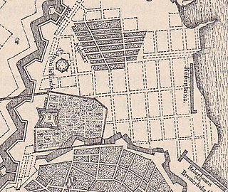
New Copenhagen or St. Ann's Town was a 17th-century expansion of fortified Copenhagen, Denmark.

<span class="mw-page-title-main">Nansensgade</span> Street in Copenhagen Municipality, Denmark

Nansensgade is a street in central Copenhagen, Denmark, linking Gyldenløvesgade in the southwest with Gothersgade in the northeast. The street is known for its abundance of cafés and trendy shops, and plays host to an annual street festival. Charlotte Ammundsens Plads, located in front of the local community centre, is an urban space which connects Nansensgade to Nørre Søgade

<span class="mw-page-title-main">Landemærket</span>

Landemærket, literally "The Landmark", is a street in the Old Town of Copenhagen, Denmark. It extends from Købmagergade along the north side of the Trinitatis Complex (Round Tower and Trinitatis Church, Guttenberghus and the Film House to Gothersgade at Rosenborg Castle Gardens.

<span class="mw-page-title-main">Grønnegade</span>

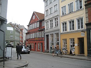
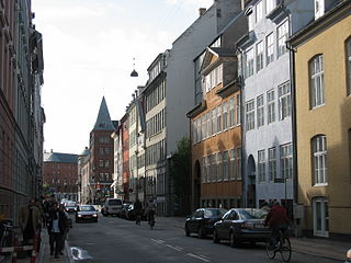
Grønnegade is a street in the Old Town of Copenhagen, Denmark, running northeast from Gammel Mønt to Gothersgade where it turns into Borgergade. It is part of Copenhagen's most exclusive shopping area, located northwest of Kongens Nytorv.

<span class="mw-page-title-main">Søgade, Copenhagen</span>

Vester, Nørre and Øster Søgade is a succession of streets along the eastern side of The Lakes in central Copenhagen, Denmark. The streets run from Gammel Kongevej to the south to the beginning of Østerbrogade at Lille Trianglen in the north. Vester Søgade runs from Gammel Kongevej to Gyldenløvesgade, Nørre Søgade runs from Gyldenløvesgade to Dronning Louises Bro, and Øster Søgade from Dronning Louises Bro to Lille Triangel.

<span class="mw-page-title-main">Klerkegade</span>

Klerkegade is a street in central Copenhagen, Denmark. The street runs from Borgergade in the east to Rigensgade in the west, passing Adelgade and Kronprinsessegade on the way.

<span class="mw-page-title-main">Møntergade</span>

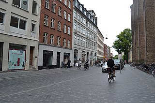
Møntergade is a street in the Old Town of Copenhagen, Denmark. It runs from Pilestræde in the west to Gothersgade in the east.

<span class="mw-page-title-main">Rigensgade</span> Street in Copenhagen, Denmark

Rigensgade is a street in central Copenhagen, Denmark. It links Sølvgade in the west with Øster Voldgade in the east. An underpass for pedestrians link the beginning of the street with Rosenborg Castle Gardens on the other side of Sølvgade. Notable buildings include the former Garrison Hospital. and the Methodist Jerusalem's Church.

<span class="mw-page-title-main">Åbenrå (street)</span> Street in Copenhagen, Denmark

Åbenrå is a street in the Old Town of Copenhagen, Denmark. It runs from Landemærket in the southeast to Rosenborggade in the northwest, linking Vognmagergade with Tornebuskgade. The last part of the street passes the rear side of the grounds of the Reformed Church in Gothersgade. The former rectory associated with the church is located at No. 32-36. It is now houses the Danish Association of Architects.

<span class="mw-page-title-main">Olfert Fischers Gade</span> Street in Copenhagen, Denmark

Olfert Fischers Gade is a street in the Nyboder Quarter of central Copenhagen, Denmark and is named after the naval officer Olfert Fischer who commanded the Danish fleet in the Battle of Copenhagen in 1801. It runs from Store Kongensgade in the east to Rigensgade in the west, intersecting the streets Borgergade, Adelgade/Sankt Pauls Plads, Gammelvagt and Kronprinsessegade on the way. The street is closed to through traffic on the west side of Borgergade.

References

  1. "Adelgade" (in Danish). Selskabet for Københavns Historie. Archived from the original on 2014-10-16. Retrieved 2014-10-13.
  2. "Badeanstalt i Borgergade". Museum of Copenhagen. Archived from the original on 2012-04-07. Retrieved 2011-09-28.
  3. "Borgergade" (in Danish). Selskabet for Københavns Historie. Archived from the original on 2012-04-06. Retrieved 2011-09-28.
  4. "Turbinehallen" (in Danish). Turbinehallen. Archived from the original on 2014-10-18. Retrieved 2014-10-14.
  5. "Trendy hostel skal lokke unge til København" (in Danish). check-in.dk. Retrieved 2014-10-15.
  6. "Gasværket". AOK. Archived from the original on 2009-12-21. Retrieved 2010-01-04.

55°41′07″N12°35′05″E / 55.6852°N 12.5847°E / 55.6852; 12.5847