Coastal Andhra or Kosta Andhra is a geographic region in the States and union territories of India of Andhra Pradesh. Vijayawada is the largest city in this region. Region share borders with Uttarandhra, Rayalaseema and Telangana. It was part of Madras State before 1953 and Andhra State from 1953 to 1956. According to the 2011 census, it has an area of 91,915 square kilometres (35,489 sq mi) which is 57.99% of the total state area and a population of 34,193,868 which is 69.20% of Andhra Pradesh state population. This area includes the coastal districts of Andhra Pradesh on the Circar Coast between the Eastern Ghats and the Bay of Bengal, from the northern border with Odisha to Rayalaseema in the south.

Amaravathi is a village on the banks of the Krishna River, in the Palnadu district of the Indian state of Andhra Pradesh. It is the headquarters of Amaravathi mandal, and forms part of the Andhra Pradesh Capital Region with its headquarters at new Amaravati 35 km (22 mi) east, whose name is also borrowed from that of the older Amaravathi.

Shravasti ; Pali: 𑀲𑀸𑀯𑀢𑁆𑀣𑀻, romanized: Sāvatthī) is a town in Shravasti district in Indian State of Uttar Pradesh. It was the capital of the ancient Indian kingdom of Kosala and the place where the Buddha lived most after his enlightenment. It is near the Rapti river in the northeastern part of Uttar Pradesh India, close to the Nepalese border.

Ghantasala is a village in Krishna district of the Indian state of Andhra Pradesh. It is 21 km west of Machilipatnam and 11 km east of Krishna River. The largest city of this district, Vijayawada, is around 60 km away. It is a rare and reputed center for Buddhist sculptures. Kaṇṭakasola was the ancient name of Ghantasala. It was also mentioned by Ptolemy as Kantakossyla.
Telugu people, also called Andhras, are an ethno-linguistic group who speak the Telugu language and are native to the Indian states of Andhra Pradesh, Telangana and Yanam district of Puducherry. They are the most populous of the four major Dravidian groups. Telugu is the fourth most spoken language in India and the 14th most spoken native language in the world. A significant number of Telugus also reside in the Indian states of Karnataka, Tamil Nadu, Orissa, Maharashtra. Members of the Telugu diaspora are spread across countries like United States, Australia, Malaysia, Mauritius, UAE, and others. By 2024 Telugu is spoken by 95.7 million people all over world, which makes it the third largest Indian diaspora after Hindi and Bengali. Telugu is the fastest-growing language in the United States. It is also a protected language in South Africa.

Ramateertham is a village panchayat in Nellimarla mandal of Vizianagaram district in Andhra Pradesh in India. It is about 12 km from Vizianagaram city. It is a famous Pilgrimage and also Ancient Historical Site since 3rd Century BCE. There is a post office at Ramateertham. The PIN code is 535218.
Pauni is a town and a Municipal Council in Bhandara district in the Indian state of Maharashtra. Now it has National Highway NH-247. Pauni is also known as Kashi of Vidarbha due to its wide swath of temples.

Nagarjunakonda: Nāgārjunikoṇḍa, meaning Nagarjuna Hill) is a historical town, now an island located near Nagarjuna Sagar in Palnadu district of the Indian state of Andhra Pradesh. It is one of India's richest Buddhist sites, and now lies almost entirely under the lake created by the Nagarjuna Sagar Dam. With the construction of the dam, the archaeological relics at Nagarjunakonda were submerged, and had to be excavated and transferred to higher land, which has become an island.

The Dharmarajika Stupa, also referred to as the Great Stupa of Taxila, is a Buddhist stupa near Taxila, Pakistan. It was built over the relics of the Buddha by Ashoka in the 3rd century BCE. The stupa, along with the large monastic complex that later developed around it, forms part of the Ruins of Taxila - which were inscribed as a UNESCO World Heritage Site in 1980.

Salihundam, is a village and panchayat in Gara Mandal of Srikakulam district in Andhra Pradesh. It is a historically important Buddhist monument of ancient Kalinga and a major tourist attraction It is a village lying on top of the hill on the south bank of the Vamsadhara River. It is at a distance of 5 KM west to Kalingapatnam and 10 KM from Singupuram and 18 KM from Srikakulam town. It was known as Salipetaka.

Pushpagiri was an ancient Indian mahavihara or monastic complex located atop Langudi Hill in Jajpur district of Odisha, India. Pushpagiri was mentioned in the writings of the Chinese traveller Xuanzang and some other ancient sources. Until the 1990s, it was hypothesised to be one or all of the Lalitgiri-Ratnagiri-Udayagiri group of monastic sites, also located in Jajpur district. These sites contain ruins of many buildings, stupas of various sizes, sculptures, and other artifacts.

Nelakondapally, also referred to as Nelakondapalli or Nela Kondapalli, is a town and headquarters of a mandal in Khammam district, Telangana, India. It is also an archaeological site important to early Buddhism and Hinduism, where excavations have discovered a major stupa site near an ancient manmade lake, another site where Buddhist and Hindu artwork were carved in pre-3rd century India, both sites also yielding hundreds of ancient rare coins with Shaiva and Vaishnava inscriptions from the dynasties of Andhra Ikshvakus and Vishnukundinas. Nelakondapally is also the birthplace of Bhakta Ramadasu.

Uttar Pradesh, a state in north India has a long association with Jainism. Today the state is home to a number of Jain monuments, such as Jain Temples and Jain Tirths. There are around 213,267 Jains in Uttar Pradesh according to 2011 Census of India.
Pavurallakonda or Pavurallabodu is the local name of the hill popularly known as Narasimhaswamy Konda, near Bheemunipatnam about 25km north of Visakhapatnam, in the Indian state of Andhra Pradesh. It is located at a height of about 150 meters above sea level.

Adilabad district is a district located in the northern region of Telangana, India. It is known as the gateway district to South and Central India. The town of Adilabad is its headquarters. The district shares boundaries with Asifabad, Nirmal districts and with the state boundary of Maharashtra.

The Guntupalle or Guntupalli Group of Buddhist Monuments is located near Kamavarapukota, Eluru district, in the state of Andhra Pradesh in India. It is around 40 km away from Eluru. The rock-cut part of the site has two Buddhist caves, a chaitya hall and a large group of stupas. The chaitya hall has a rare carved stone entrance replicating wooden architecture, a simpler version of that at the Lomas Rishi Cave.
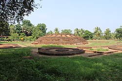
Amarāvati Stupa is a ruined Buddhist stūpa at the village of Amaravathi, Palnadu district, Andhra Pradesh, India, probably built in phases between the third century BCE and about 250 CE. It was enlarged and new sculptures replaced the earlier ones, beginning in about 50 CE. The site is under the protection of the Archaeological Survey of India, and includes the stūpa itself and the Archaeological Museum.

Chandavaram Buddhist site is an ancient Indian Buddhist site in Chandavaram village in Prakasam district in the Indian state of Andhra Pradesh. Situated on the bank of Gundlakamma River, the site is 10 kilometres (6.2 mi) northwest of Donakonda railway station. The Chandavaram Buddhist site was built between the 2nd century BCE and the 2nd century CE during the Satavahana dynasty and was discovered by Veluri Venkata Krishna Sastry in 1964.

Ancient Indian architecture ranges from the Indian Bronze Age to around 800 CE. By this endpoint Buddhism in India had greatly declined, and Hinduism was predominant, and religious and secular building styles had taken on forms, with great regional variation, which they largely retain even after some forceful changes brought about by the arrival of first Islam, and then Europeans.

Konaseema district, is one of the 26 districts in the Indian state of Andhra Pradesh. It is situated between the tributaries of the Godavari River in the Konaseema region of Coastal Andhra. It was carved out of East Godavari district on 4 April 2022 by the Government of Andhra Pradesh. Amalapuram is the district headquarters and the largest city in this district. The district shares boundaries with West Godavari, East Godavari and Kakinada districts.