The Iron Age is the final epoch of the three-age division of the prehistory and protohistory of humanity. It was preceded by the Stone Age and the Bronze Age. The concept has been mostly applied to Europe and the Ancient Near East, but also, by analogy, to other parts of the Old World.

Infrared (IR), sometimes called infrared light, is electromagnetic radiation (EMR) with wavelengths longer than those of visible light. It is therefore invisible to the human eye. IR is generally understood to encompass wavelengths from around 1 millimeter (300 GHz) to the nominal red edge of the visible spectrum, around 700 nanometers (430 THz). Longer IR wavelengths (30μm-100μm) are sometimes included as part of the terahertz radiation range. Almost all black-body radiation from objects near room temperature is at infrared wavelengths. As a form of electromagnetic radiation, IR propagates energy and momentum, with properties corresponding to both those of a wave and of a particle, the photon.

The Middle East is a geopolitical term that commonly refers to the region spanning the Levant, Arabian Peninsula, Anatolia, Egypt, Iran and Iraq. The term came into widespread usage as a replacement of the term Near East beginning in the early 20th century. The term "Middle East" has led to some confusion over its changing definitions, and has been viewed by some to be discriminatory or too Eurocentric. The region includes the vast majority of the territories included in the closely associated definition of Western Asia, but without the Caucasus and including all of Egypt, and not just the Sinai Peninsula.

A near-Earth object (NEO) is any small Solar System body whose orbit brings it into proximity with Earth. By convention, a Solar System body is a NEO if its closest approach to the Sun (perihelion) is less than 1.3 astronomical units (AU). If a NEO's orbit crosses the Earth's, and the object is larger than 140 meters (460 ft) across, it is considered a potentially hazardous object (PHO). Most known PHOs and NEOs are asteroids, but a small fraction are comets.

The Rocky Mountains, also known as the Rockies, are a major mountain range and the largest mountain system in North America. The Rocky Mountains stretch 3,000 mi (4,800 km) in straight-line distance from the northernmost part of western Canada, to New Mexico in the southwestern United States. Depending on differing definitions between Canada and the United States, its northern terminus is located either in northern British Columbia's Terminal Range south of the Liard River and east of the Trench, or in the northeastern foothills of the Brooks Range/British Mountains that face the Beaufort Sea coasts between the Canning River and the Firth River across the Alaska-Yukon border. Its southernmost point is near the Albuquerque area adjacent to the Rio Grande Basin and north of the Sandia–Manzano Mountain Range. Being the easternmost portion of the North American Cordillera, the Rockies are distinct from the tectonically younger Cascade Range and Sierra Nevada, which both lie farther to its west.

South East England is one of the nine official regions of England at the first level of ITL for statistical purposes. It consists of the counties of Buckinghamshire, East Sussex, Hampshire, the Isle of Wight, Kent, Oxfordshire, Berkshire, Surrey and West Sussex. Major towns and cities in the region include Brighton and Hove, Milton Keynes, Southampton, Portsmouth, Slough, Reading and Oxford.

The Tisza, Tysa or Tisa, is one of the major rivers of Central and Eastern Europe. Once, it was called "the most Hungarian river" because it flowed entirely within the Kingdom of Hungary. Today, it crosses several national borders.

The Appalachian National Scenic Trail, generally known as the Appalachian Trail or simply the A.T., is a marked hiking trail in the Eastern United States extending between Springer Mountain in Georgia and Mount Katahdin in Maine. The trail passes through 14 states and is about 2,200 miles (3,500 km) long, though the exact length changes over time as parts are rerouted or modified. The Appalachian Trail Conservancy describes the Appalachian Trail as the longest hiking-only trail in the world. More than two million people are said to take a hike on part of the trail at least once each year.

The International Union for Conservation of Nature (IUCN) Red List of Threatened Species, founded in 1964, is the world's most comprehensive inventory of the global conservation status of biological species. It uses a set of precise criteria to evaluate the extinction risk of thousands of species and subspecies. These criteria are relevant to all species and all regions of the world. With its strong scientific base, the IUCN Red List is recognized as the most authoritative guide to the status of biological diversity. A series of Regional Red Lists are produced by countries or organizations, which assess the risk of extinction to species within a political management unit.

The Near East is a geographical term which roughly encompasses a transcontinental region in Western Asia, that was once the historical Fertile Crescent, and later the Levant section of the Roman and Byzantine empires. It comprises Turkey, and Egypt. Despite having varying definitions within different academic circles, the term was originally applied to the maximum extent of the Ottoman Empire.
A front vowel is a class of vowel sounds used in some spoken languages, its defining characteristic being that the highest point of the tongue is positioned as far forward as possible in the mouth without creating a constriction that would otherwise make it a consonant. Front vowels are sometimes also called bright vowels because they are perceived as sounding brighter than the back vowels.

A near-threatened species is a species which has been categorized as "Near Threatened" (NT) by the International Union for Conservation of Nature as that may be vulnerable to endangerment in the near future, but it does not currently qualify for the threatened status.

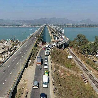
National Highway 16 is a major National Highway in India, that runs along east coast of West Bengal, Odisha, Andhra Pradesh and Tamil Nadu. It was previously known as National Highway 5.
A near-death experience (NDE) is a profound personal experience associated with death or impending death which researchers claim share similar characteristics. When positive, such experiences may encompass a variety of sensations including detachment from the body, feelings of levitation, total serenity, security, warmth, the experience of absolute dissolution, and the presence of a light. When negative, such experiences may include sensations of anguish and distress.

The ancient Near East was the home of early civilizations within a region roughly corresponding to the modern Middle East: Mesopotamia, ancient Egypt, ancient Iran, Anatolia/Asia Minor and the Armenian Highlands, the Levant, Cyprus and the Arabian Peninsula. The ancient Near East is studied in the fields of Ancient Near East studies, Near Eastern archaeology and ancient history.
National Highway 27, an East - West National highway in India that starts in Porbandar and ends in Silchar, the highway passes through the states of Gujarat, Rajasthan, Madhya Pradesh, Uttar Pradesh, Bihar, West Bengal, Assam. NH-27 was laid and is maintained by Ministry of Road Transport and Highways (MoRTH). It is the second longest National Highway in India and is a part of NS-EW Corridor of NHAI.

National Highway 19 is a national highway in India. It was previously referred to as Delhi–Kolkata Road and is one of the busiest national highways in India. After renumbering of national highways, Delhi to Agra route is now national highway 44 and Agra to Kolkata route is numbered national highway 19. It constitutes a major portion of the historical Grand Trunk Road. It is also part of AH1 of Asian Highway Network, that traverses from Japan to Turkey.
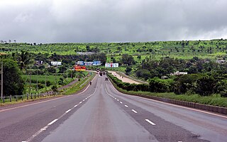
National Highway 48 is a National Highway of India that starts at Delhi and terminates at Chennai traversing through seven states of India. It has a total length of 2807 km. NH 48 passes through the states of Delhi, Haryana, Rajasthan, Gujarat, Maharashtra, Karnataka and Tamil Nadu.
