Related Research Articles

Pashtunistan is a historical region located on the Iranian Plateau, inhabited by the indigenous Pashtun people of southern Afghanistan and northwestern Pakistan in South-Central Asia, wherein Pashtun culture, the Pashto language, and Pashtun identity have been based. Alternative names historically used for the region include Pashtūnkhwā (پښتونخوا), Pakhtūnistān, Pathānistān, or simply the Pashtun Belt. Pashtunistan borders the geographical regions of Turkestan to the north, Kashmir to the northeast, Punjab to the east, Balochistan to the south and Iran to the west.

The Durand Line, forms the Afghanistan–Pakistanborder, a 2,670-kilometre (1,660 mi) international land border between Afghanistan and Pakistan in South Asia. The western end runs to the border with Iran and the eastern end to the border with China.
The Survey of India is India's central engineering agency in charge of mapping and surveying. Set up in 1767 to help consolidate the territories of the British East India Company, it is one of the oldest Engineering Departments of the Government of India. Its members are from Survey of India Service cadre of Civil Services of India and Army Officers from the Indian Army Corps of Engineers. It is headed by the Surveyor General of India. At present, the Surveyor General is Sunil Kumar.

Sancharak District or Sangcharak is a district of Sar-e Pol Province, Afghanistan. Its center is the city of Tukzar or Tokzar. Sancharak district borders Balkh Province in the east. Sancharak District's area is 1089 square kilometres.
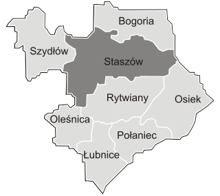
Gmina Staszów is an urban-rural gmina in Staszów County, Świętokrzyskie Voivodeship, in south-central Poland. Its seat is the town of Staszów, which lies approximately 53 kilometres (33 mi) south-east of the regional capital Kielce.
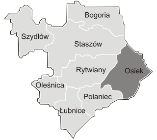
Gmina Osiek is an urban-rural gmina in Staszów County, Świętokrzyskie Voivodeship, in south-central Poland. Its seat is the town of Osiek, which lies approximately 21 kilometres (13 mi) east of Staszów and 71 km (44 mi) south-east of the regional capital Kielce.
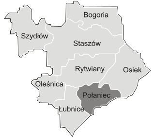
Gmina Połaniec is an urban-rural gmina in Staszów County, Świętokrzyskie Voivodeship, in south-central Poland. Its seat is the town of Połaniec, which lies approximately 17 kilometres (11 mi) south-east of Staszów and 69 km (43 mi) south-east of the regional capital Kielce.

The Afghanistan Research and Evaluation Unit (AREU) is an independent research organization based in Kabul, Afghanistan. It aims to provide a firm basis for policy and practice in the country's rapidly changing environment by conducting in-depth, on-the-ground research. Funding is provided by a variety of governments and agencies.
Ponik is a village in the administrative district of Gmina Staszów, within Staszów County, Świętokrzyskie Voivodeship, in south-central Poland. It lies approximately 6 kilometres (4 mi) west of Staszów and 49 km (30 mi) south-east of the regional capital Kielce.
Smerdyna is a village in the administrative district of Gmina Staszów, within Staszów County, Świętokrzyskie Voivodeship, in south-central Poland. It lies approximately 12 kilometres (7 mi) east of Staszów and 60 km (37 mi) south-east of the regional capital Kielce.
Zagrody is a village in the administrative district of Gmina Staszów, within Staszów County, Świętokrzyskie Voivodeship, in south-central Poland. It lies approximately 5 kilometres (3 mi) north-west of Staszów and 48 km (30 mi) south-east of the regional capital Kielce.
Wierzbka is a village in the administrative district of Gmina Bogoria, within Staszów County, Świętokrzyskie Voivodeship, in south-central Poland. It lies approximately 6 kilometres (4 mi) north-west of Bogoria, 15 km (9 mi) north of Staszów, and 47 km (29 mi) south-east of the regional capital Kielce.
Wola Malkowska is a village in the administrative district of Gmina Bogoria, within Staszów County, Świętokrzyskie Voivodeship, in south-central Poland. It lies approximately 5 kilometres (3 mi) west of Bogoria, 12 km (7 mi) north of Staszów, and 48 km (30 mi) south-east of the regional capital Kielce.
Szczebrzusz is a village in the administrative district of Gmina Łubnice, within Staszów County, Świętokrzyskie Voivodeship, in south-central Poland. It lies approximately 4 kilometres (2 mi) south of Łubnice, 20 km (12 mi) south of Staszów, and 68 km (42 mi) south-east of the regional capital Kielce.
Zrębin is a village in the administrative district of Gmina Połaniec, within Staszów County, Świętokrzyskie Voivodeship, in south-central Poland. It lies approximately 4 kilometres (2 mi) west of Połaniec, 15 km (9 mi) south of Staszów, and 66 km (41 mi) south-east of the regional capital Kielce.
Święcica is a village in the administrative district of Gmina Rytwiany, within Staszów County, Świętokrzyskie Voivodeship, in south-central Poland. It lies approximately 6 kilometres (4 mi) south-west of Rytwiany, 7 km (4 mi) south of Staszów, and 57 km (35 mi) south-east of the regional capital Kielce.
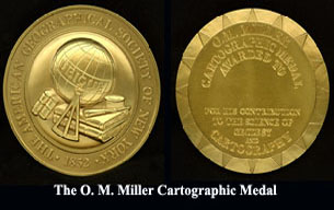
The Osborn Maitland Miller Cartographic Medal was established in 1968 by the American Geographical Society Council. The Osborn Maitland Miller Cartographic Medal honors "outstanding contributions in the field of cartography or geodesy".

The State Land and Cartography Committee of Azerbaijan Republic is a governmental agency within the Cabinet of Azerbaijan in charge of implementing land cadastre, monitoring and reforms; restoration and increasing of land productivity, setting territorial units in Azerbaijan Republic. The ministry is headed by Garib Mammadov.

Department of Geodesy Gdańsk University of Technology – continues the tradition of the Department of Surveying and Cartography, established at Gdańsk University of Technology in 1945.
References
- ↑ "Afghan Geodesy and Cartography Head Office (AGCHO)," Archived November 24, 2011, at the Wayback Machine AREU A-Z Guide, 2010 Edition. Via Transnational Crisis Project. (accessed 23 December 2012)
- 1 2 "Afghan Geodesy and Cartography Head Office (AGCHO)". 2010 AREU A-Z Guide. Transnational Crisis Project. Retrieved 30 May 2014.
- ↑ "Message of the Director". Afghan Geodesy and Cartography Head Office. Archived from the original on 1 May 2013. Retrieved 30 May 2014.
| | This article about government in Afghanistan is a stub. You can help Wikipedia by expanding it. |