Related Research Articles

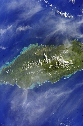
Upolu is an island in Samoa, formed by a massive basaltic shield volcano which rises from the seafloor of the western Pacific Ocean. The island is 75 kilometres long and 1,125 square kilometres in area, making it the second largest of the Samoan Islands by area. With approximately 145,000 inhabitants, it is by far the most populous of the Samoan Islands. Upolu is situated to the southeast of Savai'i, the "big island". Apia, the capital, is in the middle of the north coast, and Faleolo International Airport is at the western end of the island. The island has not had any historically recorded eruptions, although there is evidence of three lava flows, dating back only to between a few hundred and a few thousand years ago.
Tuamāsaga is a district of Samoa, with a population of 95,907. The geographic area of Tuamasaga covers the central part of Upolu island.
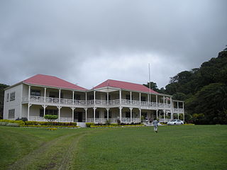
Vailima is the name of a village about four miles south of Apia, the capital of Samoa. The population is 769. Vailima is part of the electoral political district Tuamasaga.
Tafua is a seaside village on the island of Savai'i in Samoa. It is situated on a peninsula on the southeast coast of the island in Palauli district. The population is 406.

Mulinu'u is a small village situated on a tiny peninsula on Upolu island in Samoa. It became the site of the colonial administration in Samoa in the 1870s and continues to be the site for the Parliament of Samoa. It is located on the central north coast of the island and is part of the urban area comprising Apia, the country's capital.
Moata'a is a village on the island of Upolu in Samoa. It is situated on the central north coast of the island, to the east of the capital Apia. The village is in the political district of Tuamasaga.
Sala'ilua is a village on the island of Savai'i in Samoa. It is situated on the south coast of the island in the district of Palauli and the electoral district of Palauli 1. The population is 901.
Alafua is an urban village in the Faleata District in the Samoan capital of Apia.
Taufusi is a village on the Samoan island of Upolu. It is part of the Vaimauga West Electoral Constituency, Tuamasaga District, in the Apia Urban Area of Samoa. The village had a population of 364 at the 2016 census. The village name in English means Swamp as it was a swampy area in late 19th century. Taufusi is bordered by Saleufi to the North, Tuloto to the East, Lalovaea to the South East, Mt. Vaea and Palisi to the South, Vaimea and Fugalei to the West.
Pesega is a village on the island of Upolu in Samoa. It is located on western outskirts of Apia, the country's capita. Pesega is part of Faleata West Electoral Constituency which forms part of the larger political district of Tuamasaga.
Sabine Glacier is a 13.5 km long glacier on the north side of Detroit Plateau, flowing from Mount Bris and Tsarevets Buttress northwards along the east slopes of Korten Ridge, and terminating at the sea in Jordanoff Bay on Davis Coast in Graham Land, Antarctica. Captain Henry Foster gave the name "Cape Sabine" in 1829 to a feature lying southeast of Cape Kater but it has not been possible to identify that cape. This toponym preserves the early use of Sabine in this area. Sir Edward Sabine (1788-1883), English astronomer and geodesist, was a member of the committee which planned the 1829 voyage of Foster in the Chanticleer.
Siutu is a village on the island of Savai'i in Samoa. It is situated on the south coast of the island in the district of Palauli and the electoral district of Palauli 1. The population is 449.
Pata is a village on the island of Upolu in Samoa. It is in the political district of A'ana.
Fa'ato'ialemanu is a village on the island of Upolu in Samoa. It is situated on the north central side of the island and is part of the greater Apia area. The village has a population of 841.
Vaimoso is a village on the island of Upolu in Samoa. It is situated on the north central side of the island near the country's capital Apia. The village is in the political district of Tuamasaga.
Lotopa is a village on the island of Upolu in Samoa. It is situated on the north central side of the island near the country's capital Apia. The village is in the political district of Tuamasaga.
Lepea is a village on the island of Upolu in Samoa. The picturesque settlement of round Samoan houses built in a concentric pattern in large open grounds (malae) is situated 5mins drive west of the capital Apia on the north central coast of the island. It is part of the Tuamasaga electoral district.
Crosse Passage is a small passage leading southeast from Adelaide Anchorage between the Henkes Islands and the Skeen Rocks, off the south end of Adelaide Island. It was named by the UK Antarctic Place-Names Committee in 1963 for Lieutenant Commander Anthony G. Crosse, Royal Navy, First Lieutenant of HMS Protector which was used by the Hydrographic Survey Unit in charting this area in 1961–63.
Hulbe Glacier is a glacier about 10 nautical miles (20 km) long draining the north side of Siple Island, Antarctica. It was named by the Advisory Committee on Antarctic Names after Christina Hulbe, faculty member of the University of Otago, New Zealand, and a theoretical and field researcher of ice motion in Antarctica.
References
- ↑ "Census 2016 Preliminary count" (PDF). Samoa Bureau ofStatistics. p. 6. Retrieved 28 January 2021.
Coordinates: 13°55′S171°47′W / 13.917°S 171.783°W
| | This article about a geographical location in Samoa is a stub. You can help Wikipedia by expanding it. |