Agate Pass

Last updated
The deck of the Agate Pass Bridge, carrying State Route 305 over the pass Agate pass2.jpg
The deck of the Agate Pass Bridge, carrying State Route 305 over the pass
The Agate Pass Bridge from a nearby beach Agate pass1.jpg
The Agate Pass Bridge from a nearby beach

Agate Pass or Agate Passage is a high-current tidal strait in Puget Sound connecting Port Madison and mainland Kitsap County in the US state of Washington. It lies between Bainbridge Island and the mainland of the Kitsap Peninsula near Suquamish. It leads south towards Bremerton, extending about one mile (1.6 km) in a straight, southwesterly direction. The depth is about 20 feet (6.1 m). The shores are wooded and fairly steep. The shoreline is mostly rocky and fringed with kelp to Point Bolin. The tidal currents have velocities up to six knots; the flood tide sets southwesterly, and the ebb tide northeasterly.

The traditional winter village of the Suquamish people was located on Agate Pass. It was the site of Old Man House, the largest longhouse on Puget Sound, and is the location of Haleets, a petroglyph. Agate Pass was unknown to non-native people until it was discovered by the Wilkes Expedition in 1841. Before then, Europeans thought Bainbridge Island was a peninsula. It was named by U.S. Navy Lt. Charles Wilkes in honor of one of the members of the expedition, Alfred Thomas Agate.

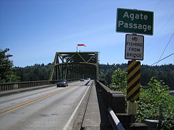
In 1950, a fixed highway bridge, the Agate Pass Bridge was built, connecting Bainbridge Island to the Kitsap Peninsula for the first time. The bridge is listed on the National Register of Historic Places.

47°42′57″N122°33′40″W / 47.7159294°N 122.5609725°W / 47.7159294; -122.5609725


/* External links */

Related Research Articles

<span class="mw-page-title-main">Bainbridge Island, Washington</span> City in Washington, United States

Bainbridge Island is a city and island in Kitsap County, Washington, United States. It is located in Puget Sound. The population was 24,825 at the 2020 census, making Bainbridge Island the second largest city in Kitsap County.

<span class="mw-page-title-main">Indianola, Washington</span> CDP in Washington, United States

Indianola is a census-designated place (CDP) in Kitsap County, Washington, United States, located on the north shore of Port Madison on the Port Madison Indian Reservation, home of the Suquamish Indian Tribe. The population was 3,500 at the 2010 census. It was originally established as a summer community and was a stop for Mosquito Fleet ferries until the 1950s.

<span class="mw-page-title-main">Poulsbo, Washington</span> City in Washington, United States

Poulsbo is a city on Liberty Bay in Kitsap County, Washington, United States. It is the smallest of the four cities in Kitsap County. The population was 11,970 at the 2020 census and an estimated 10,927 in 2018.

<span class="mw-page-title-main">Suquamish, Washington</span> Census-designated place in Washington, United States

Suquamish is a census-designated place (CDP) in Kitsap County, Washington, United States. The population was 4,140 at the 2010 census. Comprising the Port Madison Indian Reservation, it is the burial site of Chief Seattle and the site of the Suquamish tribe winter longhouse known as Old Man House.

<span class="mw-page-title-main">Admiralty Inlet</span>

Admiralty Inlet is a strait in the U.S. state of Washington connecting the eastern end of the Strait of Juan de Fuca to Puget Sound. It lies between Whidbey Island and the northeastern part of the Olympic Peninsula.

<span class="mw-page-title-main">Tacoma Narrows</span> Waterway between the Kitsap Peninsula and Tacoma in Puget Sound, Washington, US

The Tacoma Narrows, a strait, is part of Puget Sound in the U.S. state of Washington. A navigable maritime waterway between glacial landforms, the Narrows separates the Kitsap Peninsula from the city of Tacoma.

<span class="mw-page-title-main">Kitsap Peninsula</span> Peninsula in Puget Sound, Washington, United States

The Kitsap Peninsula lies west of Seattle across Puget Sound, in Washington state in the Pacific Northwest. Hood Canal separates the peninsula from the Olympic Peninsula on its west side. The peninsula, a.k.a. "Kitsap", encompasses all of Kitsap County except Bainbridge and Blake Islands, as well as the northeastern part of Mason County and the northwestern part of Pierce County. The highest point on the Kitsap Peninsula is Gold Mountain. The U.S. Navy's Puget Sound Naval Shipyard, and Naval Base Kitsap are on the peninsula. Its main city is Bremerton.

<span class="mw-page-title-main">Port Orchard</span>

<span class="mw-page-title-main">Blake Island</span> Island in the Puget Sound, Washington, U.S.

Blake Island is a Puget Sound island in Kitsap County, Washington, United States, that is preserved as Blake Island Marine State Park. The island lies north of Vashon Island, south of Bainbridge Island, and east of Manchester. On the northeast end of the island is Tillicum Village, a tourist attraction based on Northwest Coast Indian arts, culture, and food. The park is managed by the Washington State Parks and Recreation Commission.

<span class="mw-page-title-main">Colvos Passage</span> Tidal strait in Washington State

<span class="mw-page-title-main">Sinclair Inlet</span> Embayment in Puget Sound, Washington, U.S.

Sinclair Inlet is a shallow embayment in the western part of Puget Sound in Kitsap County, Washington, USA. It has a maximum depth of 20 meters. It is the southwestern extension of Port Orchard, and it touches the shores of three of Kitsap County's four incorporated cities: Bremerton, Bainbridge Island, and Port Orchard. It is connected to Dyes Inlet by the Port Washington Narrows and to Puget Sound by Rich Passage. It was named by United States Navy explorer Charles Wilkes for George T. Sinclair, acting master of one of his ship's crews. The Puget Sound Naval Shipyard is located on the north shore of Sinclair Inlet.

<span class="mw-page-title-main">Agate Pass Bridge</span> Bridge in Suquamish, Washington

The Agate Pass Bridge is a structural steel truss cantilever bridge spanning Agate Pass, connecting Bainbridge Island to the Kitsap Peninsula. It was built in 1950, and it replaced a car ferry service which dated from the 1920s. The bridge provides a direct route along Washington State Route 305 between Seattle, via the Seattle-Bainbridge Island ferry, and the Kitsap Peninsula.

<span class="mw-page-title-main">Pickering Passage</span> Strait in Puget Sound, Washington

<span class="mw-page-title-main">Rich Passage</span>

The Manette Peninsula is a headland that is part of the larger Kitsap Peninsula, located on the eastern flank of the Kitsap Peninsula, in western Washington, United States.

Case Inlet, in southern Puget Sound in the U.S. state of Washington, is an arm of water between Key Peninsula to the east and Harstine Island to the west. Its northern end, called North Bay, reaches nearly to Hood Canal, creating the defining isthmus of Kitsap Peninsula. Case Inlet is the boundary between Pierce County and Mason County. The southern end of Case Inlet connects to Nisqually Reach, part of the southern basin of Puget Sound. Herron Island lies in Case Inlet.

<span class="mw-page-title-main">Washington State Route 305</span> Highway in Washington

State Route 305 (SR 305) is a 13.50-mile-long (21.73 km) state highway in the U.S. state of Washington, primarily serving Bainbridge Island in Kitsap County and connecting it to Seattle in King County via the Seattle–Bainbridge Island ferry. The highway travels north through Bainbridge Island and leaves the island on the Agate Pass Bridge into the Kitsap Peninsula. SR 305 continues northwest through Poulsbo, intersecting SR 307 and ending at the SR 3 freeway. The highway was created during the 1964 highway renumbering and was preceded by Secondary State Highway 21A (SSH 21A), established in 1937. The ferry, part of the highway since 1994, is served by the Jumbo Mark-II-classMV Tacoma and MV Wenatchee and operates on a 35-minute crossing time.

Hale Passage is the name of two different bodies of water in Puget Sound, in the U.S. state of Washington.

Pritchard Park is a 50-acre (20 ha) former Superfund environmental cleanup site on the shore of Bainbridge Island's Eagle Harbor in Washington state.