Agate Pass Bridge | |
|---|---|
 | |
| Coordinates | 47°42′45″N122°33′58″W / 47.7124°N 122.566°W |
| Carries | |
| Crosses | Agate Pass |
| Locale | Suquamish, Washington |
| Owner | WSDOT |
| Heritage status | NRHP |
| Characteristics | |
| Design | Steel cantilever truss |
| Material | Steel |
| Total length | 1,229 feet (375 m) |
| Longest span | 300 feet (91 m) |
| Clearance below | 75 feet (23 m) |
| History | |
| Construction end | 1950 |
| Construction cost | $1,351,363 |
| Statistics | |
| Toll | until October 1, 1951 |
Agate Pass Bridge | |
 | |
| Location | WA 305 over Agate Passage |
| Nearest city | Suquamish, Washington |
| Built | 1950 |
| Architect | State Dept of Hwys |
| MPS | Bridges of Washington State MPS |
| NRHP reference No. | 95000625 |
| Added to NRHP | May 24, 1995 |
| Location | |
 | |
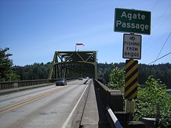
The Agate Pass Bridge is a structural steel truss cantilever bridge spanning Agate Pass, connecting Bainbridge Island to the Kitsap Peninsula. It was built in 1950, and it replaced a car ferry service which dated from the 1920s. [1] The bridge provides a direct route along Washington State Route 305 between Seattle, via the Seattle-Bainbridge Island ferry, and the Kitsap Peninsula.
The Agate Pass Bridge is 1,229 feet (375 m) long and is 75 feet (23 m) above the water and has a channel clearance of 300 feet (91 m) between piers. [2]
The original construction cost of $1,351,363 was paid out of the motor vehicle fund, and operated as a toll bridge from October 7, 1950, until October 1, 1951, when costs were repaid by a bond issue passed by the Washington State Legislature. The Washington Toll Bridge Authority managed the bridge during the year it took to repay the bond. [3]
The Agate Pass Bridge is listed on the National Register of Historic Places.