
The Reclamation Act of 1902 is a United States federal law that funded irrigation projects for the arid lands of 17 states in the American West.

The Malheur River is a 190-mile-long (306 km) tributary of the Snake River in eastern Oregon in the United States. It drains a high desert area, between the Harney Basin, the Blue Mountains and the Snake.

New Melones Dam is an earth and rock filled embankment dam on the Stanislaus River, about 5 miles (8.0 km) west of Jamestown, California, United States, on the border of Calaveras County and Tuolumne County. The water impounded by the 625-foot-tall (191 m) dam forms New Melones Lake, California's fourth-largest reservoir, in the foothills of the Sierra Nevada east of the San Joaquin Valley. The dam serves mainly for irrigation water supply, and also provides hydropower generation, flood control, and recreation benefits.

San Luis Dam, also known as B.F. Sisk Dam, is a major earth-filled dam in Merced County, California, which forms San Luis Reservoir, the largest off-stream reservoir in the United States. The dam and reservoir are located in the Diablo Range to the east of Pacheco Pass and about 10 miles (16 km) west of Los Banos. San Luis Dam, a jointly-owned state and federal facility, stores more than 2 million acre feet (2.5 km3) of water for the California State Water Project and the federal Central Valley Project. Although the dam is located in the valley of San Luis Creek, the majority of its water comes from man-made aqueducts which are supplied from other rivers in Northern California.

Trinity Dam is an earthfill dam on the Trinity River located about 7 miles (11 km) northeast of Weaverville, California in the United States. The dam was completed in the early 1960s as part of the federal Central Valley Project to provide irrigation water to the arid San Joaquin Valley.

Millerton Lake is an artificial lake near the town of Friant, about 15 mi (24 km) north of downtown Fresno, California, United States. The reservoir was created by the construction of 319 ft high Friant Dam on the San Joaquin River which, with the lake, serves as much of the county line between Fresno County to the south and Madera County to the north.

Thief Valley Reservoir is a large reservoir on the Powder River in Eastern Oregon, United States. Primarily used for irrigation purposes, it lies at an elevation of approximately 3,000 feet, covers an area of 740 acres, and impounds 17,600 acre-feet. It provides good angling opportunities for rainbow trout in years of high water.

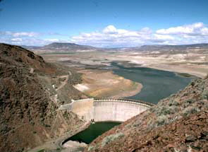
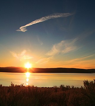
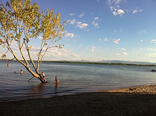
Owyhee Reservoir or Owyhee Lake is a reservoir on the Owyhee River in Malheur County, Oregon, United States. Located in far Eastern Oregon near the Idaho border, the reservoir is Oregon's longest at 52 miles (84 km). The 13,900-acre (56 km2) lake is home to several species of fish, including crappie, rainbow trout, largemouth bass, smallmouth bass, yellow perch, and brown bullhead. An artificial lake, it was created in 1932 with the completion of the Owyhee Dam. The lake supplies water for irrigation for 1,800 farms covering 118,000 acres of land in Eastern Oregon and Southwestern Idaho. Seasonal Lake Owyhee State Park is located on the northeast shore and includes a boat ramp.
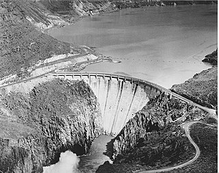
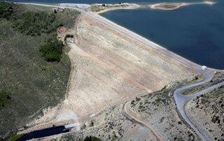
Owyhee Dam is a concrete arch-gravity dam on the Owyhee River in Eastern Oregon near Adrian, Oregon, United States. Completed in 1932 during the Great Depression, the dam generates electricity and provides irrigation water for several irrigation districts in Oregon and neighboring Idaho. At the time of completion, it was the tallest dam of its type in the world. The dam is part of the Owyhee Dam Historic District, which is listed on the National Register of Historic Places.
Warm Springs Reservoir is a reservoir on the boundary between Harney and Malheur counties in the U.S. state of Oregon. It is located 13 miles (21 km) southwest of Juntura at an elevation of 3,406 feet (1,038 m). The lake's primary inflow and outflow are both the Malheur River.

Bully Creek Reservoir is a reservoir in Malheur County of the U.S. state of Oregon. It is an impoundment of Bully Creek, a tributary of the Malheur River.

The Rio Grande Project is a United States Bureau of Reclamation irrigation, hydroelectricity, flood control, and interbasin water transfer project serving the upper Rio Grande basin in the southwestern United States. The project irrigates 193,000 acres (780 km2) along the river in the states of New Mexico and Texas. Approximately 60 percent of this land is in New Mexico. Some water is also allotted to Mexico to irrigate some 25,000 acres (100 km2) on the south side of the river. The project was authorized in 1905, but its final features were not implemented until the early 1950s.

The Klamath Diversion was a federal water project proposed by the U.S. Bureau of Reclamation in the 1950s. It would have diverted the Klamath River in Northern California to the more arid central and southern parts of that state. It would relieve irrigation water demand and groundwater overdraft in the Central Valley and boost the water supply for Southern California. Through the latter it would allow for other Southwestern states—Arizona, Nevada, New Mexico and Utah—as well as Mexico to receive an increased share of the waters of the Colorado River.
The North Fork Malheur River is a 59-mile (95 km) tributary of the Malheur River in eastern Oregon in the United States. Rising in Big Cow Burn in the Blue Mountains, it flows generally south to join the larger river at Juntura. The upper 25.5 miles (41.0 km) of the river have been designated Wild and Scenic. This part of the river basin offers camping, hiking, and fishing opportunities in a remote forest setting. The lower river passes through Beulah Reservoir, which stores water for irrigation and has facilities for boaters.
Mason Dam is a dam near Baker City, Oregon, in Baker County, of the north-eastern part of the state.
Antelope Reservoir is a large body of water impounded for irrigation in a semi-arid region of southeastern Oregon in the United States. Located near the small city of Jordan Valley in Malheur County, it is about 10 miles (16 km) west of Oregon's border with Idaho. Although the lake is formed by a dam across Jack Creek, most of the water enters the reservoir via the Antelope Feeder Canal. It diverts water to the reservoir from nearby Jordan Creek at a point near the Idaho border. Jack Creek, which carries minor outflows from the reservoir, empties into Jordan Creek further downstream.
Soldier Creek Dam is an earthen dam on the Strawberry River, located within the Uinta National Forest in southern Wasatch County, Utah, United States.
Deer Flat Upper Embankment is a dam in the western United States in southwestern Idaho. Located in the Treasure Valley in Canyon County, it is directly southwest of Nampa.
