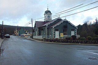
Llangammarch Wells or simply Llangammarch is a village in the community of Llangamarch in Powys, Wales, lying on the Afon Irfon, and in the historic county of Brecknockshire (Breconshire).
Easton is a village and civil parish in the South Kesteven district of Lincolnshire, England. It is situated almost 2 miles (3.2 km) north from Colsterworth, and 1 mile (1.6 km) east from the A1 road. It is in the civil parish of Stoke Rochford.
St Harmon is a village in Radnorshire, Powys, Wales. The population of the community at the 2011 census was 593. It is located on the Afon Marteg on the B4518 road running between Llanidloes and Rhayader. The parish church is called Saint Garmon, with many people assuming it has been spelt incorrectly.

Aymestrey is a village and civil parish in north-western Herefordshire, England. The population of this civil parish at the 2011 Census was 351.

North Andros is one of the 31 districts of the Bahamas. It is also the largest district in the country. It has some of the largest settlements on Andros Island and many churches as well. The population is 3,898.

The Severn Way is a waymarked long-distance footpath in the United Kingdom, which follows the course of the River Severn through Mid Wales and western England.
Llanfihangel-ar-Arth is a village and a community in the county of Carmarthenshire, Wales.

Llanilar is a village and community in Ceredigion, Wales, about 4 kilometers (2.5 mi) southeast of Aberystwyth. It is the eponym of the hundred of Ilar. The population at the 2011 census was 1,085.

Moccas is a village and civil parish in the English county of Herefordshire. It is located 14 miles (23 km) west of Hereford. The population of the civil parish taken at the 2011 census was 105.
The A606 is an A road in England that starts in West Bridgford (52.9274°N 1.1299°W) and heads southeastwards through Leicestershire and the towns of Melton Mowbray and Oakham, terminating at Stamford, Lincolnshire (52.6528°N 0.4836°W), on the former Great North Road.

Kilmihil is a village in the Barony of Clonderlaw, west County Clare, Ireland. It is also a civil parish and an ecclesiastical parish in the Roman Catholic Diocese of Killaloe. The area was officially classified as part of the West Clare Gaeltacht; an Irish-speaking community; until 1956.

Rathmichael is a suburb in the south-east of Dublin in the county of Dún Laoghaire–Rathdown. It is situated west of Shankill from which it is separated by the M50/M11 motorways. It is also a civil parish in the barony of Rathdown.
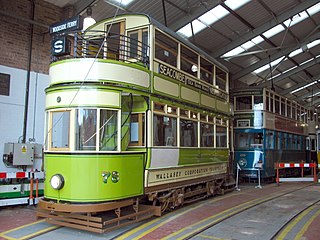
Wirral Transport Museum is a museum situated approximately 0.5 miles (800 m) from the Mersey Ferry service at Woodside, Birkenhead, England.

The Elan aqueduct crosses Wales and the Midlands of England, running eastwards from the Elan Valley Reservoirs in Mid Wales to Birmingham's Frankley Reservoir, carrying drinking water for Birmingham.

Cwmyoy is an extensive rural parish in Monmouthshire, Wales for the valley and parish, for the village. The standard Welsh name is Cwm Iau / Cwm-iau. In the Gwentian dialect of Welsh that was spoken here until the late 1800s, the name was pronounced as Cwm Iou. The 'English' name is in fact this local dialect form in a more English spelling. The name of the valley probably originates from the Welsh word 'iau' meaning yoke, in reference to the shape of the hill surrounding it.

Llandysilio is a village and community in Montgomeryshire, Powys, Wales.

Ratley is a village in the civil parish of Ratley and Upton, Stratford-on-Avon District, Warwickshire, England. The population of the civil parish in 2011 was 327. It is on the northwest side of the Edge Hill escarpment about 200 metres (660 ft) above sea level. The village is close to the county border with north Oxfordshire, some 7 miles northwest of Banbury, the closest town.
Grand Chenier is an unincorporated community in Cameron Parish, Louisiana, United States. Its population is estimated at 352. Its ZIP code is 70643.

St. Mary's Church, Mansfieldstown is a medieval church and National Monument in County Louth, Ireland.

Kiltoom, also Kiltomb, in Irish Cill Tuama, is a civil parish as well as an electoral division in County Roscommon, Republic of Ireland. There is also the eponymous townland in the parish. Kiltoom is located northwest of Athlone on the western shore of Lough Ree.