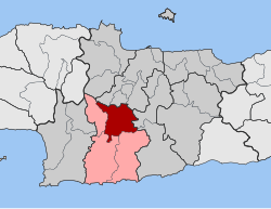
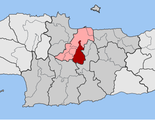
Tragano is a town and a former municipality in Elis, West Greece, Greece. Since the 2011 local government reform it is part of the municipality Pineios, of which it is a municipal unit. The municipal unit has an area of 41.475 km2. Tragano is situated in a flat, rural area, north of the river Pineios. It is 2 km east of Stafidokampos, 4 km east of Andravida, 3 km north of Agia Mavra, 5 km northwest of Avgeio and 8 km northeast of Gastouni. It is 2 km southeast of the Andravida Air Base.

Akrata, is a town and a former municipality in Achaea, West Greece, Greece. Since the 2011 local government reform it is part of the municipality Aigialeia, of which it is a municipal unit. The municipal unit has an area of 180.169 km2. Akrata is located on the right bank of the river Krathis, 3 km from its outflow into the Gulf of Corinth. The Greek National Road 8A/E65 and the railway from Patras to Corinth pass through the municipal unit, northeast of the town. The nearest town is Aigeira, 4 km to the east. It is 23 km southeast of Aigio, 52 km east of Patras and 23 km northeast of Kalavryta.
Markopoulo Oropou is a town and a former community of East Attica, Greece. Since the 2011 local government reform it is part of the municipality Oropos, of which it is a municipal unit. The municipal unit has an area of 23.177 km2.

Vilia is a village and a former municipality of West Attica, Greece. Since the 2011 local government reform it is part of the municipality Mandra-Eidyllia, of which it is a municipal unit. Its population was 2,514 at the 2021 census. It is part of Athens metropolitan area. The inhabitants of Vilia are Arvanites.

Platanias is a village and municipality on the Greek island of Crete. It is located about 10 km (6.2 mi) west from the city of Chania and east of Kissamos, on Chania Bay. The seat of the municipality is the village Gerani. Platanias is a popular tourism village with beaches, several hotels, restaurants, bars, nightclubs and souvenir shops. The area is especially popular with Scandinavian tourists with the season running from April to October. Not far from the coast is the island of Agioi Theodoroi.

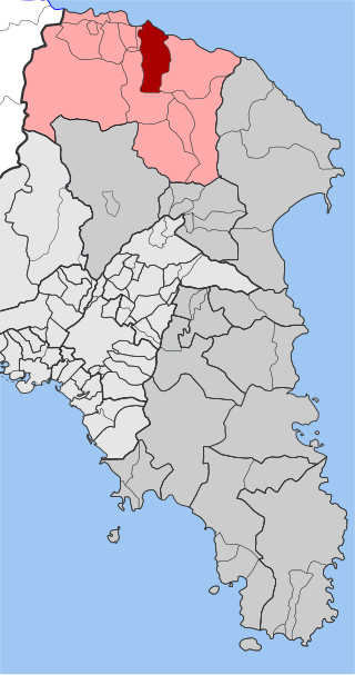
Evdilos is a village and a former municipality in the central part of the island of Ikaria, North Aegean, Greece. Since the 2011 local government reform it is part of the municipality Ikaria, of which it is a municipal unit. 40 km northwest of Agios Kirykos. Its name means visible and freely rendered open horizon.

Gazi is a Western suburb of Heraklion and a former municipality in the Heraklion regional unit of Crete in Greece. Since the 2011 local government reform, it has been part of the municipality Malevizi, of which it is a municipal unit. It lies 6 kilometres west of Heraklion, on the north coast of Crete. With 16,256 inhabitants, it was the seat of the municipality of Gazi, which comprised several nearby villages with a total population of 20,918 and an area of 95.81 square kilometres (36.99 sq mi).

Skiritida is a former municipality in Arcadia, Peloponnese, Greece. It was formed at the 1997 Kapodistrias reform; the seat of the municipality was in Vlachokerasia. Since the 2011 local government reform it is part of the municipality Tripoli, of which it is a municipal unit. The municipal unit has an area of 186.164 km2. It had a population of 930 at the 2021 census.

Tritaia is a former municipality in Achaea, West Greece, Greece. Since the 2011 local government reform it is part of the municipality Erymanthos, of which it is a municipal unit. The municipal unit has an area of 244.798 km2. The seat of the municipality was in Stavrodromi. Tritaia was named after the ancient Achaean city Tritaea, which was located near the present village Agia Marina. Tritaia is situated in mountainous southern Achaea, on the border with Elis. It nearly surrounds the municipal unit Kalentzi. Mount Erymanthos is located in the eastern part of Tritaia. The Greek National Road 33 runs through Tritaia.

Gorgolainis is a former municipality in the Heraklion regional unit, Crete, Greece. Since the 2011 local government reform it is part of the municipality Heraklion, of which it is a municipal unit. The municipal unit has an area of 41.458 km2. Population 2,525 (2021). The seat of the municipality was in Agios Myronas. Another village within the municipal unit is Kato Asites.

Episkopi is a former municipality in the Heraklion regional unit, Crete, Greece. Since the 2011 local government reform, it has been part of the municipality Hersonissos, of which it is a municipal unit. The municipal unit has an area of 45.500 km2 (17.568 sq mi). The population of Episkopi as of 2021 is 2,291.
Temenos is a former municipality in the Heraklion Regional Unit, Crete, Greece. Since the 2011 local government reform it is part of the municipality Heraklion, of which it is a municipal unit. The municipal unit has an area of 56.608 km2. Population 3,421 (2021). The seat of the municipality was in Profitis Ilias.

Tympaki is a town and a former municipality in the Heraklion regional unit, Crete, Greece. Since the 2011 local government reforms it is part of the municipality of Faistos, of which it is a municipal unit, the unit has an area of 157.122 km2 (60.665 sq mi).
Agios Dimitrios is a former municipality in the Ioannina regional unit, Epirus, Greece. Since the 2011 local government reform it is part of the municipality Dodoni, of which it is a municipal unit. Population 3,277 (2021), its area is 231.473 km². The seat of the municipality was in Theriakisi. The largest village is Kato Mousiotitsa which has a school, gymnasium and lyceum. The municipal unit covers the northwestern part of the Xerovouni mountains.

Sellana is a former municipality in the Karditsa regional unit, Thessaly, Greece, named after the ancient city of "Sellana" or "Silàna". Since the 2011 local government reform it is part of the municipality Palamas, of which it is a municipal unit. The municipal unit has an area of 89.490 km2. The seat of the municipality was in Proastio, which has 1,434 inhabitants (2021). Other communities in the municipal unit are those of Marathea, Agia Triada (548), Pedino (505) and Kalogriana (475).

Agia is a village and a municipality in the Larissa regional unit, Thessaly, Greece. Agia is located east of Larissa and south of Melivoia. The Mavrovouni mountains dominate the south and the Aegean Sea lies to the east.

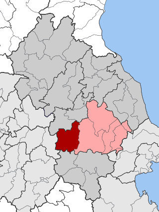
Evrymenes is a former municipality in the Larissa regional unit, Thessaly, Greece. Since the 2011 local government reform it is part of the municipality Agia, of which it is a municipal unit. The municipal unit has an area of 95.284 km 2. The seat of the municipality was in Stomio. It was named after the ancient city Eurymenae.
Krannonas is a village and a former municipality in the Larissa regional unit, Thessaly, Greece. Since the 2011 local government reform it is part of the municipality Kileler, of which it is a municipal unit. It is located southwest of the regional capital Larissa. In 2021 its population was 127 for the community and 2,007 for the municipal unit. The municipal unit has an area of 205.242 km2. The seat of the municipality was Agioi Anargyroi. It is located north of Farsala and NNE of Palamas and Karditsa.
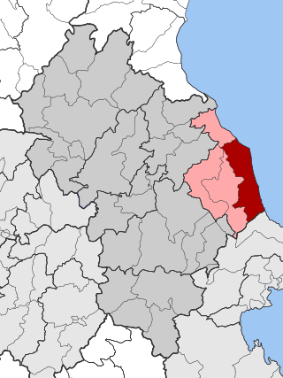
Melivoia is a town and a former municipality in the Larissa regional unit, Thessaly, Greece. Since the 2011 local government reform it is part of the municipality Agia, of which it is a municipal unit. The municipal unit has an area of 197.633 km2. The seat of the municipality was in Kato Sotiritsa. Melivoia is located east of Larissa, the capital of the regional unit and Thessaly, and a few kilometers north of Agia. The municipal unit stretches along the Aegean Sea coast, at the foot of Mount Ossa. It was named after the ancient city Meliboea. The municipal unit borders on Magnesia to the southeast.

East Selino is a former municipality in the Chania regional unit, Crete, Greece. Since the 2011 local government reform it is part of the municipality Kantanos-Selino, of which it is a municipal unit. The municipal unit has an area of 136.555 km2 (52.724 sq mi). It is situated on the south-west coast of the island of Crete. It was part of the former Selino Province which covered the mountain and coastal region west of Sfakia. The seat of the municipality was Kampanos.