Agraciada Beach is a historic beach area in Uruguay.
Agraciada Beach is a historic beach area in Uruguay.
It is situated on the eastern bank of the Uruguay River, within the Soriano Department, on the Uruguayan side of the river, opposite territory in the Argentine province of Entre Ríos.
On April 19, 1825, the Thirty-Three Orientals, who were to be credited with liberating Uruguay from Brazilian occupation, landed at Agraciada Beach.
This landing of the historic Thirty Three at the beach proved to be one of the significant stages in the establishing the independence of Uruguay.
A monument to the arrival of the Thirty-Three Orientals was erected in 1863 by local landowner don Domingo Ordoñana at the edge of the beach in the 19th century.
An avenue near the Palacio Legislativo in Montevideo was formerly named after the Agraciada Beach.
The beach was formerly known as 'graseada', from 'grasería', (Spanish: 'chandlery'), given the prior existence of a chandlery at that location. The word 'graseada' was later corrupted to the form 'agraciada' (Spanish: 'pretty', 'good looking'), and which was to become the durable form in the name.

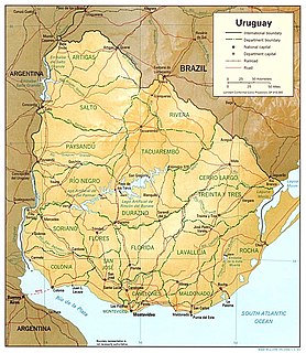
Uruguay is a country in the southeastern region of South America, bordering the Atlantic Ocean, between Argentina and Brazil. It is located in the Southern Hemisphere on the Atlantic seaboard of South America between 53 and 58 west longitude and 30 and 35 south latitude. It is bordered to the west by Argentina, on the north and northeast by Brazil, and on the southeast by the Atlantic Ocean, which makes up Uruguay's coast.

José Gervasio Artigas Arnal was a political leader, military general, statesman and national hero of Uruguay and the broader Río de la Plata region.
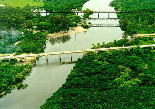
Río Negro Department is a department of the northwestern region of Uruguay. It has an area of 9,282 km2 (3,584 sq mi) and a population of 54,765. Its capital is Fray Bentos. It borders Paysandú Department to the north, Tacuarembó Department to the east, Durazno Department to the southeast, Soriano Department to the south and has the Río Uruguay flowing at its west, separating it from Argentina.
Treinta y Tres is the capital city of the Treinta y Tres Department in eastern Uruguay.
Banda Oriental, or more fully Banda Oriental del Uruguay, was the name of the South American territories east of the Uruguay River and north of Río de la Plata that comprise the modern nation of Uruguay; the modern state of Rio Grande do Sul, Brazil; and some of the modern state of Santa Catarina, Brazil. It was the easternmost territory of the Viceroyalty of the Río de la Plata.
Soriano is a department of Uruguay. Its capital is Mercedes. It is located on the west of the country, south of Río Negro Department, north of Colonia Department and west of Flores Department. Its western border is the Río Uruguay, separating it from Argentina.
Villa Soriano is a town in the Soriano Department of Uruguay. Historically, it was also known as Santo Domingo de Soriano. It had acquired the status of "Villa" (town) before the Independence of Uruguay.
The Treinta y Tres Orientales was a militant revolutionary group led by Juan Antonio Lavalleja and Manuel Oribe against the Empire of Brazil. Their actions culminated in the foundation of modern Uruguay. They became famous by the name of the Treinta y Tres Orientales when, in 1825, they began an insurrection for the independence of Oriental Province, a historical territory encompassing modern Uruguay and part of modern Brazilian Rio Grande do Sul State, from Brazilian control.
19 April is the anniversary of the Landing of the 33 Patriots in Uruguay, also known as the Thirty-Three Orientals, called 'Orientals' because Uruguay was known as the Banda Oriental, or the "Eastern Bank" of the Río de la Plata, the western shore being Argentina.

Cisplatina Province or Cisplatine Province was a Brazilian province in existence from 1821 to 1828 created by the Luso-Brazilian invasion of the Banda Oriental. From 1815 until 1822 Brazil was a constituent kingdom of the United Kingdom of Portugal, Brazil and the Algarves. After the independence of Brazil and the formation of the Empire of Brazil the Cisplatina province remained part of it. In 1828, following the Preliminary Peace Convention, the Cisplatina province became independent as Uruguay.

Brazil–Uruguay relations encompass many complex relations over the span of three centuries, beginning in 1680 with the establishment of the Colónia do Sacramento, to the present day, between the Federative Republic of Brazil and the Oriental Republic of Uruguay. Brazil and Uruguay are neighbouring countries in South America, and share close political, economic and cultural ties. The singularity of the bilateral relationship between the two countries originates from a strong historical connection – marked by important events, such as the establishment of the Colónia do Sacramento in 1680, the invasion of the Banda Oriental by Brazil in 1815 and the subsequent creation of the Província Cisplatina, and Uruguay's independence from Brazil in 1828. The bilateral relationship was further defined by the Uruguayan Civil War (1839–1851) and the Paraguayan War (1864–1870).
Tourism in Uruguay is one of the most important facets of the nation's economy.
Don Domingo Ordoñana (1829-1897), was a prominent rancher in Soriano Department in Uruguay.

Libertador Avenue is a major avenue in Montevideo, Uruguay. It stretches north from the Legislative Palace in Aguada to Plaza Fabini in Centro, and is named after Juan Antonio Lavalleja, revolutionary figure and politician, who led the group of the Thirty-Three Orientals in the insurrection for the independence of Oriental Province.
Ombúes de Lavalle is a small city located in the north of Colonia Department in southwestern Uruguay. It is named after the Argentine General Juan Lavalle. The term «Ombúes» is the Spanish plural for «Ombú», a tree originary of the Pampas region, in southern South America, and a national symbol of both Argentina and Uruguay.
Agraciada is a village located in southwestern Uruguay, on the border of Soriano Department with Colonia Department with parts in both departments.
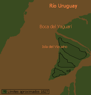
Vizcaíno Island is an island in Uruguay located on the Negro River estuary, at its confluence with Uruguay River. It is bordered by the Negro river to the South, Vizcaíno creek to the east, Uruguay river to the North and Yaguarí creek on the West. Yaguarí creek is a narrow deep channel between Vizcaíno island and Lobos Island, and is the main river mouth of the Negro river.
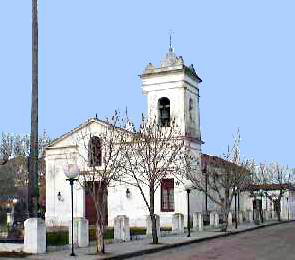
The Chapel of Saint Dominic Soriano is a Roman Catholic church building in Villa Soriano, Soriano Department, Uruguay.
Lobos is a big island in Uruguay, at the confluence of Negro River and Uruguay River. Politically it belongs to Rio Negro department. Up to the 19th century, the island was actually three islets, the largest called Vizcaíno, same as the island across the Yaguarí Creek.
Claudia Josefa Palacios González was an Uruguayan painter and miniaturist of the nineteenth century. She is best known for creating the first visual representation of Uruguayan independence episode known as Desembarco de los Treinta y Tres Orientales.
Capital: Mercedes | ||
| Municipaliites |  | |
| Towns and villages | ||
| Sights | ||