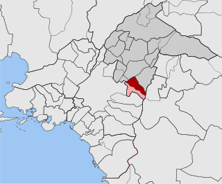
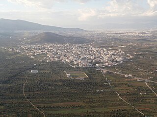
Agrilitsa is a semi-mountainous village of the regional unit of Argolis in the Peloponnese. It is located at a height of 280 meters and[2] is built on the valley of Xerias in the foothils of Mount Artemisio. Several tributaries of the river Xerias run through the village. In the Greek census of 2021 it had a permanent population of 98 people and it is the main settlement of the local community of Karya. The main church of the village is the Church of the Annunciation, but several chapels can also be found in the area.[2]
Agrilitsa was once the winter village of the inhabitants of Karya who moved their flocks from the high pastures of Mount Artemisio to the lowlands of Agrilitsa at the end of every October, only to return there in May. It was first recognized as a separate settlement in 1952[3] and since then it has become the main settlement in the area. The village has an active elementary school[4] and several businesses, mostly related to the local olive oil and dairy/cheese production.
The climate is typical hot-summer Mediterranean with warm, dry summers and cool, wet winters and is similar to that of Argos.
This article needs additional or more specific categories. Please help out by adding categories to it so that it can be listed with similar articles.(May 2024)
Related Research Articles
Xylokastro is a seaside town or village and a former municipality in Corinthia in the Peloponnese, Greece. Since the 2011 local government reform it is part of the municipality Xylokastro-Evrostina, of which it is a unit or component. The municipal unit has an area of 310.252 km2.
Holargos is a town and a suburb in the Athens urban area, Greece, located northeast of the Athens city proper and about 6 kilometers away from Syntagma Square. Since the 2011 local government reform it is part of the municipality Papagou-Cholargos, of which it is the seat and a municipal unit. The municipal unit has an area of 3.950 km2. The main thoroughfare is Mesogeion Avenue, which connects Cholargos with central Athens and the northern beltway Motorway 6.
Argostoli is a town and a municipality on the island of Kefalonia, Ionian Islands, Greece. Since the 2019 local government reform it is one of the three municipalities on the island. It has been the capital and administrative centre of Kefalonia since 1757, following a population shift down from the old capital of Agios Georgios, also known as Kastro, to take advantage of the trading opportunities provided by the sheltered bay upon which Argostoli sits.
Levidi is a small town and a former municipality in Arcadia, Peloponnese, Greece. Since the 2011 local government reform it is part of the municipality Tripoli, of which it is a municipal unit. The municipal unit has an area of 312.641 km2. The town is situated on the northeastern slope of the Mainalo mountains, at about 850 m elevation. Levidi is 9 km northwest of Kapsas, 10 km east of Vytina, 12 km southwest of Kandila and 20 km northwest of Tripoli. It is at the junction of the Greek National Road 74 (Tripoli–Pyrgos) and the Greek National Road 66.
Ierapetra is a Greek city and municipality located on the southeast coast of Crete.
Oleni is a village and a former municipality in Elis, West Greece, Greece.
Spata, is a town 20 kilometres (12 mi) east of downtown Athens, Greece. Since the 2011 local government reform it is part of the municipality Spata-Artemida, of which it is the seat and a municipal unit. The municipal unit has an area of 55.042 km2. It is part of the Athens metropolitan area.
Litochoro is a town and a former municipality in the southern part of the Pieria regional unit, Macedonia, Greece. Since the 2011 local government reform it has been part of the Dio-Olympos municipality, of which it is the seat and a municipal unit. It is located at the base of Mount Olympus, on the western shore of the Thermaic Gulf. The first recorded mention of Litochoro is in an account of a visit by Saint Dionysius to Mount Olympus in the 16th century. The town is a popular destination for those wishing to climb Mount Olympus as almost all climbing routes begin to the southwest of the town. One of the most famous Litohorians was Christos Kakkalos, who made the first modern unaided ascent of Mount Olympus in 1913.
Kalamos is a mountainous island and a former community in the Ionian Islands, Greece. Since the 2011 local government reform it is part of the municipality Lefkada, of which it is a municipal unit. It lies east of Lefkada, near the Greek mainland. It has a wintering population of around 500 people, which is swelled substantially in the summer by tourists.
Kato Nevrokopi is a municipality and town within that municipality in the northwest section of the Drama regional unit, Greece. Before the 2011 local government reform, it was the largest municipality in all of Greece, covering an area of 873.552 km2. The 2021 census reported a population of 5,323 inhabitants. The region is known for the very low temperatures during the winter and for its famous agricultural products such as potatoes and beans. The area has several features to attract tourists: the ski center of Falakro, the traditional settlement in the village of Granitis, the historical bunker of Lise, the artificial lakes of Lefkogeia and Potamoí, the spectacular routes in the forests, the old churches. The forest paths offer excellent views to hikers. The largest towns are Kato Nevrokopi, Volakas (783), Perithorio (569), Lefkogeia (321), Ochyro (314), Kato Vrontou (287) and Vathytopos (255). On the territory of the municipality are located several abandoned villages, including Monastiri and Mavrochori.
Kythnos, commonly called Thermia, is a Greek island and municipality in the Western Cyclades between Kea and Serifos. It is 56 nautical miles (104 km) from the Athenian harbor of Piraeus. The municipality Kythnos is 100.187 km2 (38.68 sq mi) in area and has a coastline of about 100 km (62 mi). Mount Kakovolo is island's highest peak (365m).
Plomari is a town and a former municipality on the island of Lesbos, North Aegean, Greece. Since the 2019 local government reform it is part of the municipality Mytilene, of which it is a municipal unit. It is the only sizable coastal settlement in the south, and the second largest town on Lesbos. The municipal unit of Plomari is the southernmost on Lesbos island and has a land area of 122.452 km2 and a 2021 census population of 4,852. Its largest towns or villages are Plomári, the former municipal seat, Plagiá, Palaiochóri, Megalochóri, and Akrási.
Samarina is a village and a former municipality in Grevena regional unit, West Macedonia, Greece. Since the 2011 local government reform it is part of the municipality Grevena, of which it is a municipal unit. Its population primarily consists of Aromanians. The population was 253 people as of 2021. It attracts many tourists due to its scenic location and beautiful pine and beech forests. The municipal unit has an area of 97.245 km2.
Karya is a village, a community and a municipal unit of the Elassona municipality. Before the 2011 local government reform it was an independent community. The community of Karya covers an area of 74.964 km2 while the municipal unit covers 158.685 km2.
Karya is a former municipality on the island of Lefkada, Ionian Islands, Greece. Since the 2011 local government reform it is part of the municipality Lefkada, of which it is a municipal unit. It lies in the central part of Lefkada. It has a land area of 30.867 km2. A large part of the population live in the former municipal seat, the town of Karyá.
The Grava school complex in Athens, is one of the largest school complexes in Greece, where 24 different schools are located, from kindergartens to high schools.
Azoros is a village and a community of the Elassona municipality in the Larissa regional unit. Before the 2011 local government reform it was a part of the municipality of Sarantaporo, of which it was a municipal district. The community of Azoros covers an area of 20.308 km2.
Monastiraki is a village in Argolis prefecture, built on the foot of mount Evia, between two low hills. It is located adjacent to ancient Mycenae and the Heraion of Argos, with a view of the entire Argolic plain. Monastiraki was a separate local community until 1997, when it was merged into the (then) municipality of Mykines.
Manesis is a village in Argolis, Peloponnese, Greece. It had a population of 534 according to the 2011 census.
Psari is a village in the Municipality of Gortynia in Arcadia. From 1997 to 2010 it was part of the Municipality of Trikolonoi. It is located at an altitude of approximately 750 meters, at a distance of 17 kilometers from Megalopoli and 11 kilometers from Stemnitsa. It is a traditional settlement with stone-built houses on the outskirts of Mount Mainalo in the heart of mountainous Arcadia. The inhabitants of the village are engaged in agriculture and livestock farming. The village celebrates every year on the feast of the Zoodochos Pege, while cultural events are held during August. The climate is mountainous with cold winters and cool summers.
This page is based on this Wikipedia article Text is available under the CC BY-SA 4.0 license; additional terms may apply. Images, videos and audio are available under their respective licenses.