
The United Mexican States is a federal republic composed of 32 federal entities: 31 states and Mexico City, an autonomous entity. According to the Constitution of 1917, the states of the federation are free and sovereign in all matters concerning their internal affairs. Each state has its own congress and constitution.
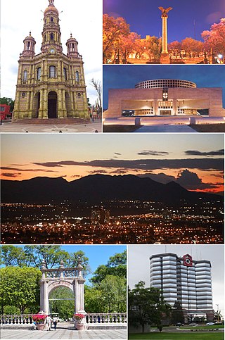
Aguascalientes ) is the capital of the Mexican state of Aguascalientes and its most populous city, as well as the head of the Aguascalientes Municipality; with a population of 934,424 inhabitants in 2012 and 1,225,432 in the metro area. The metropolitan area also includes the municipalities of Jesús María and San Francisco de los Romo. It is located in North-Central Mexico, which roughly corresponds to the Bajío region (Lowlands) within the central Mexican plateau. The city stands on a valley of steppe climate at 1880 meters above sea level, at 21°51′N102°18′W.

Aguascalientes ; lit. 'Hot Springs'), officially the Free and Sovereign State of Aguascalientes, is one of the 32 states which comprise the Federal Entities of Mexico. At 22°N and with an average altitude of 1,950 m (6,400 ft) above sea level it is predominantly of semi-arid climate. The state is located in west-central Mexico and is located in the northern part of the Bajío region, which is in the north-central part of the country, bordered by Zacatecas to the north, east and west, and by Jalisco to the south.

Coahuila y Tejas, officially the Estado Libre y Soberano de Coahuila y Tejas, was one of the constituent states of the newly established United Mexican States under its 1824 Constitution.

José María de los Dolores Francisco Germán del Espíritu Santo Bocanegra y Villalpando was a Mexican lawyer and statesman who was briefly interim president of Mexico on December, 1829 during a coup attempt against president Vicente Guerrero. He previously served in various government positions, including President of the Chamber of Deputies and as a member of the Chamber of Deputies for Zacatecas.
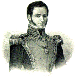
José María de Tornel y Mendívil (1795–1853) was a 19th-century creole Mexican army general and politician who greatly influenced Mexico’s political stage and the career of President Antonio López de Santa Anna.

Municipalities are the second-level administrative divisions of Mexico, where the first-level administrative division is the state. They should not be confused with cities or towns that may share the same name as they are distinct entities and do not share geographical boundaries. As of January 2021, there are 2,454 municipalities in Mexico, excluding the 16 boroughs of Mexico City. If all 16 boroughs of Mexico City is counted, the total of municipalities will be 2,470.
Mexico has experienced many changes in territorial organization during its history as an independent state. The territorial boundaries of Mexico were affected by presidential and imperial decrees. One such decree was the Law of Bases for the Convocation of the Constituent Congress to the Constitutive Act of the Mexican Federation, which determined the national land area as the result of integration of the jurisdictions that corresponded to New Spain, the Captaincy General of Yucatán, the Captaincy General of Guatemala and the autonomous Kingdoms of East and West. The decree resulted in the independence from Spain.

Events in the year 1835 in Mexico.
Events in the year 1839 in Mexico.

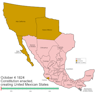
The First Mexican Republic, known also as the First Federal Republic, was a federated republic, established by the Constitution of 1824, the first constitution of independent Mexico. It was officially designated the United Mexican States. The First Mexican Republic lasted from 1824 to 1835, when conservatives under Antonio López de Santa Anna transformed it into a unitary state, the Centralist Republic of Mexico.

Events in the year 1836 in Mexico.

Events in the year 1847 in Mexico.

The Rebellion in Zacatecas of 1835 was part of the Mexican Federalist War between Mexican centralists and federalists during the first half of the nineteenth century during the administration of Antonio Lopez de Santa Anna.
In the history of Mexico, the Plan of Veracruz was a proclamation released on January 2, 1832, by the military garrison of Veracruz. The initial goal was simply to remove unpopular ministers from the cabinet of President Anastasio Bustamante, but later expanded into a year-long civil war within the First Mexican Republic that ended with the ousting of Bustamente and the recognition of Manuel Gómez Pedraza as president.

Luis Moya is a municipality in the Mexican state of Zacatecas, located approximately 50 kilometres (31 mi) southeast of the state capital of Zacatecas City. It is named after Luis Moya (1855–1911), a colonel in the Mexican Revolution who was posthumously given the rank of brigadier general in 1939.

José Refugio Reyes Rivas was a Mexican architect, author of some of the most representative buildings of the city of Aguascalientes, where his work is considered part of the historical and architectural heritage. Reyes did not have professional architectural studies, so he is called "empirical architect". In 1985 he received the post mortem title of architect, granted by the Autonomous University of Aguascalientes. Reyes completed more than 200 buildings in the states of Zacatecas, Jalisco and Aguascalientes. He was characterized by his use of diverse decorative styles, from neoclassical to Art Nouveau, as well as construction innovations of the first half of the 20th century.

Revolts Against the Centralist Republic of Mexico proliferated after the fall of the First Mexican Republic in 1835, and would continue to agitate the Centralist Republic through its entire existence, until succeeding and having the Constitution of 1824 finally restored in 1846.
