
Val-d'Isère, nicknamed Valdi, is a commune of the Tarentaise Valley, in the Savoie department in southeastern France. It lies 5 km (3 mi) from the border with Italy. It is on the border of the Vanoise National Park created in 1963, with good transport links in and out of Lyon, Geneva and Chambéry.

La Plagne is a French ski area in the alpine valley of the Tarentaise (Savoie). Since 2003, La Plagne and the neighbouring resort of Les Arcs form Paradiski's ski area. It is currently owned by Compagnie des Alpes.
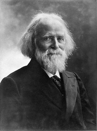
Jacques Élisée Reclus was a French geographer, writer and anarchist. He produced his 19-volume masterwork, La Nouvelle Géographie universelle, la terre et les hommes, over a period of nearly 20 years (1875–1894). In 1892 he was awarded the Gold Medal of the Paris Geographical Society for this work, despite having been banished from France because of his political activism.

The arrondissement of Albertville is an arrondissement of France in the Savoie department in the Auvergne-Rhône-Alpes region. It has 69 communes. Its population is 111,751 (2016), and its area is 2,466.1 km2 (952.2 sq mi).

Vanoise National Park is a French national park between the Tarentaise and Maurienne valleys in the French Alps, containing the Vanoise massif. It was created in 1963 as the first national park in France.
The Arve Valley is an alpine valley located in the French Haute-Savoie department. The namesake of the valley is the river at the bottom: the Arve. The valley as a whole makes up the majority of Faucigny, one of the Natural Regions of France, and one of six that make up the Savoie region.

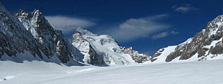
The Vanoise massif is a mountain range of the Graian Alps, located in the Western Alps. After the Mont Blanc Massif and the Écrins Massif it is the third-highest massif in France, reaching a height of 3,885 m at the summit of Grande Casse. It lies between Tarentaise Valley to the north and the Maurienne Valley in the south. The range is the site of France's first national park, established in 1963, Vanoise National Park. The ski resorts of Tignes and Val-d'Isère and the 2,770-metre-high Col de l'Iseran are located in the eastern part of the range.
Charles Henri Marie Flahault was a French botanist, among the early pioneers of phytogeography, phytosociology, and forest ecology. The word relevé for a plant community sample is his invention.

Prads-Haute-Bléone is a commune in the Alpes-de-Haute-Provence department and in the Provence-Alpes-Côte d'Azur region in southeastern France.

Pralognan-la-Vanoise or simply Pralognan is an alpine commune in the Savoie department in the Auvergne-Rhône-Alpes region in Southeastern France. In 2019, it had a population of 715. The commune is located within Vanoise National Park.

The Greek community in France numbers around between 35,000 - 50,000 people. They are located all around the country but the main communities are located in Paris, Marseille and Grenoble.
Louis Lliboutry was a French glaciologist, geophysicist, and mountaineer. While in Chile in the early 1950s, he analysed and explained the formation of snow penitents in the Andes, which marked his first contribution to glaciology. He founded in Grenoble in 1958 the Laboratory of Alpine Glaciology and headed it for 25 years; he also set up at that period a pioneering syllabus in geophysics. His contributions to mechanics of viscous media and to geodynamics are internationally acknowledged.
Denis Retaillé was a Professor of Geography at the University of Bordeaux III and the Director of the CNRS ADES Research Unit, UMR 5186. Professor Retaillé holds a PhD in Geography from the University of Rouen (1983) dedicated to the study of the Nigerien region of Koutous, and an Habilitation from the Paris-Sorbonne University (1993) dedicated to the study of space in the Sahel. From 1993 to 2008, Denis Retaillé was a Professor of Geography at the University of Rouen, France.
The Glacier Blanc is a glacier in the French département of Hautes-Alpes. Its name derives from the fact that – unlike the nearby Glacier Noir – its surface appears pristinely white due to an absence of morainic debris.

The Glacier Noir is a glacier in the Massif des Écrins in the French Alps. It is located in the département of Hautes-Alpes.
Raoul Blanchard was a French geographer. He taught at the University of Grenoble from 1906 and devoted most of his research to Alpine and Canadian geography.
Thérèse Sclafert, possibly born Jeanne Sclafert was a French historian and geographer.
Pierre Léon was a French historian.
Germaine Veyret-Verner was a French geographer and one of the first female university professors in France, known for her work on the Alps, her role in the development of geography and her international recognition relating to the Institut de géographie alpine in Grenoble and the Revue de géographie alpine.
Numa Broc, born on 26 January 1934, in Versailles and died in Perpignan on 12 March 2017, was a French geographer, specialising in the history and epistemology of geography.

