Related Research Articles
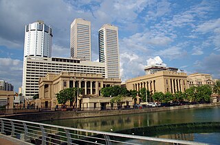
Colombo is the executive and judicial capital and largest city of Sri Lanka by population. According to the Brookings Institution, the Colombo metropolitan area has a population of 5.6 million, and 752,993 in the Municipality. It is the financial centre of the island and a tourist destination. It is located on the west coast of the island and adjacent to the Greater Colombo area which includes Sri Jayawardenepura Kotte, the legislative capital of Sri Lanka, and Dehiwala-Mount Lavinia. Colombo is often referred to as the capital since Sri Jayawardenepura Kotte is itself within the urban/suburban area of Colombo. It is also the administrative capital of the Western Province and the district capital of Colombo District. Colombo is a busy and vibrant city with a mixture of modern life, colonial buildings and monuments.
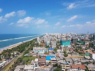
Dehiwala-Mount Lavinia, population 245,974 (2012), is a large municipality in Sri Lanka, covering 2,109 ha. It lies south of the Colombo Municipal Council area and is separated from it by the Dehiwala canal which forms the northern boundary of DMMC. Its southern limits lie in Borupana Road and the eastern boundary is Weras Ganga with its canal system and it includes some areas to its east. This town has experienced extensive population growth and rapid industrialisation and urbanisation in recent years. It is home to Sri Lanka's National Zoological Gardens, which remains one of Asia's largest. Colombo South Teaching Hospital, Kalubowila and Colombo Airport, Ratmalana are some important landmarks in this area. Dehiwela-Mount Lavinia and Sri Jayawardenapura Kotte being two large suburban centres of the city of Colombo function together as one large urban agglomeration in the Region. The overspill from the City in residential and commercial uses of land has rapidly urbanised these suburban centres. Dehiwela-Mount Lavinia and Sri Jayawardenpaura along with Colombo Municipal Council form the most urbanised part of the core area of the Colombo Metropolitan Region. Dehiwala and Mount Lavinia lie along the Galle Road artery, which runs along the coast to the south of the country.

Hinduism is one of Sri Lanka's oldest religions, with temples dating back over 2,000 years. As of 2011, Hindus made up 12.6% of the Sri Lankan population. They are almost exclusively Tamils, except for small immigrant communities from India and Pakistan.
Bambalapitiya is a southern coastal neighbourhood of Colombo, Sri Lanka.

Negombo is a major city in Sri Lanka, situated on the west coast and at the mouth of the Negombo Lagoon, in the Western Province, 38 km (24 mi) from Colombo via the Colombo–Katunayake Expressway and the nearest major city from the Bandaranaike International Airport.
Minjur is a town located in the outskirts of North Chennai, India. It is located in Thiruvallur district in the Indian state of Tamil Nadu. Minjur is called 'Vada Kanchi' meaning North Kanchipuram. The town has two famous temples for Shiva and Vishnu, similar to Kanchipuram. The neighbourhood is served by Minjur railway station of the Chennai Suburban Railway Network.

Velanai is a small village in Velanai Island off the coast of Jaffna Peninsula in the North of Sri Lanka.
Kayts, is one of the important small island off the coast of the Jaffna Peninsula in northern Sri Lanka. There are a number of other villages within the Kayts Island such as Allaippiddi, Mankumpan, Velanai, Saravanai, Puliyankoodal, Suruvil, Naranthanai, Karampon and Melinchimunai.
Chunnakam is a town, located 9.7 km (6.0 mi) north of Jaffna. It is one of the important commercial centres in Jaffna. The original name of the town was Mayilani. In northern Sri Lanka, Chunnakam is only second to Jaffna in terms of population density and commercial activities in and around its neighbourhoods.
Wellawatta is a neighbourhood of Colombo, Sri Lanka. It lies immediately south of Bambalapitiya and is classified as zone 6 within the Colombo Municipal region. The town begins at the old Dutch canal just before the Savoy Cinema and extends south to the same canal that reaches the sea just before the junction at Hospital Road where Dehiwela begins. It is bounded on the west by the waters of the Indian Ocean and extends to Pamankada where Havelock Road forks and meets the Sri Saranankara Road bridge, which stretches over the Dutch canal, extending towards Kohuwala-Hospital Road junction on Dutugemunu Street.
Maradana is a suburb of Colombo, Sri Lanka. Maradana is the site of Maradana Railway Station, one of the primary railway hubs in the country, serving intercity rail and commuter rail. Maradana also has many railway yards and running sheds. A technical college, many national schools, the Lotus Tower, and business institutions are also located in the area.
Mabola or Mabole is a town and Urban Council in Gampaha District in the Western Province of Sri Lanka. With Wattala it forms Wattala–Mabola urban council. It is located in Negombo road and it is the route for travel to Bandaranaike International Airport. The newly constructed, Sri Lanka's second E Class highway, Colombo - Katunayake Expressway E03 crosses to the seaside through Mabola.
Grandpass is a suburb in Colombo, Sri Lanka. It is part of an area known as Colombo 14.
Chilaw is a city in Puttalam District, North Western Province, Sri Lanka. It is governed by an urban council, whereas the outskirts are governed by a pradeshiya sabha of the same name. The town is located 80 kilometers away from Colombo via Negombo.
Colombo Central electoral district was an electoral district of Sri Lanka between August 1947 and February 1989. The district was named after the city of Colombo in Colombo District, Western Province. The district was one of three multi-member constituencies, with three members, the others were Balangoda and Kadugannawa. was a three-member constituency. The 1978 Constitution of Sri Lanka introduced the proportional representation electoral system for electing members of Parliament. The existing 160 mainly single-member electoral districts were replaced with 22 multi-member electoral districts. Colombo Central electoral district was replaced by the Colombo multi-member electoral district at the 1989 general elections, the first under the PR system, though Colombo Central continues to be a polling division of the multi-member electoral district.

Udappu or Udappuwa is a traditional Tamil fishing, goldsmithing and shrimp farming village, situated 65 miles (105 km) north of Colombo the capital of Sri Lanka in the North Western Province. It is situated few miles north of Chilaw city and Munneswaram temple.
Rajakeeya Mawatha is a street in Colombo, Sri Lanka, named after Royal College Colombo, whose grounds border it on the southern side. Located in the prominent residential area of Cinnamon Gardens in Colombo 7, it is home to many notable residents and old mansions.
Moors Sports Club Ground is a first-class cricket ground in Colombo, the home ground of the Moors Sports Club.

Araly is a town in Northern Jaffna District, Sri Lanka. It is located 8.6 km (5.34 mi) North West from the city of Jaffna. It is bordered by sea on both sides and surrounded by villages like Ponnalai, Moolai, Vaddukoddai, Sankarathai and Navali. During the Sri Lankan Civil War, the rebel Liberation Tigers of Tamil Eelam (LTTE) occupied Araly in 1986. The Indian Peace Keeping Force (IPKF) briefly occupied the city in 1987. The LTTE again occupied the village from 1989 until 1995, when the Sri Lankan Army regained control.
References
- ↑ "Aishwarya Lakshmi Amman Temple, Western, Sri Lanka". placesmap.net. Retrieved 9 December 2018.
- ↑ "🕗 Sri Ishwaryaluxmi Thirukkovil Colombo opening times, Ramakrishna Road, tel. +94 112 360 525". Near Place. Retrieved 9 December 2018.
6°51′54″N79°51′44″E / 6.86509°N 79.86210°E
| | This article about an Indian religious building or structure is a stub. You can help Wikipedia by expanding it. |