Lae is the capital of Morobe Province and is the second-largest city in Papua New Guinea. It is located near the delta of the Markham River and at the start of the Highlands Highway, which is the main land transport corridor between the Highlands Region and the coast. Lae is the largest cargo port of the country and is the industrial hub of Papua New Guinea. The city is known as the Garden City and home of the University of Technology.

The Gulf of Papua is located in the southern coast region of New Guinea. It has a total surface area of 70,400 km2 (27,200 sq mi).
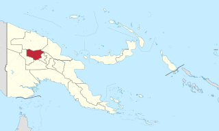
Enga is one of the provinces in Papua New Guinea (PNG). It is located in the north most region of the highlands of PNG, having been divided from the Western Highlands to become a separate province when the provinces were created at the time of independence in 1975. The people of Enga are called Engans—they are a majority ethnic group—speaking one language in all its five districts: approximately 500,000 people. A small minority of Engans' land on the eastern side of the region remained in the Western Highlands, their territory being accessible by road from Mount Hagen but not directly from elsewhere in Enga territory.

Ukarumpa is an intentional international community that is the main centre for SIL-PNG, located in the Eastern Highlands Province of Papua New Guinea. It lies approximately 11 kilometres (7 mi) by road from Kainantu in the Aiyura Valley. The population consists of a variety of paid staff and volunteer staff who live nearby. The centre was established in 1957. The current population is approximately 600. It is at an elevation of approximately 1600 m above sea level.
Ukarumpa International School is an accredited PreK-12 school in Ukarumpa, Papua New Guinea.
Kainantu is a town in the Eastern Highlands of Papua New Guinea. It had some historical significance as an airstrip town during WWII. It functions primarily as a market town for local produce growers and cash croppers. It is located on the "Highlands Highway" approximately 170 kilometres (110 mi) by road from Lae and 90 kilometres (56 mi) by road from Goroka. It is 11 kilometres (6.8 mi) approx from a nearby missionary station Ukarumpa and is nearby the Aiyura valley. Kainantu has basic facilities such as a school, hospital, police station, district court, and service stations.

Eastern Highlands is a highlands province of Papua New Guinea. The provincial capital is Goroka. The province covers an area of 11,157 km², and has a population of 579,825. The province shares a common administrative boundary with Madang Province to the north, Morobe Province to the east, Gulf Province to the south, and Simbu Province to the west. The province is the home of the Asaro mud mask that is displayed at shows and festivals within the province and in the country. It is reachable by air and road transport.

Mount Hagen is the third largest city in Papua New Guinea, with a population of 46,250. It is the capital of the Western Highlands Province and is located in the large fertile Wahgi Valley in central mainland Papua New Guinea, at an elevation of 1,677 m (5,502 ft).

Aiyura Airport is an airstrip in Aiyura, in the Eastern Highlands Province of Papua New Guinea. It is the main air field for Summer Institute of Linguistics (SIL). The pilots and mechanics who work out of Aiyura Airport live in the nearby SIL town of Ukarumpa.

Kericho is the biggest town in Kericho County located in the highlands west of the Kenyan Rift Valley. Standing on the edge of the Mau Forest, Kericho has a warm and temperate climate making it an ideal location for agriculture and in particular, the large scale cultivation of tea.
Kuk Swamp is an archaeological site in Papua New Guinea, that lies in the Wahgi Valley of the highlands. The swamp developed in a former lake basin, as it was filled by an alluvial fan or deposits of water-transported material. Archaeological evidence for early agricultural drainage systems was found here, beginning about 9,000 years ago. It includes draining ditches of three major classes, which were used to convert the area to an anthropogenic grassland. The native crop taro was grown here.
Aquaculture in Papua New Guinea is a developing industry, despite having been first introduced to the country in the 1960s. The only forms of traditional aquaculture in Manus Island and fish culture on Bougainville Island. Numerous attempts to introduce both marine and freshwater aquaculture in Papua New Guinea have been unsuccessful. Currently, the main freshwater facility for aquaculture is the Highlands Aquaculture Development Center in Aiyura.

Coffee production in Papua New Guinea is the country's second largest agricultural export, after oil palm, and employs approximately 2.5 million people. It accounts for approximately 1% of world production, according to the United Nations Conference on Trade and Development (UNCTAD).
Kerevat is a town and seat of Gazelle District in East New Britain Province, on the island of New Britain, Papua New Guinea. It is home to a prison, the Kerevat National High School, the Kerevat Education Centre, and the Cocoa and Coconut Research Institute. Its principal crop is cocoa. An airfield was constructed here by the Imperial Japanese in World War II during September 1943.
Taraka is a suburb of Lae in the Morobe Province, Papua New Guinea. The main campus for the Papua New Guinea University of Technology is located in Taraka.
9 Mile is a large village in the Markham Valley of Morobe Province, Papua New Guinea. It lies along the Highlands Highway 9 miles (14 km) from the center of Lae between the foothills of the Atzera Range and the Markham River. The Atzera Range starts at Bugandi and runs adjacent to the Markham River has an elevation of 280 meters above sea level. northwest of Lae, 7 kilometres (4.3 mi) southeast of Nadzab. The landscape is typically lowland rainforest.
Salome Dell is an athlete from Papua New Guinea. She has represented her country at two Commonwealth Games and is considered Papua New Guinea's most successful middle-distance athlete.

Kainantu Urban LLG is a local-level government (LLG) of Eastern Highlands Province, Papua New Guinea. Ukarumpa, an important SIL International base in Papua New Guinea, is located in the LLG.
Aiyura National High School is one of six government-run national high schools in Papua New Guinea (PNG), now known as "schools of excellence". Situated in the Eastern Highlands Province, it is a boarding school for Grades 11 and 12, and its students come from all over PNG.
