
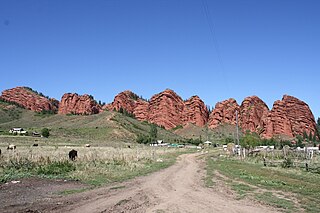
Batken Region is a region (oblast) of Kyrgyzstan. Its capital is Batken. It is bounded on the east by Osh Region, on the south, west and north by Tajikistan, and on the northeast by Uzbekistan. The northern part of the region is part of the flat, agricultural Ferghana Valley. The land rises southward to the mountains on the southern border: the Alay Mountains in the east, and the Turkestan Range in the west.

Osh Region is a region (oblast) of Kyrgyzstan. Its capital is Osh. It is bounded by (clockwise) Jalal-Abad Region, Naryn Region, Xinjiang, China, Tajikistan, Batken Region, and Uzbekistan.

Kyzyl-Kiya is a city in Batken Region, in southwestern Kyrgyzstan. Its area is 78 square kilometres (30 sq mi), and its resident population was 44,144 in 2009. It is situated on the southern edge of the Fergana Valley, 32 km southeast of Fergana, and 65 km southwest of Osh. The town is one of the oldest centers of the coal mining industry in Kyrgyzstan.
Ak-Turpak is a village in Batken Region of Kyrgyzstan. Its population was 471 in 2009.

Batken is a raion (district) of Batken Region in south-western Kyrgyzstan. Its area is 5,948 square kilometres (2,297 sq mi), and its resident population was 69,591 in 2009. The capital lies at Batken.

Leilek is a raion (district) of Batken Region in south-western Kyrgyzstan. It borders with Batken District in the east, and Tajikistan in the south, west, and north. Its area is 4,653 square kilometres (1,797 sq mi), and its resident population was 116,861 in 2009. The capital lies at Isfana.

Jayyl is a raion (district) of Chuy Region in northern Kyrgyzstan. Its area is 3,453 square kilometres (1,333 sq mi), and its resident population was 92,645 in 2009. The capital lies at Kara-Balta. It also administers an exclave in the southwestern heel of Chuy Region, separated from the rest of the Jayyl District by the Panfilov District.

Moskva is a raion (district) of Chuy Region in northern Kyrgyzstan. Its area is 2,056 square kilometres (794 sq mi), and its resident population was 84,443 in 2009. The capital lies at Belovodskoye.

Ak-Suu is a raion (district) of Issyk-Kul Region in eastern Kyrgyzstan. The administrative center lies at the village Ak-Suu. Its area is 9,917 square kilometres (3,829 sq mi), and its resident population was 63,686 in 2009.
Jeti-Ögüz or Jeti-Oguz is a raion (district) of Issyk-Kul Region in north-eastern Kyrgyzstan. The capital lies at Kyzyl-Suu, Its area is 14,499 square kilometres (5,598 sq mi), and its resident population was 82,085 in 2009. and the province comprises much of the eastern end of the Teskey Ala-Too Range.

Tüp is a raion (district) of Issyk-Kul Region in north-eastern Kyrgyzstan. The capital lies at Tyup. Its area is 2,121 square kilometres (819 sq mi), and its resident population was 58,786 in 2009. It borders Issyk Kul District to the west, Ak-Suu District to the east and south-east, Kazakhstan to the north, and Issyk Kul to the south.
Aksy is a raion (district) of Jalal-Abad Region in western Kyrgyzstan. The capital lies at Kerben. Its area is 4,578 square kilometres (1,768 sq mi), and its resident population was 113,010 in 2009.

At-Bashy is a raion (district) of Naryn Region in Kyrgyzstan. The administrative center is at At-Bashy. Its area is 15,354 square kilometres (5,928 sq mi), and its resident population was 49,238 in 2009.

Kochkor is a raion (district) of Naryn Region in northern-central Kyrgyzstan. The capital lies at Kochkor. Its area is 5,868 square kilometres (2,266 sq mi), and its resident population was 58,267 in 2009.
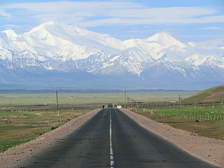
Alay is a raion (district) of Osh Region in south-western Kyrgyzstan. The capital lies at Gul'cha. The Alay District borders with China in the east, Tajikistan in the south, Chong-Alay District in the west, Nookat District in the north-west, Kara-Suu District and Uzgen District in the north, and Kara-Kulja District in the north-east. Its area is 6,821 square kilometres (2,634 sq mi), and its resident population was 72,170 in 2009.

Kara-Suu is a raion (district) of Osh Region in south-western Kyrgyzstan. Its area is 3,616 square kilometres (1,396 sq mi), and its resident population was 348,645 in 2009. The capital lies at Kara-Suu.

The Ak-Suu is a left tributary of the Syr Darya, flowing through Batken Province of Kyrgyzstan and Sughd Province of Tajikistan. The river is formed at the north slopes of Turkestan Range. It flows into the river Syr Darya near the town Nau in northern Tajikistan. The main settlements on the river are the village Ak-Suu in Kyrgyzstan and the town Nau in Tajikistan.
Ak-Suu may refer to the following places in Kyrgyzstan:


