
The Waipā River is in the Waikato region of the North Island of New Zealand. The headwaters are in the Rangitoto Range east of Te Kūiti. It flows north for 115 kilometres (71 mi), passing through Ōtorohanga and Pirongia, before flowing into the Waikato River at Ngāruawāhia. It is the Waikato's largest tributary. The Waipā's main tributary is the Puniu River.

The Buller River is a river in the South Island of New Zealand. The Buller has the highest flow of any river in the country during floods, though it is only the 13th longest river; it runs for 177 km (110 mi) from Lake Rotoiti through the Buller Gorge and into the Tasman Sea near the town of Westport. A saddle at 710 m (2,330 ft) separates the Buller from the Motupiko River and that is divided from the Wairau River by a 695 m (2,280 ft) saddle, both aligned along the Alpine Fault, as is the top of the Buller valley.

The Ashley River is in the Canterbury region of New Zealand. It flows generally southeastwards for 65 kilometres (40 mi) before entering the Pacific Ocean at Waikuku Beach, Pegasus Bay north of Christchurch. The town of Rangiora is close to the south bank of the Ashley River. The river's official name was changed from Ashley River to the dual name Ashley River / Rakahuri by the Ngāi Tahu Claims Settlement Act 1998.

The Stillwater Ngākawau Line (SNL), formerly the Stillwater–Westport Line (SWL) and the Ngakawau Branch, is a secondary main line, part of New Zealand's national rail network. It runs between Stillwater and Ngakawau via Westport on the West Coast of the South Island. It was one of the longest construction projects in New Zealand's history, with its first section, at the south end, opened in 1889, and the beginnings of the Ngākawau Branch, at its Westport end, in 1875. The full line was completed in 1942. The only slower railway projects were Palmerston North to Gisborne, 1872 to 1942, and the Main North Line to Picton, 1872 to 1945.

Seddonville is a lightly populated locality on the West Coast of New Zealand's South Island. It is most famous for the historical role it played in New Zealand's coal mining industry.

Waikato County was one of the counties of New Zealand on the North Island. Under the Local Government Reorganisation Order of 1989, nearly all of the county was added to the boroughs of Huntly, Ngāruawāhia, most of Raglan County Council, and a small part of Waipa County Council, to form Waikato District Council.
Clutha County was one of the counties of New Zealand in the South Island. Its first meeting was on 4 January 1877 at the Balclutha courthouse. The offices on the corner of Clyde and Elizabeth Streets in Balclutha were rebuilt in 1934 and demolished in 2009. Clutha District Council began in November 1989 with amalgamation of Balclutha Borough, Clutha County, Lawrence Borough, Tapanui Borough, part of Tuapeka County and Bruce District Council. Bruce District Council had been formed in 1986 from Bruce County, Milton Borough and Kaitangata Borough.

Ashburton County was one of the counties of New Zealand in the South Island. The council first met on 4 January 1877 in the Ashburton Road Board office. It became part of Ashburton District Council in 1989, together with Ashburton Borough Council.
Otautau is a small farming, forestry and milling town located inland on the western edge of the Southland Plains of New Zealand on the banks of the Aparima River. Otautau is located approximately 40 kilometres (25 mi) north west of Invercargill. The average elevation of Otautau is 60 metres.
William Arthur Greener Penlington was a New Zealand school principal and educationalist.

Te Horo railway station was a flag station at Te Horo, in the Kāpiti Coast District on the North Island Main Trunk in New Zealand.It was served by diesel shuttles between Te Horo and Wellington. Only equipment sheds and a passing loop now remain at the station site.

The Northern Steam Ship Company Ltd (NSS) served the northern half of the North Island of New Zealand from 1881 to 1974. Its headquarters, the Northern Steam Ship Company Building, remains in use on Quay Street, Auckland as a bar and is listed by Heritage New Zealand as a Category I Historic Place.
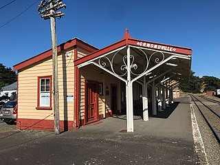
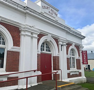
Ormondville is a locality in the Manawatū-Whanganui region of New Zealand's North Island. It is located inland, south of Waipukurau and west of Flemington, Hawke's Bay.

SS Go Ahead was a twin screw-steamer, launched on the afternoon of Saturday 20 April 1867 by Seath and Connell, of Rutherglen, for the Clyde Shipping Company, with a plan to use her in New Zealand coastal trading. She had 30, or 35 hp (26 kW), high pressure engines, and tubular boilers from Campbell & Son's foundry.
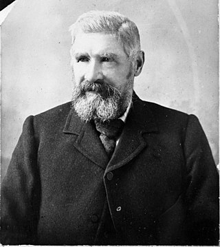
Isaac Coates (1840–1932) was mayor of Hamilton, New Zealand, from 1888 to 1892, a farmer, flax-miller, and a drainage and railway contractor.

Opaparailway station is a preserved station on the Palmerston North–Gisborne Line in New Zealand's North Island that closed in 1981. It is in the Hastings District of Hawke's Bay, 23.56 km (14.64 mi) south of Hastings city, in a census meshblock with a population of only 222 in 2018.
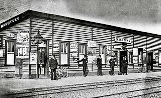
Makotuku is a locality in the Manawatu-Whanganui Region of New Zealand's North Island, about 3 km2 (1.2 sq mi) west of Ormondville.
Hatuma is 7 km (4.3 mi) south of Waipukurau, in Central Hawke's Bay in the east of the North Island of New Zealand. Meshblock 7016748, which covers 19.3 km2 (7.5 sq mi) from the edge of Waipukurau to Marakeke, had a population of 153 in 2018.
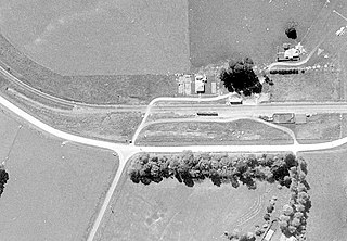
Kopua in New Zealand is now a sparsely populated area, immediately south of the border of the Manawatū-Whanganui and Hawke's Bay regions, with 150 people scattered over a 40 km2 (15 sq mi) meshblock. For two years it briefly flourished as a village, centred on a railway station on the Palmerston North–Gisborne line, opened on 25 January 1878, when it became the southern terminus of the line from Napier and Spit. Building to the south was delayed by the need to erect 3 large viaducts over the Manawatū River and its tributaries, so the extension to Makotuku didn't open until 9 August 1880. Kopua then declined until the station closed on 8 May 1977. Only a single line now passes through the station site and there are remnants of cattle yards.
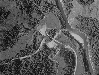
Newton River in the Tasman District ), flows west and then south for about 20 km (12 mi) from Mount Newton to the Buller River, 17 km (11 mi) west of Murchison. Near its mouth it is crossed by SH6 on a steel truss bridge with a 120 ft (37 m) main span and two 30 ft (9.1 m) side spans.
