Related Research Articles

Lowestoft is a coastal town and civil parish in the East Suffolk district of Suffolk, England. As the most easterly UK settlement, it is 110 miles (177 km) north-east of London, 38 miles (61 km) north-east of Ipswich and 22 miles (35 km) south-east of Norwich, and the main town in its district. The estimated population in the built-up area exceeds 70,000. Its development grew with the fishing industry and as a seaside resort with wide sandy beaches. As fishing declined, oil and gas exploitation in the North Sea in the 1960s took over. While these too have declined, Lowestoft is becoming a regional centre of the renewable energy industry.

Somerleyton is a village and former civil parish in the north of the English county of Suffolk. It is 4.5 miles (7.2 km) north-west of Lowestoft and 5.5 miles (8.9 km) south-west of Great Yarmouth in the East Suffolk district. The village is closely associated with Somerleyton Hall and was largely rebuilt as a model village in the 19th century at the direction of Samuel Morton Peto. The parish was combined with Herringfleet and Ashby to create the parish of Somerleyton, Ashby and Herringfleet in 1987.

Carlton Colville is a civil parish and suburb of Lowestoft in the English county of Suffolk. It is 3 miles (5 km) south-west of the centre of the town, in the East Suffolk district. The area lies along the A146 Lowestoft to Beccles road.

Corton is a village and civil parish in the north of the English county of Suffolk. It is 3 miles (4.8 km) north of the centre of Lowestoft in the East Suffolk district. The village is on the North Sea coast with the county border with Norfolk to the north. It is a seaside holiday centre, with a number of facilities for visitors. Great Yarmouth is 6 miles (9.7 km) to the north.
Barnby is a village and civil parish in the East Suffolk district of the English county of Suffolk. The village is 5 miles (8.0 km) west of Lowestoft and 3 miles (4.8 km) east of Beccles in the north of the county. It is effectively merged with the village of North Cove which constitutes a separate parish.

Benacre is a village and civil parish in the East Suffolk district of the English county of Suffolk. The village is located about 5+3⁄4 miles (9 km) south of Lowestoft and 1+1⁄2 miles (2 km) north-east of Wrentham, between the main A12 road and the North Sea coast. Neighbouring villages include Kessingland and Covehithe with the town of Southwold 5 miles (8 km) to the south.

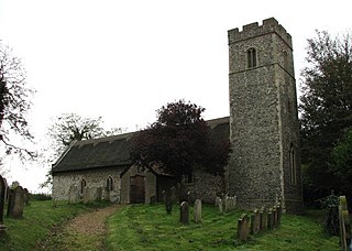
Blundeston is a village and civil parish in the north of the English county of Suffolk. It is 3.5 miles (5.6 km) north-west of Lowestoft, 6 miles (9.7 km) south of Great Yarmouth and around 1.75 miles (2.82 km) inland from the North Sea coast. It is part of the area known as Lothingland in the East Suffolk district. Blundeston Prison was located on the southern edge of the village but closed in early 2014.

Fritton is a village and former civil parish in the English county of Norfolk, situated some 9 km (5.6 mi) south-west of the town of Great Yarmouth and 11 km (6.8 mi) north-west of the Suffolk town of Lowestoft. It should not be confused with the village of the same name near Morningthorpe, also in Norfolk. In 1961 the parish had a population of 192.

Gisleham is a village and civil parish in the English county of Suffolk. It is on the edge of Lowestoft, around 4.5 miles (7.2 km) south-west of the town centre. The parish is in the East Suffolk district, situated between Carlton Colville and Kessingland.

Wissett is a village and civil parish in the English county of Suffolk. It is 2 miles (3.2 km) north-east of the market town of Halesworth in the East Suffolk district. Historically, it was in the Blything Hundred.

Kirkley is a district within the town of Lowestoft in the East Suffolk district of the English county of Suffolk. It is located south of the centre of Lowestoft and the town's harbour and Lake Lothing. Kirkley was originally an independent village but is now part of the urban conurbation of Lowestoft. In 1901 the parish had a population of 6465.

Rushmere is a village and civil parish in the East Suffolk district of the English county of Suffolk. The village is around 5 miles (8.0 km) south-west of Lowestoft and 5+1⁄2 miles (8.9 km) south-east of Beccles. Neighbouring parishes include Gisleham, Henstead with Hulver Street and Mutford. The Hundred River forms the southern boundary of the parish.

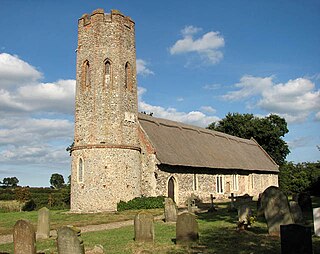
Lound is a village and civil parish in the north of the English county of Suffolk. It is 4.5 miles (7.2 km) north of Lowestoft, 5 miles (8.0 km) south of Great Yarmouth in the East Suffolk district. It is 2 miles (3.2 km) from the North Sea coast at Hopton-on-Sea and is on the border with the county of Norfolk.

Ellough is a civil parish in the East Suffolk district of the English county of Suffolk, located approximately 3 miles (5 km) south-east of Beccles. The area is sparsely populated with a mid-2005 population estimate of 40. The parish, which has an area of 4.5 square kilometres (1.7 sq mi), borders Worlingham, North Cove, Mutford, Weston, Sotterley, Willingham St Mary and Henstead with Hulver Street. The parish council operates to administer jointly the parishes of Shadingfield, Willingham St Mary, Sotterley and Ellough.

Weston is a village and civil parish in the English county of Suffolk. It is around 2 miles (3 km) south of Beccles in the East Suffolk district. The parish lies either side of the A145 road and is crossed by the Ipswich to Lowestoft railway line. Neighbouring parishes include Ellough, Ringsfield, Willingham St Mary and Shadingfield. The village is largely dispersed with a population of around 230.

Pakefield is a suburb of the town of Lowestoft in the north of the English county of Suffolk. It is located around 2 miles (3.2 km) south of the centre of the town. In 1931 the parish had a population of 1774.
Ashby is a former civil parish in the north of the English county of Suffolk. It is 5+1⁄2 miles (8.9 km) north-west of Lowestoft in the East Suffolk district. The parish was combined with Somerleyton and Herringfleet to form the combined parish of Somerleyton, Ashby and Herringfleet in 1987.

North Cove is a village and civil parish in the north of the English county of Suffolk. It is part of the East Suffolk district, located around 3 miles (4.8 km) east of Beccles and 5 miles (8.0 km) west of Lowestoft. It merges with the village of Barnby and the villages share some resources, although the two parishes retain separate parish councils.

Flixton is a civil parish in the north of the English county of Suffolk. It is 2 miles (3.2 km) north-east of Lowestoft in the East Suffolk district.

Oulton is a civil parish on the western edge of the town of Lowestoft in the north of the English county of Suffolk. It is in the East Suffolk district. The eastern part of the parish forms part of the suburbs of Lowestoft, whilst the western section extends into The Broads national park, reaching the River Waveney and Oulton Dyke.
References
- ↑ Akethorpe, Domesday Book Online. Retrieved 2011-04-21.
- 1 2 Akethorpe, Open Domesday. Retrieved 2021-02-19.
- ↑ Monument record LWT 028 - Akethorp Manor Bank, Suffolk Heritage Explorer, Suffolk County Council. Retrieved 2021-02-19.