
Thane district is a district in the Konkan Division of Maharashtra, India. At the 2011 Census it was the most populated district in the country, with 11,060,148 inhabitants; however, in August 2014 the district was split into two with the creation of a new Palghar district, leaving the reduced Thane district with a 2011 Census population of 11,060,148. The headquarters of the district is the city of Thane. Other major cities in the district are Navi Mumbai, Kalyan-Dombivli, Mira-Bhayander, Bhiwandi, Ulhasnagar, Ambarnath, Badlapur, Murbad and Shahapur.

Nandurbar district is an administrative district in the northwest corner of Maharashtra state in India. On 1 July 1998 Dhule was bifurcated as two separate districts now known as Dhule and Nandurbar. Nandurbar is a tribal-dominated district, The district headquarters are located at Nandurbar city. The district occupies an area of 5,955 square kilometres (2,299 sq mi) and has a population of 1,648,295 of which 16.71% were urban.

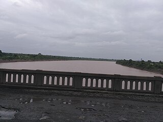
The Bhima River is a major river in Western India and South India. It flows southeast for 861 kilometres (535 mi) through Maharashtra, Karnataka, and Telangana states, before joining the Krishna River. After the first sixty-five kilometers in a narrow valley through rugged terrain, the banks open up and form a fertile agricultural area which is densely populated.
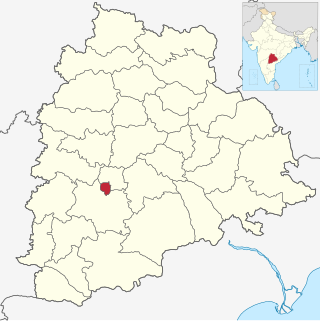
Hyderabad district is a district in the state of Telangana in India that contains a part of the metropolitan area of Hyderabad. It is headed by a district collector who is drawn from the IAS cadre and is appointed by the state government. It is the smallest of all the districts in the state, but has the highest human density. Old MCH area, which is central region of Hyderabad city comes under this district.The district share boundaries with Rangareddy and Medhchal districts.

Bilagi is a panchayat town and taluka in the Bagalkot district of Karnataka, India. It is located at a distance of 30 km from the district headquarters of Bagalkote. The main occupation of people in this taluka is agriculture. Most of the farmers grow sugarcane.
Alot is a town and nagar panchayat in the Ratlam district of Madhya Pradesh, India. The name of Alot is derived from King Alia Bhil who established this region.
Soegaon or Soyagav is a town and a Taluka in Aurangabad district in the state of Maharashtra, India. It is the headquarter of Soegaon Taluka and located in base of Ajanta hills on Chhatrapati sambhajinagar- Jalgaon Highway in western India. The city is about 120 km from Aurangabad and 60 km from Jalgaon. It is a fast developing city in Aurangabad which has many historical places and scenery like Ajanta Caves, Ghatotkach fort, Vadi fort, Vetalvadi dam, etc.
Sangameshwar Taluka is a taluka in Ratnagiri subdivision of Ratnagiri district in the Indian state of Maharashtra. The headquarters for the taluka is the town of Devrukh. In Sangameshwar the two rivers Sonavi and Shastri flow together. The meaning of Sangama in Marathi is "confluence," and so the name "Sangameshwar". It is historically important as the place where Chhatrapati Sambhaji, son of Chhatrapati Shivaji was captured by Mughal Emperor Aurangzeb. Chhatrapati Sambhaji was tortured and executed in Tulapur.

The Manjara River is a tributary of the river Godavari. It passes through the states of Maharashtra, Karnataka and Telangana. It originates in the Balaghat range of hills near the Ahmednagar district at an altitude of 823 metres (2,700 ft) and empties into the Godavari River. It has a total catchment area of 30,844 square kilometres (3,084,400 ha). This river is one of the Triveni Sangam.
The Painganga River is the chief river of the Buldhana district, Hingoli district, Nanded district, Yavatmal district, Chandrapur district and Washim district in the Maharashtra state in India. It flows along the southeast boundaries of the district in a winding, meandering course. It is deeply entrenched and difficult to navigate. It rises in the Ajantha range and is a major tributary of the Wardha River, the other major river in the district. It is also divided Marathwada and Vidarbha near Umarkhed and Himayatnagar.
Samaro is a tehsil in the Sindh province of Pakistan. The town is the headquarters of a tehsil of Umarkot District.

Pondataluka is a subdivision of the district of north Goa, in the Indian state of Goa. Its administrative headquarters is the township of Ponda.
Sarangkheda is a village in Shahada taluka in Nandurbar district of Maharashtra state in India. Sarangkheda village is situated around 15 km South of Shahada on the bank of Tapti River.
Akkalkuwa Assembly constituency is one of the 288 Vidhan Sabha constituencies of Maharashtra state in western India. This constituency is located in the Nandurbar district and it is reserved for the candidates belonging to the Scheduled tribes. It is currently held by Adv. K. C. Padvi of the INC, who is currently Cabinet Minister for Tribal Affairs.
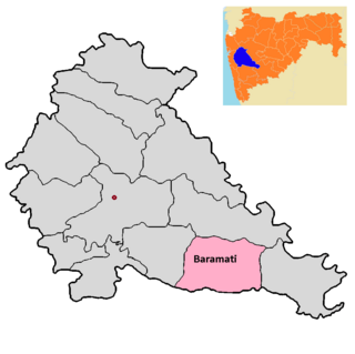
Baramati taluka is a taluka in Baramati subdivision of Pune district of state of Maharashtra in India.

Dhom Dam is an earthfill and gravity dam on Krishna River near Wai in state of Maharashtra in India.
Kukarmunda is one of the seven Talukas that form the Tapi district of Gujarat. It is located by the Tapi river basin, south of the Satpura hill range.
Nizar (Nijhar) is one of the 7 tehsils in Tapi district in the Indian state of Gujarat. Nizar was separated from Surat district in 2007 while Tapi district was formed. Nizar is located in the South Gujarat, about 172 km from Surat bordering Nandurbar district of Maharashtra.The official language is Gujarati.
Ulundurpettai or Ulundurpet is a municipality in Ulundurpet taluka of Kallakurichi district of Tamil Nadu, India. It is at the intersection of NH 68 and NH 45 located 205 km from Chennai and 129 km from Tiruchirappalli. Ulundurpettai itself is a Constituency for Tamil Nadu State Assembly, and is the Taluk headquarters for Ulundurpet taluka in the eastern region of Kallakurichi district, and is in Ulundurpet revenue block.
Thane taluka is a taluka in Thane district of Maharashtra state in Konkan division.
