Related Research Articles

Nunavik comprises the northern third of the province of Quebec, part of the Nord-du-Québec region and nearly coterminous with Kativik. Covering a land area of 443,684.71 km2 (171,307.62 sq mi) north of the 55th parallel, it is the homeland of the Inuit of Quebec. Almost all of the 13,181 inhabitants of the region, of whom 90% are Inuit, live in fourteen northern villages on the coast of Nunavik and in the Cree reserved land (TC) of Whapmagoostui, near the northern village of Kuujjuarapik.

Grise Fiord is an Inuit hamlet on the southern tip of Ellesmere Island, in the Qikiqtaaluk Region in the territory of Nunavut, Canada. It is one of three settlements on the island; despite its low population, it is the largest community on Ellesmere Island. The settlement at Grise Fiord, created by the Canadian Government in 1953 through a forced relocation of Inuit families from Inukjuak, Quebec, is the northernmost public community in Canada. It is also one of the coldest inhabited places in the world, with an average yearly temperature of −16.5 °C (2.3 °F).

The Qikiqtaaluk Region, Qikiqtani Region or Baffin Region is the easternmost administrative region of Nunavut, Canada. Qikiqtaaluk is the traditional Inuktitut name for Baffin Island. Although the Qikiqtaaluk Region is the most commonly used name in official contexts, several notable public organizations, including Statistics Canada prefer the older term Baffin Region.
The Koyuk River is a river on the Seward Peninsula of western Alaska, in the United States. The river originates in the interior of the peninsula, at the Lost Jim Lava Flow of the Bering Land Bridge National Preserve, where it flows southeast towards the mouth of Norton Bay on Norton Sound. The native village of Koyuk is located at its mouth. The two major tributaries are the Peace and Salmon rivers; other tributaries include Dime and Sweepstakes.
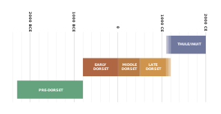
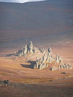
The history of Nunavut covers the period from the arrival of the Paleo-Eskimo thousands of years ago to present day. Prior to the colonization of the continent by Europeans, the lands encompassing present-day Nunavut were inhabited by several historical cultural groups, including the Pre-Dorset, the Dorsets, the Thue and their descendants, the Inuit.

Nunavut is the newest, largest, and northernmost territory of Canada. It was separated officially from the Northwest Territories on April 1, 1999, via the Nunavut Act and the Nunavut Land Claims Agreement Act, which provided this territory to the Inuit people for independent government. The boundaries had been drawn in 1993. The creation of Nunavut resulted in the first major change to Canada's political map since the province of Newfoundland was incorporated in 1949.

The Fish River is a waterway in the U.S. state of Alaska. The 47-mile-long (76 km) river rises in the Bendeleben Mountains and flows south to Golovnin Lagoon, before emptying into Golovnin Bay, Norton Sound, and the Bering Sea. The basin formed by the Fish River is known for its placer gold deposits, and in particular, the Niukluk River and its tributaries; production from this tributary valley is reported to be more than from any other place in the region. A galena mine existed 40 miles (64 km) from the sea, worked on occasion by a San Francisco corporation with a few hundred tons of ore taken to the city for smelting and refining for silver. Walter Curran Mendenhall found obscure fossils on Fish River at White Mountain.

Caribou Inuit, barren-ground caribou hunters, are bands of inland Inuit who lived west of Hudson Bay in Keewatin Region, Northwest Territories, now the Kivalliq Region of present-day Nunavut between 61° and 65° N and 90° and 102° W in Northern Canada. They were originally named "Caribou Eskimo" by the Danish Fifth Thule Expedition of 1921-4 led by Knud Rasmussen. Caribou Inuit are the southernmost subgroup of the Central Inuit.

Kangiqtugaapik formerly Clyde Inlet is a body of water in eastern Baffin Island, Qikiqtaaluk Region, Nunavut. Its mouth opens into the Davis Strait from the west.
The High Arctic relocation took place during the Cold War in the 1950s, when 92 Inuit were moved by the Government of Canada under Liberal Prime Minister Louis St. Laurent to the High Arctic.

The Lindstrom Peninsula is located on the southern coast of Ellesmere Island, a part of the Qikiqtaaluk Region of the Canadian territory of Nunavut. Across Baffin Bay to the south lies Devon Island. Harbour Fiord and Landslip Island are to the west, while the Grise Fiord is to the east. The highest peak on the peninsula is Mount Aqiatushuk 76°25′40″N083°15′00″W.

Inuit Nunangat is the homeland of the Inuit in Canada. This Arctic homeland consists of four northern Canadian regions called the Inuvialuit Settlement Region, the territory Nunavut (ᓄᓇᕗᑦ), Nunavik (ᓄᓇᕕᒃ) in northern Quebec and Nunatsiavut of Newfoundland and Labrador.
Niaqurnaaluk (Inuktitut syllabics: ᓂᐊᖁᕐᓈᓗᒃ formerly Cape Eglinton is a land point on eastern Baffin Island, in the Qikiqtaaluk Region, Nunavut, Canada. It was previously named by Sir John Ross in honour of the Earl of Eglinton.
Cape Aston is a large peninsula on eastern Baffin Island, Qikiqtaaluk Region, Nunavut, Canada. Located on Baffin Bay just south of Clyde Inlet, the closest settlement is Clyde River. The cape includes an ice-derived delta.
Asiagmiut were an Arctic coast Copper Inuit group in Kitikmeot Region, Nunavut, Canada. They were located near Ogden Bay east of the Coppermine River, between the Coppermine River and Tree rivers, west of Kent Peninsula, east of Kent Peninsula, and opposite Melbourne Island. Hudson (1989) mentions the Asiagmiut, a Caribou Inuit group of the Kazan River area, who were subsistence hunters.

Kangiqtualuk Uqquqti formerly Sam Ford Fiord is an isolated, elongated Arctic fjord on Baffin Island's northeastern coast in the Qikiqtaaluk Region of Nunavut, Canada. The Inuit settlement of Pond Inlet is 320 km (200 mi) to the northwest and Clyde River is 80 km (50 mi) to the east.
Arviqtujuq Kangiqtua formerly Eglinton Fiord is a fjord on Baffin Island's northeastern coast in the Qikiqtaaluk Region of Nunavut, Canada. The Inuit settlement of Pond Inlet is 355 km (221 mi) to the northwest and Clyde River is 55 km (34 mi) to the east.

The Remote Peninsula is a peninsula located on the eastern coast of Baffin Island. It is part of the Qikiqtaaluk Region of the Canadian territory of Nunavut. The Inuit settlement of Pond Inlet is 295 km (183 mi) to the northwest and Clyde River is 90 km (56 mi) to the southeast.

The UtkuhiksalingmiutUkukhalingmiut, Utkukhalingmiut —the people of the place where there is soapstone—is one of 48 groups of Inuit in what is now Nunavut, Canada. Their traditional land was around Chantrey Inlet (Tariunnuaq) area, near the estuary of the Back River in, what was then called, the Keewatin District of the Northwest Territories. The Utkuhiksalingmiut followed the traditional hunter-nomadic life moving from fishing the camp near the mouth of the Back River on Chantrey Inlet to their caribou hunting camp in the Garry Lake area, living in winter snow houses (igloos) and caribou skin tents in the summer. Oonark learned early how to prepare skins and sew caribou skin clothing. They subsisted mainly on trout, whitefish, and barren-ground caribou.
References
- ↑ Hodge, Frederick Webb (1912). Handbook of American Indians north of Mexico (Now in the public domain. ed.). Govt. printing office. pp. 88–. Retrieved 27 August 2011.CS1 maint: discouraged parameter (link)
- ↑ Wenzel, George W. (2008). "Inuit settlement in the Clyde area during "contact-exploration" times (ca. 1820-1895)" (PDF). Études/Inuit/Studies. 32 (2): 73–84. doi: 10.7202/038216ar .
- ↑ Heath, John D.; Arima, Eugene Y. (2004). Eastern Arctic kayaks: history, design, technique. University of Alaska Press. pp. 124–. ISBN 978-1-889963-26-6 . Retrieved 26 August 2011.CS1 maint: discouraged parameter (link)
- ↑ United States. Government Printing Office (1888). Congressional serial set (Now in the public domain. ed.). U.S. G.P.O. pp. 440–. Retrieved 26 August 2011.CS1 maint: discouraged parameter (link)