
The Eastern Province, also known as the Eastern Region, is the easternmost of the 13 provinces of Saudi Arabia. It is the largest province by area and the third most populous after the Riyadh Province and the Mecca Province. In 2017, the population was 4,900,325. Of these, 3,140,362 were Saudi citizens and 1,759,963 were foreign nationals The province accounts for 15.05% of the entire population of Saudi Arabia and is named for its geographical location relative to the rest of the kingdom.

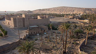
Jubail is a city in the Eastern province on the Arabian Gulf coast of Saudi Arabia, with a total population of 684,531 as of 2021. It is home to the largest industrial city in the world. It is also home to the Middle East's largest and world's fourth largest petrochemical company SABIC. It has the world's largest IWPP producing 2743.6 MW of electricity and 800,000 m3 of water daily. Jubail comprises the Old Town of Al Jubail, which was a small fishing village until 1975, and the Industrial Area. Jubail Industrial City is the largest civil engineering project in the world today.

Al Ahsa also known as Hajar is the largest governorate in Saudi Arabia's Eastern Province, named after the Al-Ahsa Oasis. The name Al-Ahsa is also given to the biggest city in the governorate, Hofuf. In Classical Arabic, 'Ahsa' means the sound of water underground. It has one of the largest oases in the world with world-renowned date palms and, according to one author, the oases of Al-Hasa and Al Ain are the most important in the Arabian Peninsula. The oasis is located about 60 mi (97 km) inland from the Persian Gulf. All urban areas are located in the traditional oasis of Al-Hasa. In addition to the oasis, the county also includes the giant Empty Quarter desert, making it the largest governorate in Saudi Arabia in terms of area. The Empty Quarter has the world's largest oil fields, and connects Saudi Arabia to Qatar, the UAE, and Oman. The Governorate's population is over 1,100,000. In the past, Al-Ahsa belonged to the historical region known as Bahrain, along with Qatif and the present-day Bahrain islands.

Zubarah, also referred to as Al Zubarah or Az Zubarah, is a ruined and ancient fort located on the north western coast of the Qatar peninsula in the Al Shamal municipality, about 105 km from the Qatari capital of Doha. It was founded by Shaikh Muhammed bin Khalifa, the founder father of Al Khalifa royal family of Bahrain, the main and principal Utub tribe in the first half of the eighteenth century. It was designated a UNESCO World Heritage Site in 2013.

Uqair, alternatively spelled as al-'Uqair, Uqayr, and Ogair, is an ancient seaport city in the Al-Ahsa Governorate of the Eastern Province of Saudi Arabia. It is the first seaport in the Persian Gulf and has been linked by some to the ancient city of Gerrha mentioned in Greek and Roman sources. The site was also the location of the conference at which the Uqair Protocol of 1922 was issued, which helped to establish the borders of modern Saudi Arabia.

Rustaq is a town and Wilayah (District) in Al Batinah Region of northern Oman. The wilayah is in the Western Hajar Mountains, in the south of the Batinah. Rustaq was once the capital of Oman, during the era of Imam Nasir bin Murshid al Ya'arubi. Rustaq Fort, built four centuries prior to the 7th century CE, is an imposing structure built on three levels, containing separate houses, an armoury, a mosque and four towers. The tallest tower stands over 18.5 m (61 ft) high, and has a diameter of 6 m (20 ft).
Ibri is a city and Wilāyat (Province) in the Ad Dhahirah Governorate, in northwest Oman.
Adam is a town in the region Ad Dakhiliyah, in northeastern Oman.

Samāʾil is a Wilayah (Province) located in Ad-Dakhiliyah Region of the Sultanate of Oman. It is surrounded by a range of towering mountains, and its well-known valley, Wadi Samail. It is approximately 50 kilometers away from the capital, Muscat. The population is around 40,000 people, spread across 55 villages and towns.

Eastern Arabia is a region stretched from Basra to Khasab along the Persian Gulf coast and included parts of modern-day Bahrain, Kuwait, Iraq, Eastern Saudi Arabia, United Arab Emirates, Qatar, Oman, and Yemen. The entire coastal strip of Eastern Arabia was known as "Bahrain" for a millennium.
Manah is a town in the region of Ad Dakhiliyah, in northeastern Oman. As of 2010 it had a population of 7,749.

Majdal Yaba was a Palestinian Arab village in the Ramle Subdistrict, located 18.5 kilometres (11.5 mi) northeast of Ramla and 4 kilometres (2.5 mi) east of Jaffa. A walled Jewish settlement name Migdal Aphek stood at the same site as early as the second century BCE, and it was later destroyed by the Romans during the First Jewish–Roman War in 67 CE. In the Crusader period, a fort named Mirabel was built at the site. During the Islamic period it became known as Majdal Yaba. For a short time under Ottoman rule, its name was changed from Majdal Yaba to Majdal Sadiq and then back again.
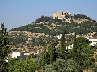
Ajloun Castle, medieval name Qalʻat ar-Rabad, is a 12th-century Muslim castle situated in northwestern Jordan. It is placed on a hilltop belonging to the Mount Ajloun district, also known as Jabal 'Auf after a Bedouin tribe which had captured the area in the 12th century. From its high ground the castle was guarding three wadis which descend towards the Jordan Valley. It was built by the Ayyubids in the 12th century and enlarged by the Mamluks in the 13th.

Dubai Museum is the main museum in Dubai, United Arab Emirates. It is located in the Al Fahidi Fort, built in 1787 and is the oldest existing building in Dubai.
Al Zubara Fort (Arabic: حصن الزبارة), also known as Fort Zubara(h), Zubara(h) Fort, Al Zubarah Fort, or Az Zubara(h) Fort, is a historic Qatari military fortress built under the oversight of Sheikh Abdullah bin Jassim Al Thani in 1938.
Qalaat al-Madiq is a town and medieval fortress in northwestern Syria, administratively part of the Hama Governorate, located northeast of Hama. It is situated in the al-Ghab plain, on the eastern bank of the Orontes River. Nearby localities include the district center al-Suqaylabiyah to the south, Bureij and Karnaz to the southeast, Kafr Nabudah to the east, al-Huwash to the north, Huwayjah al-Sallah and Shathah to the northwest and Al-Tuwayni and Ennab to the west. According to the Syria Central Bureau of Statistics (CBS), Qalaat al-Madiq had a population of 12,925 in the 2004 census. It is the administrative center and second largest locality in the Qalaat al-Madiq nahiyah ("subdistrict") which consisted of 40 localities with a collective population of 85,597 in 2004. The town's inhabitants are predominantly Sunni Muslims.
Qaryat al-Ulya is a city located in the north-east of the Eastern Province, Saudi Arabia, specifically in the historic aṣ-Ṣummān area, which consists of more than 30 villages; Qaryat al-Ulya is the capital of this region. The whole Summan area includes a population of more than 50,000 people, 80% of them Saudis, according to the 2011 census. They maintain an agricultural area with more than two thousand wheat farms, which ranks it first in Saudi Arabian wheat production.

Al-Buraimi is an oasis city and a wilayah (province) in northern Oman, on the border between Oman and the United Arab Emirates. It is the capital of the Al Buraimi Governorate. It is bordered by the wilayas Mahdha and Dhank. It is also bordered by the city of Al Ain in the United Arab Emirates. It is approximately 343 km away from the capital, Muscat, and has taken the motto of the Al Khandaq Fort.
Al-Dafi archaeological site is a site that may be found near the eastern city of Jubail, Saudi Arabia. The location was established around the second century BC. The location was found during the time.

