
Bayda, or Elbeida ( or ; Arabic: البيضاء al-Bayḍāʾ ), is a commercial and industrial city in eastern Libya. It is located in northern Cyrenaica. With a population of 250,000 people, Bayda is the 4th-largest city in Libya. It is the capital city of the Jabal al Akhdar district.
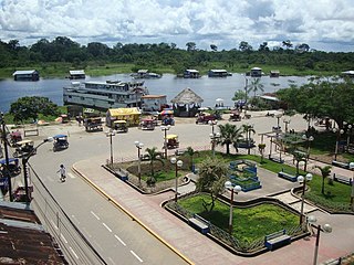
Caballococha is a town in the Loreto Region in northeastern Peru, located on the Amazon River and right across the river from Colombia.
Shuqrah, also Shaqrāʾ or Shuqrāʾ, is a coastal town in southern Yemen. It was the capital of the Fadhli Sultanate until the capital moved to Zinjibar in 1962, although the royal residence remained in Shuqrah.
General Lavalle is a city located in the east of the province of Buenos Aires, Argentina. It's the administrative center of the partido of General Lavalle, and the General Lavalle municipality. It has a population of 3,046 (2001 census [INDEC]. The city, partido, and municipality, are named after Juan Lavalle, who was a military and political figure in the early years of the Argentine state.

Bardia, also El Burdi or Bardiyah is a Mediterranean seaport in the Butnan District of eastern Libya, located near the border with Egypt. It is also occasionally called Bórdi Slemán.
Lal (La'l) sometimes called Lal wa Sarjangal is a town and the administrative center of Lal wa Sarjangal District, Ghor province in central Afghanistan.

Al Abraq International Airport or Al Bayda International Airport is an airport serving the eastern Libyan city of Bayda. The airport is 16 kilometres (9.9 mi) east of Bayda, 16 km west of the town of Al Abraq, and 12 kilometres (7.5 mi) south of Libya's Mediterranean coast. The airport is also known as El Beida International Airport or Airport International El Beida la Abraq.
Rashida (Rasceda) is a desert village in the Jalo oasis of the Al Wahat District in the Cyrenaica region in northeastern Libya. It is about 3.7 kilometres (2.3 mi) southwest of the town of Jalu. In 1951, the population was reported as about 600.

The Chiloango River is a river in western Central Africa. It forms the westernmost part of the border between the Democratic Republic of the Congo and the Republic of Congo, and then forms approximately half of the border between the DRC and Cabinda, Angola passing just south of the town of Necuto. The river then bisects Cabinda, making it the most important river in the province. It enters the Atlantic Ocean just north of the town of Cacongo.
Cacongo is a town, with a population of 15,000 (2014), in Cacongo municipality, Cabinda Province, in Angola. The former Lândana municipality is now known as Cacongo, and the town is sometimes still known as Lândana. It is located on Lândana Bay about a kilometer south of the mouth of the Chiloango River.
Karabiga (Karabuga) is a town (belde) in the Biga District, Çanakkale Province, Turkey. Its population is 2,962 (2021). It is located at the mouth of the Biga River, on a small east-facing bay, known as Karabiga Bay. Its ancient name was Priapus or Priapos.
Sidi Yahya El Gharb is a town in Sidi Slimane Province, Rabat-Salé-Kénitra, Morocco. At the 2004 census, its population was 31,705.
Jumayl is a town in central Nuqat al Khams District of western Libya. It is located about 10 kilometres (6 mi) southwest of Libya's Mediterranean Sea port in the city of Zuwarah. As of 2010, Jumayl had an estimated population of 102,000.
Firsilla (Farsillah) is a village in Derna District in northeastern Libya. The village located on the east side of the Akhdar Mountains. The village of Firsilla formed around a spring of the same name.
Qayqab is a town in the Derna District in northeastern Libya. The town is located on the northeast side of the Akhdar Mountains, south of Al Abraq and Al Abraq Airport and Faydiya lies to the southwest, connected by road.
Luigi di Savoia may refer to:
Oulad H'Cine is a small town and rural commune in Sidi Slimane Province, Rabat-Salé-Kénitra, Morocco. At the time of the 2004 census, the commune had a total population of 27,972 people living in 4389 households.
Al Hayshah is a coastal town in the Misrata District in the Tripolitanian region of northeastern Libya. It is located 19 kilometres (12 mi) from the Mediterranean Sea, on the Wadi Umm el Algian, 31 kilometres (19 mi) north-northeast of Al Qaddāḩīyah (Gheddahia), next to the Hayshah salt flats.

The Pajarito Mountains are a small mountain range in the Sierra Madre Occidental. They are located in the state of Sonora in northwestern Mexico.

The Battle of Bayda was the first conflict that broke out during the First Libyan Civil War between the brigades of Colonel Muammar Gaddafi and the Libyan rebels in the 4th-largest city in the country, the city of Bayda and its suburbs. The battle took place as a result of the demonstrations calling for the fall of the regime in Bayda, and after that the demonstrators clashed with the personnel of the internal security Agency in the city and the Talaa Khamis Brigade and the mercenaries and the Hussein Al-Jouifi Brigade stationed in Shahhat and Al Abraq International Airport in Bayda. The fighting continued one day in Bayda and the city was liberated, and then the Libyan revolutionaries headed to the outskirts of the city in Shahhat and Al-Abraq Airport. The revolutionaries were able to control the city and its suburbs, and thus Bayda was the first city to break out of Gaddafi's control and remained under the rebels' control throughout the revolution.
