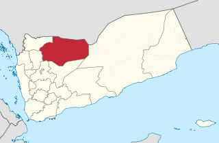
Al Mahwit is one of the governorates of Yemen.
Tawahi or is a city district in the city of Aden, located in the Aden Governorate in Yemen.

Az Zahir District is a district of the Al Bayda Governorate, Yemen. As of 2003, the district had a population of 25,704 inhabitants.
Al Ghayl District is a district of the Al Jawf Governorate, Yemen. As of 2003, the district had a population of 10,436 people.
Al Hazm District is a district of the Al Jawf Governorate, Yemen. As of 2003, the district had a population of 30,952 inhabitants. The capital lies at Al Hazm.
Al Humaydat District is a district of the Al Jawf Governorate, Yemen. As of 2003, the district had a population of 20,026 inhabitants.
Al Maslub District is a district of the Al Jawf Governorate, Yemen. As of 2003, the district had a population of 9,938 inhabitants.

Al Matammah District is a district of the Al Jawf Governorate, Yemen. As of 2003, the district had a population of 28,935 inhabitants.
Al Maton District is a district of the Al Jawf Governorate, Yemen. As of 2003, the district had a population of 28,411 inhabitants.
Bart Al Anan District is a district of the Al Jawf Governorate, Yemen. As of 2003, the district had a population of 59,463 inhabitants.
Kharab Al Marashi District is a district of the Al Jawf Governorate, Yemen. As of 2003, the district had a population of 63,532 inhabitants.
Man'ar District is a district of the Al Mahrah Governorate, Yemen. As of 2003, the district had a population of 5,388 inhabitants.
Ma'ain District is a district of the Amanat Al Asimah Governorate, Yemen. As of 2003, the district had a population of 265,269 inhabitants.
Al Manar District is a district of the Dhamar Governorate, Yemen. As of 2003, the district had a population of 49,390 inhabitants.
Al Madaribah Wa Al Arah District is the westernmost and southernmost of the 15 districts of the Lahij Governorate, Yemen. With an area of 1848.50 km², it is also the largest of all districts within the governorate. As of the census of population on 2004-12-16, the district had a population of 45,808 inhabitants.
Al Qabbaytah District is a district of the Lahij Governorate, Yemen. As of 2003, the district had a population of 94,516 inhabitants.
Al Hashwah District is a district of the Sa'dah Governorate, Yemen. As of 2003, the district had a population of 14,274 people.
Al Husn District is a district of the Sana'a Governorate, Yemen. As of 2003, the district had a population of 30,124 inhabitants.
Sanhan District is a district of the Sana'a Governorate, Yemen. Its seat is Sanhan. As of 2003, the district had a population of 400,399 inhabitants.