
Yemen, officially the Republic of Yemen, is a country in West Asia. Located in southern Arabia, it borders Saudi Arabia to the north, Oman to the northeast, the Red Sea to the west, and the Indian Ocean to the south, sharing maritime borders with Eritrea, Djibouti and Somalia across the Horn of Africa. Covering roughly 455,000 square kilometres, with a coastline of approximately 2,000 kilometres, Yemen is the second largest country on the Arabian Peninsula. Sanaa is its constitutional capital and largest city. Yemen's estimated population is 34.7 million, mostly Arab Muslims. It is a member of the Arab League, the United Nations, the Non-Aligned Movement and the Organisation of Islamic Cooperation.
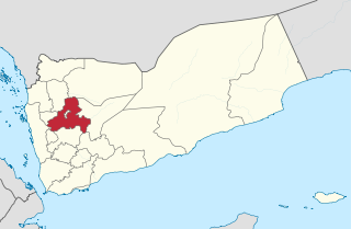
Sanaa, also spelled San'a' or Sana, is a governorate of Yemen. Its capital is Sanaa, which is also the national capital. However, the city of Sanaa is not part of the governorate but instead forms the separate governorate of Amanat Al-Asemah. The Governorate covers an area of 13,850 km2 (5,350 sq mi). As of 2004, the population was 2,918,379 inhabitants. Within this place is Jabal An-Nabi Shu'ayb or Jabal Hadhur, the highest mountain in the nation and the Arabian Peninsula.

Anwar Nasser Abdulla al-Awlaki was an American-Yemeni lecturer and jihadist who was killed in 2011 in Yemen by a U.S. government drone strike ordered by President Barack Obama. Al-Awlaki became the first U.S. citizen to be targeted and killed by a drone strike from the U.S. government. U.S. government officials have claimed that al-Awlaki was a key organizer for the Islamist militant group al-Qaeda.
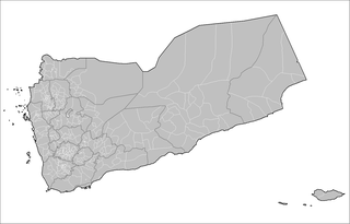
The administrative division of Yemen consists of two main divisions. There are 22 governorates, including the capital Sana'a and Socotra Archipelago. The 22 governorates are then divided into 333 districts, subdivided into 2,210 sub-districts, and then into 38,284 villages.

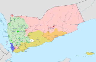
The Houthi insurgency, also known as the Houthi rebellion, the Sa'dah Wars, or the Sa'dah conflict, was a military rebellion pitting Zaidi Shia Houthis against the Yemeni military that began in Northern Yemen and has since escalated into a full-scale civil war. The conflict was sparked in 2004 by the government's attempt to arrest Hussein Badreddin al-Houthi, a Zaidi religious leader of the Houthis and a former parliamentarian on whose head the government had placed a $55,000 bounty.
Judeo-Yemeni Arabic is a variety of Arabic spoken by Jews living or formerly living in Yemen. The language is quite different from mainstream Yemeni Arabic, and is written in the Hebrew alphabet. The cities of Sana'a, Aden, al-Bayda, and Habban District and the villages in their districts each have their own dialect.

Sanaa, officially the Sanaa Municipality, is the capital and largest city of Yemen. The city is the capital of the Sanaa Governorate, but is not part of the governorate, as it forms a separate administrative unit. According to the Yemeni constitution, Sanaa is the capital of the country, although the seat of the Yemeni government moved to Aden, the former capital of Democratic Yemen, in the aftermath of the Houthi occupation. Aden was declared the temporary capital by then-president Abdrabbuh Mansur Hadi in March 2015.
The Al-Qaeda insurgency in Yemen is an ongoing armed conflict between the Yemeni government, the United States and their allies, and al-Qaeda-affiliated groups in Yemen. It is a part of the Global War on Terror.
Sayun District is a district of the Hadhramaut Governorate, Yemen. As of 2003, the district had a population of 102,409 inhabitants.
Shibam District is a district of the Hadhramaut Governorate, Yemen. Its capital is the town of Shibam, famous for its mudbrick-made tower houses and known as the "Manhattan of the desert". During the Yemen Civil War, the city suffered some damage.
Al Dhihar District is a district of the Ibb Governorate, Yemen. As of 2003, the district had a population of 154,399 inhabitants.
Al Makhadir District is a district of Ibb Governorate, Yemen. As of 2003, the district had a population of 113,892 inhabitants.
Al Qafr District is a district of the Ibb Governorate, Yemen. As of 2003, the district had a population of 103,272 inhabitants.
An Nadirah District is a district of the Ibb Governorate, Yemen. As of 2003, the district had a population of 73,755 inhabitants.
As Sabrah District is a district of the Ibb Governorate, Yemen. As of 2003, the district had a population of 69,872 inhabitants.
As Sayyani District is a district of the Ibb Governorate, Yemen. As of 2003, the district had a population of 110,515 inhabitants.
Ash Sha'ir District is a district of the Ibb Governorate, Yemen. As of 2003, the district had a population of 39,805 inhabitants.
Ba'dan District is a district of the Ibb Governorate, Yemen. As of 2003, the district had a population of 116,045 inhabitants.
Dhi As Sufal District is a district of the Ibb Governorate, Yemen. As of 2003, the district had a population of 163,019 inhabitants.

Bani Matar District is a district of the Sanaa Governorate, Yemen. As of 2003, the district had a population of 100,012 inhabitants.

