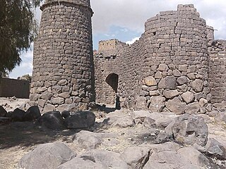
Dhale is one of the Yemeni governorates that was created after the unification of Yemen. The population of the province accounts for 2% of the total population of the republic. The governorate is divided into 9 districts. The city of Dhale is the administrative centre of the province. Dali is one of the governorates that is known for agriculture, and most of the population works in that industry. The most important agricultural crop is coffee. The province also contains mineral resources, most importantly talc, which is used in the manufacture of paper, paint, cosmetics and pesticides. This governorate is also home to the Damt hot-springs (Ḥamam-Damt), a popular tourist attraction. One of the ancient cities in the region is Juban, a city famous for its castle and the historic Mansuria school, built by the Tahrids. The climate in Dhale governorate is mostly temperate throughout the year.

Lahij is a governorate of Yemen.

Sana'a University was established in 1970 as the first and the primary university in the Yemen Arab Republic, now the Republic of Yemen. It is located in Sanaa, the capital of Yemen, and is currently organized with 17 faculties. Previously the university was located at 15°20′53.16″N44°11′26.83″E. The university includes several accommodation buildings for staff and students and is partnered with the Kuwait University Hospital for medical students.
Iyal Surayh District is a district of the 'Amran Governorate, Yemen. As of 2003, the district had a population of 54,015 inhabitants.
At Tahrir District is a district of the Amanat Al Asimah Governorate, Yemen. As of 2003, the district had a population of 66,898 inhabitants.
Assafi'yah District is a district of the Amanat Al Asimah Governorate, Yemen. As of 2003, the district had a population of 109,109 inhabitants.
Bani Al Harith District is a district of the Amanat Al Asimah Governorate, Yemen founded by a sub-clan of Banu Harith. As of 2003, the district had a population of 184,509 inhabitants.
Al-Mawasit District is a district of the Taiz Governorate, Yemen. As of 2003, the district had a population of 115,857 inhabitants.
Al Misrakh District is a district of the Taiz Governorate, Yemen. As of 2003, the district had a population of 112,653 inhabitants.
At Ta'iziyah District is a district of the Taiz Governorate, Yemen. As of 2003, the district had a population of 109,814 inhabitants.
Sabir Al Mawadim District is a district of the Taiz Governorate, Yemen. As of 2003, the district had a population of 100,254 inhabitants.

Al Qabbaytah District is a district of the Lahij Governorate, Yemen. As of 2003, the district had a population of 94,516 inhabitants.
Harib Al Qaramish District is a district of the Ma'rib Governorate, Yemen. As of 2003, the district had a population of 8,573 inhabitants.

Arhab District is a district of the Sana'a Governorate, Yemen. As of 2003, the district had a population of 90,038 inhabitants.
Bani Dhabyan District is a district of the Sana'a Governorate, Yemen. As of 2003, the district had a population of 16,262 inhabitants. As of 2023, it is one of the only districts controlled by tribal forces.
Bani Hushaysh District is a district in Sana'a Governorate, Yemen. As of 2003, the district had a population of 73,957 inhabitants. It's also famous for grape plantations.
Bilad Ar Rus District is a district of the Sana'a Governorate, Yemen. As of 2003, the district had a population of 31,259 inhabitants.

Hamdan District is a district of the Sana'a Governorate, Yemen. As of 2003, the district had a population of 85,370 inhabitants. It is named after the ancient Yemeni tribe of Hamdan.
Sanhan and Bani Bahlul District is a district of the Sana'a Governorate, Yemen. Its seat is Sanhan. As of 2003, the district had a population of 400,399 inhabitants. The former President of Yemen Ali Abdullah Saleh comes from Beit al-Ahmar, which lies in Sanhan District.
Habab Al Hantash is a sub-district located in Khawlan District, Sana'a Governorate, Yemen. Habab Al Hantash had a population of 2526 according to the 2004 census.


