
Bekal Fort was built by Shivappa Nayaka of Keladi in 1650 AD, at Bekal. It is the largest fort in Kerala, spreading over 40 acres (160,000 m2).
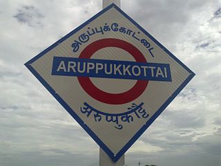
Aruppukottai is a town and a municipality in Virudhunagar district in the state of Tamil Nadu, India. Aruppukottai's classical name is "Sengattu Aravakotai". Aruppukottai is about 50 km from Madurai. It is in the middle of Madurai-Tuticorin National Highways NH-45B. The small villages and towns surrounding Aruppukottai are famous for production of jasmine. Aruppukottai is always famous for producing yarn. Sri Ramana Maharishi was born in Tiruchuli near Aruppukottai town. Aruppukottai was part of king Sethupathi of Ramnad. King Sethupathi has Zamin Palace in Palyampatti. Aruppukottai is well known for its high quality educational institutions. As of 2011, the town had a population of 97,722. After Madurai it is the only nearby city to have well built and maintained theaters. The town also hosts two famous temples – Arulmigu Amuthalingeshwarar Temple and Arulmigu Meenakshi Chokkanatha Swamy Temple on Thiruchuzhi Road.

Virudhunagar is a town and the administrative headquarters of the Virudhunagar district in the Indian state of Tamil Nadu. It is located 506 km (314 mi) southwest of the state capital Chennai and 53 km (33 mi) south of Madurai. Virudhunagar emerged as an important trade centre during the British rule. The town is the birthplace of freedom fighter K. Kamaraj, former Chief minister of Tamil Nadu, and Bharat Ratna recipient. Located to the east of Kowsika River, Virudhunagar has an average elevation of 102 m (335 ft) above sea level and is largely flat with no major geological formations. The town has a humid climate and receives 780 mm (31 in) rainfall annually.Has been ruled at various times by Later Pandyas, Vijayanagar Empire, Madurai Nayaks, Chanda Sahib, Carnatic kingdom and the British. It was formerly known as Virudhupatti.

Chandragiri is a town in Chittoor district of the Indian state of Andhra Pradesh. It is the mandal headquarters of Chandragiri mandal in Tirupati revenue division. It also falls in the jurisdictional limit of Tirupati Urban Development Authority.

Shivappa Nayaka (r.1645–1660), popularly known as Keladi Shivappa Nayaka, was an Indian king and ruler of the Keladi Nayaka Kingdom. The Keladi Nayakas were successors of the Vijayanagara Empire in the coastal and Malnad (hill) districts of Karnataka, India, in the late 16th century. At their peak, the Nayakas built a niche kingdom comprising the coastal, hill and some interior districts (Bayaluseeme) of modern Karnataka, before succumbing to the Kingdom of Mysore in 1763, which at that time was ruled by Hyder Ali. He was known as Sistina Shivappa Nayaka because he introduced a tax system called Sist.

Chandragiri Fort is a fort built in the 17th century, situated in Kasaragod District of Kerala, South India. This large squarish fort is 150 feet (46 m) above sea level and occupies an area of about seven acres by the side of the river Payaswini. The fort is now in ruins.

Chitradurga is a city and the headquarters of Chitradurga district which is located on the valley of the Vedavati river in the central part of the Indian state of Karnataka. Chitradurga is a place with historical significance which is located to the North West about 200 km from the state capital Bengaluru. Chitradurga is a Major tourist hub in Karnataka. The City is famous for its Fort It is also locally known as "Kallina Kote" or Stone Fortress, which is also formed of two Kannada words ‘Kallina’: "Stone" and Kote: "Fort". Other names used in Kannada are ‘Ukkina Kote": "Steel Fort" and ‘Yelusuttina Kote’: "Seven Circles Fort". Chitradurga is very distinctive with its curious myths, human dwellings dating back to Stone age, enriched with the sites of ancient, historical, cultural and religious significance has been a place with a civilization of thousands of years and an amalgamation of antiquity and modernisation.
Nayaka dynasties emerged during the Kakatiyas and Vijayanagara Empire. The Nayakas were originally military governors under the Vijayanagara Empire. After the battle of Talikota, several of them declared themselves independent. The Nayaka kingdoms included the following:
Virudhunagar District is a district of Tamil Nadu state in south India. Virudhunagar is the district headquarters and the largest town in Virudhunagar district. Virudhunagar district was formed by the separation of Old Ramanathapuram District in 1987 into Ramanathapuram District, Sivagangai District and the west part as Virudhunagar District. Virudhunagar District was formerly called Karmavirer Kamarajar District. As of 2011, Virudhunagar district had a population of 1,942,288 with a sex-ratio of 1,007 females for every 1,000 males.

Mallankinaru is a panchayat town in Virudhunagar district in the Indian state of Tamil Nadu.
Srivilliputhur, officially known as Thiruvilliputhur is a town and a Municipality in Virudhunagar district in the Indian state of Tamil Nadu. The name is pronounced as 'Sreevilliputhoor'. As of 2011, the town had a population of 75,396. The most important landmark of Srivilliputhur is 11-tiered tower structure dedicated to the Vatapatrasayee(Vishnu), the presiding deity of Srivilliputhur Divya Desam. The tower of this temple rises 192 feet high and is the official symbol of the Government of Tamil Nadu. It is said to have been built by Periyalvar, in the year 788 AD believed to be the adopted father of the Temple Deity, with a purse of gold that he won in debates held in the palace of Pandya King Vallabhadeva. Srivilliputhur is well known for its ancient heritage and devotional contributions.

Nayakas of Chitradurga ruled parts of eastern Karnataka during the post-Vijayanagara period. During the rule of Hoysala Empire and Vijayanagara Empire, they served as a feudatory chiefdom. Later after the fall of the Vijayanagara empire, they ruled at times as an independent Chiefdom and at other times as a vassal of the Mysore Kingdom, Mughal Empire and Maratha Empire. Finally their territories merged into the province of Mysore under the British.
Nayakas of Keladi, also known as Nayakas of Bednore and Ikkeri Nayakas (1499–1763), were an Indian dynasty based from Keladi in Shimoga district, Karnataka, India. They were an important ruling dynasty in post-medieval Karnataka. They initially ruled as a vassal of the famous Vijayanagar Empire. After the fall of the empire in 1565, they gained independence and ruled significant parts of Malnad region of the Western Ghats in present-day Karnataka, most areas in the coastal regions of Karnataka, and parts of northern Kerala, Malabar and the central plains along the Tungabhadra river. In 1763 AD, with their defeat to Hyder Ali, they were absorbed into the Kingdom of Mysore. They played an important part in the history of Karnataka, during a time of confusion and fragmentation that generally prevailed in South India after the fall of the Vijayanagar Empire. The Keladi rulers were Nayakas (Beda's) but they were tolerant towards followers of other faiths. The Haleri Kingdom that ruled over Coorg between 1600 A.D and 1834 A.D. was founded by a member of the Keladi family.
Sattur is an assembly constituency located in Virudhunagar district in Tamil Nadu. It falls under Virudhunagar Lok Sabha Constituency.
Kollamkondan was a territory (Zamin) in the former Tirunelveli province of Madurai Nayak Dynasty ruled by Polygar. Post Independence of India it split into as 2 villages Ayan Kollan Kondan and Zamin Kollan Kondan and come under Virudhunagar District in the southern Indian State of Tamil Nadu in India.
Narikudi block is a revenue block in the Virudhunagar district of Tamil Nadu, India. It has a total of 44 panchayat villages. It is situated about 32 km from Aruppukkottai. The residential Areas are located in 3 places,viz., Hospital Area, Union Office Area and the Bus Stand Area. There is no remarkable business establishments here and for every thing the people will have to move to Aruppukkottai or Thiruppuvanam. The block has 3 revenue Firkas namely Narikudi, A.Mukkulam and Veeracholan. It comes under Thiruchuli Taluk. Narikudi has one Nationalized Indian Overseas Bank and one Co-operative Bank. Though there is a Railway Station, trains are running in this area between virudhunagar to karaikudi passenger train. The major cultivated crops are Paddy and Groundnut and these crops are mostly cultivated in Dry lands with the help of North East Monsoon.
The Manamadurai–Virudhunagar line is a railway line connecting Virudhunagar and Manamadurai towns in Tamil Nadu.
Akkanapuram is a village located in Watrap block, Srivilliputhur taluk, Virudhunagar district, Tamil Nadu State, India. The village is identified by two names: Akkanapuram Villaku and Akkanapuram itself. The village naming difference arose only because of the bus stop junction, because most of the buses do not transport passengers into the village, but just drop them at the 3-way junction Akkanapuram Villaku. The west side road of the village reaches to the town Watrap and the east side road of the village reaches to Alagapuri: at that junction it crosses at and again continues till Virudhunagar. The north side road of the village goes to Periayur. The closest city is Madurai, and nearest towns are Watrap, Srivilliputhur, Pallapatti, Virudhunagar and Sivakasi. Also, the closest airport is Madurai Airport which is 50 kilometres away. Most of the people that live in the village are Paraiyar and are farmers.
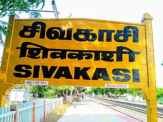
Sivakasi railway station is a railway station in the town of Sivakasi, Virudhunagar district in Tamil Nadu.
