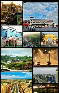
Tirunelveli also known as Nellai and historically as Tinnevelly, is a major city in the Indian state of Tamil Nadu. It is the administrative headquarters of the Tirunelveli District. It is the sixth-largest municipal corporation in the state after Chennai, Coimbatore, Madurai, Trichy and Salem. Tirunelveli is located 700 km (430 mi) southwest of the state capital Chennai, 58 km (36 mi) away from Thoothukudi and 73 km (45 mi) from Kanyakumari. The downtown is located on the west bank of the Thamirabarani River; its twin Palayamkottai is on the east bank. Palayamkottai is called as the Oxford of the south India. It is a hub of many schools, colleges and many important government offices.

Tirunelveli district is one of the 38 districts of Tamil Nadu state in India. It is the largest district in terms of area with Tirunelveli as its headquarters. The district was formed on 1 September 1790 by the British East India Company, and comprised the present Tirunelveli and Thoothukudi, Tenkasi and parts of Virudhunagar and Ramanathapuram district. As of 2011, the undivided district had a population of 3,077,233.

Alwarkurichi is a panchayat town in Tenkasi district in the state of Tamil Nadu, India.

Kalakkad is a Panchayat town in Tirunelveli district in the Indian state of Tamil Nadu. Currently, the Chairman of the Town Panchayat is PC Rajan, who hails from the nearby village called Manjuvilai. The town is centered on the Sathya Vageeswarar Temple.
Moolakaraipatti is a Panchayat town in Tirunelveli district in the Indian state of Tamil Nadu. It's an ancient town from the days of Pandyas. Now a Days Class Municipality. The old temple relics in that area speaks for itself. The Muslim and Christian settlement here is also from old days. The main communities here are Reddyiar, Konar, Nadars, Sambavars, Parayars, Thevar and Muslims along with other backward communities. People are very hardworking. The Konthankulam Bird Sanctuary is 4 km from here. A British English School, The Reach School. A Higher Secondary School and a Polytechnic adorns this township. A petrol pump is a km away. A good hospital, TNEB distribution station, a solar power station, Police Station and large number of shops constituting a bazaar lies in the main centre. Agriculture is the main income. A good cinema hall lies closed because of the general public non interest in such entertainments. The richness of the soil here produce the best rice, dal, pies, tapioca, plantains, sweet potato, all vegetables, which are sold at Tirunelveli and Valliyoor Market. Cattle rearing and Milk produce are also a business here.

Seithur' is a selection grade panchayat town in Rajapalayam taluk, Virudhunagar district in the Indian state of Tamil Nadu. Located in the Rajapalayam to Tenkasi NH208 Highway. Nature around western ghats due to greenish. Here there are many attractions near Seithur. Only 65 km to Courtallam, and only 5 km to Sasthakovil river.
Panchalankurichi is a small but historic village, 3 km from Ottapidaram and 21 km from Thoothukudi in Thoothukudi district, Tamil Nadu, India. Panchalankurichi was once a Palayam and is best known as the birthplace of Veerapandiya Kattabomman, an 18th-century Palayakarrar ('Polygar'), who opposed the British East India Company governance in the area and its revenue-raising methods.

Polygar was the feudal title for a class of territorial administrative and military governors appointed by the Nayaka rulers of South India during the 16th–18th centuries.
Panpoli is a village situated near Sengottai Taluk in Tenkasi district, Tamil Nadu, India.
The estate of Sivaganga, as per British records also known as Kingdom of the Lesser Marava, was a permanently settled zamindari estate in the Ramnad sub-division of Madura district, Madras Presidency, British India. Along the estate of Ramnad, it formed one of the two zamindari estates of Ramnad subdivision.

The Pothigai Superfast Express is an overnight Superfast train service operated between Chennai Egmore and Sengottai via Villupuram, Trichy, Madurai and Rajapalayam on the Southern Railway zone of the Indian Railways.
Thalaivankottai is traditionally recognized as one of the 72 Palaiyams of Madurai. This Maravar Palaiyam was located in the Sivagiri Taluk, at the foot of the Western Ghats, in the Tirunelveli province of the Nayak Kingdom of Madurai.
The Madras Presidency was a province of British India comprising most of the present day Tamil Nadu and Andhra Pradesh along with a few districts and taluks of Karnataka, Kerala and Orissa. A few princely states, notably Ramnad and Pudukkottai also merged into the Presidency at some or the other time. The Presidency lasted till 1950, when it became the Madras State after India became a republic. In 1953 Telugu-speaking regions of the state split to form Andhra State. Subsequently, in 1959, Kannada- and Malayalam-speaking areas were merged with Mysore and Travancore.
Kollamkondan was a territory (Zamin) in the former Tirunelveli province of Madurai Nayak Dynasty ruled by Polygar. Post Independence of India it split into as 2 villages Ayan Kollan Kondan and Zamin Kollan Kondan and come under Virudhunagar District in the southern Indian State of Tamil Nadu in India.
Sethur in the Srivilliputtur taluk, at the foot of the Western Ghats, northwest Tirunelveli, is traditionally recognized as one of the 72 palayams of Madura. Sethur today comes under Virudhunagar District of Tamil Nadu.
Nerkattumseval is traditionally recognized as one of the 72 palaiyams of Madura, already in existence in the days of Nagama Nayaka and his son Visvanatha Nayaka. It falls under the Sankarankovil taluk in Tenkasi District of Tamil Nadu.
Singampatti is traditionally recognized as one of the 72 palaiyams of Tamil Nadu, India. This palaiyam headed 24 of 72 palaiyams was located in the Ambasamudram taluk, two miles from the spurs of the Western Ghats, in Tirunelveli district.
Chokkampatti is traditionally recognized as one of the 72 palaiyams of Madura. This Palayam is also referred to in the early records as Vadagarai or Vadhagerri.
Uthumalai, also known as Uttumalai, is a village in the Indian state of Tamil Nadu. It lies in Veerakeralampudur taluk, which itself is in Tenkasi district.
