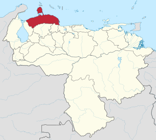
Falcón State is one of the 23 states of Venezuela. The state capital is Coro.

Lara State is one of the 23 states of Venezuela. Lara is located in the Central-Western Region, Venezuela. The state capital is Barquisimeto.
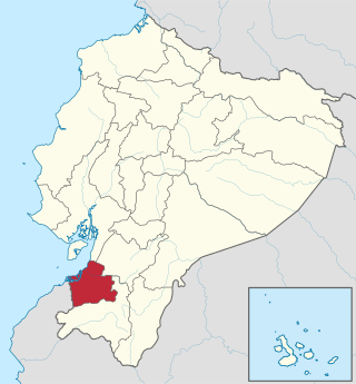
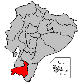
El Oro is the southernmost of Ecuador's coastal provinces. It was named for its historically important gold production. Today it is one of the world's major exporters of bananas. The capital is Machala.
Loja Province is one of 24 provinces in Ecuador and shares its southern border on the west with El Oro Province, on the north with El Azuay, and on the east with Zamora-Chinchipe. Founded on its present site in 1548 by Captain Alonso de Mercadillo (Spanish), the site had been previously moved and rebuilt from La Toma due to earthquakes. It also is named as "Cuxibamba Valley", from the Quichua language, which means the "Smiley Valley".

Zamora Chinchipe, Province of Zamora Chinchipe is a province of the Republic of Ecuador, located at the southeastern end of the Amazon Basin, which shares borders with the Ecuadorian provinces of Azuay and Morona Santiago to the north, Loja and Azuay to the west, and with Peru to the east and south. The province comprises an area of approximately 10,559 km² and is covered with a uniquely mountainous topography which markedly distinguishes it from the surrounding Amazonian provinces. Zamora-Chinchipe is characterized and largely identified by its mining industry; indigenous ethnic groups with a rich archaeological legacy; its biodiversity; and its niche and tourist attractions, which include a number of waterfalls well-noted for their beauty. The province takes its name from the bureaucratic fusion of the Zamora and Chinchipe cantons. The provincial capital is the city of Zamora.
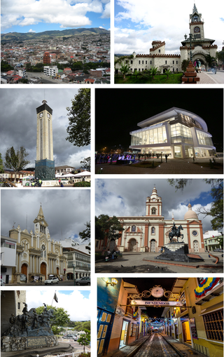
Loja, formerly Loxa and fully City of the Immaculate Conception of Loja, is the capital of Ecuador's Loja Province. It is located in the Cuxibamba valley in the south of the country, sharing borders with the provinces of Zamora-Chinchipe and other cantons of the province of Loja. Loja holds a rich tradition in the arts, and for this reason is known as the Music and Cultural Capital of Ecuador. The city is home to two major universities.

Zaruma, officially Villa Real de San Antonio del Cerro de Oro de Zaruma is a town in the south of Ecuador, El Oro Province. It is located in the south-east of this province, at an altitude of 1200 metres above sea level, on an inter-Andes route where the Vizcaya mountain range branches off from the Chilla mountain range. It is the seat of Zaruma Canton, one of the oldest cantons in the province.

Puyango is a canton of the Province of Loja, Ecuador. It is located in the west of the province, and borders the cantons of Paltas, Celica, Pindal, and Zapotillo.
Celica is a canton in Loja Province, Ecuador. Its seat is Celica. The canton is located in the west of the province and is bordered by the cantons of Puyango and Paltas in the north, Sozoranga in the east, Macará in the south, and Pindal and Zapotillo in the west. It covers 521.9 km2 at an altitude of 2,500 m.
El Carrizal is a municipality located in the department of Chalatenango in the North of El Salvador.

San Felipe Jalapa de Díaz is a town, and the surrounding municipality of the same name, in the Mexican state of Oaxaca. It is some 50 km west of Tuxtepec, and is part of the Tuxtepec District of the Papaloapan Region.

La Fortuna is a district of the San Carlos canton, in the Alajuela province of Costa Rica.
Gonzanamá is a small town and also part of one of the 16 cantons (Gonzanamá) in Loja Province, Ecuador.

Pedro Carbo Canton is a land-locked coastal canton located in Guayas Province in Ecuador, near Manabí Province. Its capital is the town of Pedro Carbo. It is located at the 63 kilometer marker on the road from Guayaquil to Manabí. It is the seat of Pedro Carbo Cantón, founded in 1984. As of the census of 2001, there are 36,711 people residing within canton limits. A new census was conducted in 2010 but results are yet unknown. The city is named after Pedro Carbo Noboa, a 19th-century politician, diplomat and writer from Guayaquil.
Zapotillo Canton is a canton of Ecuador, located in the Loja Province. Its capital is the town of Zapotillo. Its population at the 2001 census was 10,940.

Azurduy Municipality is the first municipal section of Azurduy Province in the Chuquisaca Department of Bolivia. Its seat is Villa Azurduy. In 2012 the population was 10,594 persons. The municipality is very poor; in 2010 93% were below the poverty line, and 75% were in extreme poverty. In 2001 there were seven automobiles in the municipality.

El Airo is a village located in the southern part of Ecuador's Loja province known for growing some of the best coffee in Ecuador. It is in the northwestern part of the Espindola canton about 25 km from Amaluza, the canton's capital.

The San Carlos River is a river in the Alajuela Province of Costa Rica that drains into the San Juan River and thus into the Caribbean Sea. Its basin covers an area of about 3,100 km2. The river has a length of 142 km of which about 60 km allow navigation. The river originates from the confluence of the Jabillos River and Peje River both originating on the eastern side of the Cordillera de Tilarán and traverses the San Carlos Canton. It meets the San Juan River close to Boca San Carlos.

Ecuador is a country with vast natural and cultural wealth. The diversity of its four regions has resulted in hundreds of thousands of species of flora and fauna. It has about 1640 species of birds. The species of butterflies line the 4,500, the 345 reptiles, 358 amphibians and 258 mammals, among others. Ecuador is considered one of the 17 countries where the greatest biodiversity of the planet is concentrated. Most of its flora and fauna live in 26 areas protected by the State. It also offers historical attractions such as Quito, food and a variety of cultures and traditions.

