
Albany is a city on the east shore of San Francisco Bay in northwestern Alameda County, California. The population was 20,271 at the 2020 census.

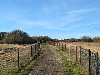
Point Pinole Regional Shoreline is a regional park on the shores of the San Pablo Bay, California, in the United States. It is approximately 2,315 acres (9.37 km2) in area, and is operated by the East Bay Regional Park District. It includes the Dotson Family Marsh and the Point Pinole Lagoon and hosts the North Richmond Shoreline Festival.

Crissy Field is a public recreation area on the northern shore of the San Francisco Peninsula in California, United States, located just east of the Golden Gate Bridge. It includes restored tidal marsh and beaches.

Schoolhouse Creek is a creek which flows through the city of Berkeley, California in the San Francisco Bay Area.

The Oakland Estuary is the strait in the San Francisco Bay Area, California, separating the cities of Oakland and Alameda and the Alameda Island from the East Bay mainland. On its western end, it connects to San Francisco Bay proper, while its eastern end connects to San Leandro Bay.
McLaughlin Eastshore State Park is a state park and wildlife refuge along the San Francisco Bay shoreline of the East Bay between the cities of Richmond, Albany, Berkeley, Emeryville, and Oakland. It encompasses remnant natural wetlands, restored wetlands, as well as landfill west of the Eastshore Freeway. Its shoreline is 8.5 miles (13.7 km) long, and its total area is 1,854 acres (750 ha), which includes both tidelands and uplands. Originally named just Eastshore State Park, it was renamed in October 2012 to honor the late Save the Bay founder Sylvia McLaughlin, who, along with the late Dwight Steele of Citizens for Eastshore Park, drove the establishment of the park. Prior to 2013, it was jointly managed by the California State Parks and East Bay Regional Park District (EBRPD). The state agency and EBRPD executed a 30-year agreement for EBRPD to manage the park.

Miller/Knox Regional Shoreline is a 295-acre (1.19 km2) bayside park near the Brickyard Cove neighborhood of the Point Richmond District in Richmond, California.

Point Isabel Regional Shoreline in Richmond, California, is operated by East Bay Regional Park District, and is a multi-use park for joggers, windsurfers, kayakers, photographers, picnickers, and people walking dogs. It has access for pedestrians and via public transit, private vehicles, and bikes. It also features a concession offering food for people and grooming for pets. A longtime community organization and nonprofit, Point Isabel Dog Owners and Friends (PIDO), is active in the maintenance and improvement of the park.
César Chávez Park is a 90 acres (36 ha) city park of Berkeley, California named after César Chávez. It can be found on the peninsula on the north side of the Berkeley Marina in the San Francisco Bay and is adjacent to Eastshore State Park.

Middle Harbor Shoreline Park (MHSP) is located on San Francisco Bay and the Port of Oakland entrance channel, west of downtown Oakland, California. It is owned and operated by the Port of Oakland. The park entrance is at the intersection of 7th Street and Middle Harbor Road. It is open seven days a week from 8 a.m. to dusk.

Brickyard Cove is an upscale waterfront neighborhood in Richmond, California.

The Damon Marsh is a tidal wetland at the northern edge of San Leandro Bay in Oakland, California, USA. There is a paved 0.84-mile (1.35 km) long shoreline trail along the waterfront to allow visual access to the San Leandro Bay and through the marsh itself. One end of this trailhead lies at Damon Slough. Access to the marsh is via the Hegenberger Road exit of Interstate 880. A 1989 biological study of the Damon Marsh found that this habitat supports the California clapper rail, a federally and state-listed endangered avian species.

Cull Canyon Regional Recreation Area (CCRRA) is a regional park located in Castro Valley, Alameda County, California. It is part of the East Bay Regional Park District (EBRPD) system.
Huckleberry Botanic Regional Preserve is a 241 acres (0.98 km2) regional park and nature reserve in the Oakland Hills, in the eastern East Bay region of the San Francisco Bay Area of California. It is within Alameda and Contra Costa Counties. It is a park within the East Bay Regional Parks District system. The Preserve is named after the California Huckleberry which grows abundantly within its habitat.
Fleming Point is a rocky promontory in the U.S. state of California. The rocky promontory is part of a band of rock, that geologists call the Novato Terrane. Which has been formed through titanic clashes of plates that have pulled the rock upwards. This area is the only original existing shoreline in the East Bay Region today. It is situated in Albany, on the eastern shore of San Francisco Bay. Albany Bulb is an extension of the point, having been formed in the 1960s from construction debris.

Point Molate Naval Fuel Depot is a decommissioned United States Navy fueling station on the western shore of Richmond, California on San Francisco Bay. It has undergone years of litigation and debate as to its redevelopment with proposals ranging from a billion dollar casino project, parkland, housing, and other mixed uses.
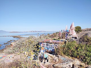
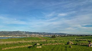
The Albany Bulb is a former landfill largely owned by the City of Albany, in California. The Bulb is the west end of a landfill peninsula jutting west from the east shore of San Francisco Bay. The term "Bulb" is often used to refer to the entire peninsula, which includes the Albany Plateau, north of Buchanan Street at its base; the high narrow "Neck," and the round "Bulb." The Bulb is part of the City of Albany, and can be reached via Buchanan Street or the Bay Trail along the east side of San Francisco Bay. Landmarks include, Mary's Mask, Gritchell's Bay, and Mad Marc's Castle. The Geotag for Gritchell's Bay is 37.8908083, -122.3257826.
Castro Point is a cape in western Richmond, California, United States.

Oyster Bay Regional Shoreline is a park in San Leandro, California, part of the East Bay Regional Park District (EBRPD). It is located along the eastern shore of San Francisco Bay directly to the south of Oakland International Airport. The property was originally used as a landfill for 37 years, until it was filled to capacity in 1977, when it was capped with a clay cover. EBRPD bought the property in 1980, intending to use it as a park.

Yerba Buena Cove was a cove on San Francisco Bay where the Mexican pueblo of Yerba Buena was located. It lay between Clarks Point to the north and Rincon Point to the south. The beach of the cove was set back as far as what is now Montgomery Street between Clay and Washington Streets.
