
Albert Day & Sons were iron and brass founders in Mark, Somerset, in the early twentieth century. [1] [2] [3]
Records are held at the Somerset Heritage Centre (now managed by the South West Heritage Trust). [4]
Albert Day & Sons were iron and brass founders in Mark, Somerset, in the early twentieth century. [1] [2] [3]
Records are held at the Somerset Heritage Centre (now managed by the South West Heritage Trust). [4]

Cheddar is a large village and civil parish in the Sedgemoor district of the English county of Somerset. It is situated on the southern edge of the Mendip Hills, 9 miles (14 km) north-west of Wells, 11 miles (18 km) south-east of Weston-super-Mare and 18 miles (29 km) south-west of Bristol. The civil parish includes the hamlets of Nyland and Bradley Cross. The parish had a population of 5,755 in 2011 and an acreage of 8,592 acres (3,477 ha) as of 1961.

Cheddar cheese is a relatively hard, off-white, sometimes sharp-tasting, natural cheese. Cheddar originates from the English village of Cheddar in Somerset.

Somerset is a county in South West England which borders Gloucestershire and Bristol to the north, Wiltshire to the east, Dorset to the south-east and Devon to the south-west. It is bounded to the north and west by the Severn Estuary and the Bristol Channel, its coastline facing southeastern Wales. Its traditional border with Gloucestershire is the River Avon. Somerset's county town is Taunton.

South West England is one of nine official regions of England. It consists of the counties of Bristol, Cornwall, Dorset, Devon, Gloucestershire, Somerset and Wiltshire. Large cities and towns in the region include Bristol, Bournemouth, Cheltenham, Exeter, Gloucester, Plymouth and Swindon. It is geographically the largest of the nine regions of England covering 9,200 square miles (23,800 km2), but the third-least populous, with approximately five million residents.
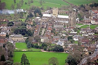
Wells is a city and civil parish in the Mendip district of Somerset, located on the southern edge of the Mendip Hills, 21 miles (34 km) south-east of Weston-super-Mare, 22 miles (35 km) south-west of Bath and 23 miles (37 km) south of Bristol. Although the population recorded in the 2011 census was only 10,536, and with a built-up area of just 3.244 square kilometres, Wells has had city status since medieval times, because of the presence of Wells Cathedral. Often described as England's smallest city, it is actually second smallest to the City of London in area and population, but unlike London it is not part of a larger urban agglomeration.

Bridgwater is a large historic market town and civil parish in Somerset, England. Its population currently stands at around 35,886 as of 2011. Bridgwater is at the edge of the Somerset Levels, in level and well-wooded country. The town lies along both sides of the River Parrett; it has been a major inland port and trading centre since the industrial revolution. Most of its industrial bases still stand today. Its larger neighbour, Taunton, is linked to Bridgwater via a canal, the M5 motorway and the GWR railway line.
Shepton Mallet is a market town and civil parish in the Mendip District of Somerset, England, some 16 miles (26 km) south-west of Bath, 18 miles (29 km) south of Bristol and 5 miles (8.0 km) east of Wells. It had an estimated population of 10,810 in 2019. Mendip District Council is based there. The Mendip Hills lie to the north and the River Sheppey runs through the town, as does the route of the Fosse Way, the main Roman road between north-east and south-west England. There is evidence of Roman settlement. Its listed buildings include a medieval parish church. Shepton Mallet Prison was England's oldest, but closed in March 2013. The medieval wool trade gave way to trades such as brewing in the 18th century. It remains noted for cider production. It is the closest town to the Glastonbury Festival and nearby the Royal Bath and West of England Society showground.

The Somerset Levels are a coastal plain and wetland area of Somerset, England, running south from the Mendips to the Blackdown Hills.

Taunton is the county town of Somerset, England, with a 2011 population of 69,570. Its thousand-year history includes a 10th-century monastic foundation, Taunton Castle, which later became a priory. The Normans built a castle owned by the Bishops of Winchester. Parts of the inner ward house were turned into the Museum of Somerset and Somerset Military Museum. For the Second Cornish uprising of 1497, Perkin Warbeck brought an army of 6,000; most surrendered to Henry VII on 4 October 1497. On 20 June 1685 the Duke of Monmouth crowned himself King of England here in a rebellion defeated at the Battle of Sedgemoor. Judge Jeffreys led the Bloody Assizes in the Castle's Great Hall. The Grand Western Canal reached Taunton in 1839 and the Bristol and Exeter Railway in 1842. Today it hosts Musgrove Park Hospital, Somerset County Cricket Club and the base of 40 Commando, Royal Marines. Taunton flower show has been held in Vivary Park since 1866. The United Kingdom Hydrographic Office is in Admiralty Way.
Sturminster Newton is a town and civil parish in the Blackmore Vale area of Dorset, England. It is situated on a low limestone ridge in a meander of the River Stour. The town is at the centre of a large dairy agriculture region, around which the town's economy is built. The larger part of the town (Sturminster) lies on the north side of the river, and includes most shops and services, whilst to the south is the smaller Newton. Between these two areas is a wide flood plain. The town was the home of poet and author William Barnes, and, for part of his life, Thomas Hardy. The town has 43 shops, a primary and secondary school, and a school and college catering for children with Special educational needs. In the 2011 census the town's civil parish had a population of 4,945.

The West Country is a loosely defined area of south-western England. The term usually encompasses the historic counties of Cornwall, Devon, Dorset, and Somerset and is often extended to include Wiltshire and Gloucestershire, in the South West region. Some definitions also include Herefordshire. The West Country is host to distinctive regional English dialects and accents, as well as to the Cornish language.
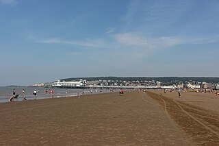
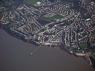
Weston-super-Mare, also known as Weston, is a seaside town in North Somerset, England. It lies by the Bristol Channel 20 miles (32 km) south west of Bristol between Worlebury Hill and Bleadon Hill. It includes the suburbs of Milton, Oldmixon, West Wick, Worlebury, Uphill and Worle. Its population at the 2011 census was 76,143. Since 1983, Weston has been twinned with Hildesheim in Germany.

Frome is a town and civil parish in eastern Somerset, England. The town is built on uneven high ground at the eastern end of the Mendip Hills, and centres on the River Frome. The town, about 13 miles (21 km) south of Bath, is the largest in the Mendip district of Somerset and is part of the parliamentary constituency of Somerton and Frome.
Clevedon is an English seaside town and civil parish in the unitary authority of North Somerset, part of the ceremonial county of Somerset. It recorded a parish population of 21,281 in the United Kingdom Census 2011, estimated at 21,442 in 2019. It lies along the Severn Estuary, among small hills that include Church Hill, Wain's Hill, Dial Hill, Strawberry Hill, Castle Hill, Hangstone Hill and Court Hill, a Site of Special Scientific Interest with overlaid Pleistocene deposits. It features in the Domesday Book of 1086. Clevedon grew in the Victorian period as a seaside resort and in the 20th century as a dormitory town for Bristol.

Wincanton is a small town and electoral ward in South Somerset, southwest England. The town lies off the A303 road, a main route between London and South West England, and has some light industry. The town and electoral ward has a population of 5,272.
The River Frome is a river in Somerset, England. It rises near Bungalow Farm on Cannwood Lane, south-west of Witham Friary, flows north through Blatchbridge to the town of Frome, and continues in a generally northerly direction passing between the eastern edge of the Mendip Hills and Trowbridge before joining the Bristol Avon at Freshford, below Bradford on Avon.

West Pennard is a village and civil parish east of Glastonbury, situated at the foot of Pennard Hill, in the Mendip district of Somerset, England. The parish includes the hamlets of Coxbridge and Woodlands.

Somerset is a county in the south west of England. It is a rural county and transport infrastructure has been significant in industrial development. There is some heavy industry particularly related to the defence technologies and the county has several centres for stone quarrying, although the coalfield is now closed.

The Grade I listed buildings in Somerset, England, demonstrate the history and diversity of its architecture. The ceremonial county of Somerset consists of a non-metropolitan county, administered by Somerset County Council, which is divided into five districts, and two unitary authorities. The districts of Somerset are West Somerset, South Somerset, Taunton Deane, Mendip and Sedgemoor. The two administratively independent unitary authorities, which were established on 1 April 1996 following the breakup of the county of Avon, are North Somerset and Bath and North East Somerset. These unitary authorities include areas that were once part of Somerset before the creation of Avon in 1974.
| | This article about an English company is a stub. You can help Wikipedia by expanding it. |