Administration
For the administration of the Reserve, the Council of the University of Costa Rica at San Ramón (known as West Branch) approved in Session No. 521 of June 9, 1993, the Standards for the management of the station Alberto Manuel Brenes Biological Reserve. Part of this article indicates that the RBAMB must be administered by a director, who shall be a professor at the headquarters of the west branch. In addition, there is an advisory committee called the General Advisory Committee and Technical Research Advisory Committee.
The General Advisory Committee consists of the Research Coordinator, the Director of the Department of Natural Sciences, the Director of the reserve, the director of the Biology Section and a professor of this section. Part of the activities of this Committee are: promoting and approving the different programs or operating plans for the management of the Reserve and determine the fees for the use of facilities and decide on the distribution of resources economic as well as improvements to be promoted in their facilities. The current director is Biologist M.Sc. Ronald Sánchez Porras.

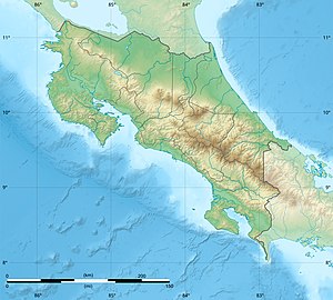
Costa Rica is located on the Central American Isthmus, surrounding the point 10° north of the equator and 84° west of the prime meridian. It has 212 km of Caribbean Sea coastline and 1,016 on the North Pacific Ocean.

Alajuela is a province of Costa Rica. It is located in the north-central part of the country, bordering Nicaragua to the north. It also borders the provinces of Heredia to the east, San José to the south, Puntarenas to the southwest and Guanacaste to the west. As of 2011, the province had a population of 885,571. Alajuela is composed of 16 cantons, which are divided into 111 districts. It covers an area of 9,757.53 square kilometers.
La Selva Biological Station is a protected area encompassing 1,536 ha of low-land tropical rain forest in northeastern Costa Rica. It is owned and operated by the Organization for Tropical Studies, a consortium of universities and research institutions from the United States, Costa Rica, and Puerto Rico. Recognized internationally as one of the most productive field stations in the world for tropical forest research and peer-reviewed publications, La Selva hosts approximately 300 scientists and 100 university courses every year. The primary goal of La Selva Biological Station is to preserve and protect an intact forest, as well as providing laboratory facilities for tropical research and education. The research potential of the area is not only vital to tropical ecology, but it is also an important location in the effort to study relations between local communities and protected areas. In addition, its high diversity and ease of access to the Puerto Viejo-Horquetas highway makes La Selva an important ecotourism destination and environmental education center for tourists and the local community.
National System of Conservation Areas is part of the Ministry of Environment and Energy (MINAE) of Costa Rica. It is the administrator for the nation's national parks, conservation areas, and other protected natural areas.
Braulio Carrillo National Park is a national park in Heredia Province, Cartago Province, Limón Province and San José Province, in central Costa Rica. It is part of the Central Conservation Area.

Arenal Tempisque Conservation Area, is an administrative area which is managed by SINAC for the purposes of conservation in the northwest part of Costa Rica, near the Arenal Volcano and covering part of the Cordillera de Tilarán and Cordillera de Guanacaste. It contains a number of National Parks, Wildlife refuges and Protected Zones. The area was previously known as Arenal Tilarán Conservation Area.

Caribbean La Amistad Conservation Area is an administrative area which is managed by SINAC for the purposes of conservation in the eastern part of Costa Rica, on the Caribbean coast. It contains several national parks, and a number wildlife refuges and other types of nature reserve.
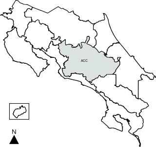
Central Conservation Area, is an administrative area which is managed by SINAC for the purposes of conservation in the central part of Costa Rica, notably the volcanic areas of the Cordillera Central. It contains six National Parks, several wildlife refuges and other types of nature reserves.
Chirripó National Park is a national park of Costa Rica, encompassing parts of three provinces: San José, Limón and Cartago. It was established in 1975.

San Ramón is a district in the canton of San Ramón in Alajuela Province in Costa Rica. The central municipality (distrito) of San Ramón covers an area of 1.29 km2 (0.50 sq mi) and has a population of 10,710. Together with adjoining distritos, it forms what is colloquially known as Ciudad de San Ramón. However, cities are no longer a valid administrative division in Costa Rica, by municipal codex law 7794 of April 30, 1998.

Zarcero is a canton in the Alajuela province of Costa Rica.
Craugastor andi is a species of rain frog in the family Craugastoridae which has not been seen since 1990. It is found in the Caribbean drainage of Costa Rica in the mountains and hills of the Cordillera Central and the far northeastern Cordillera de Talamanca, and in extreme northwestern Panama. Frank and Ramus (1995) give it the vernacular name Atlantic robber frog. It is known locally in Spanish by the generic names, used for many species, of rana de hojarasca, ranita or sapito.
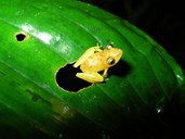
Pristimantis altae, also known as mountain robber frog, is a species of rain frog in the family Strabomantidae with a bright coral-coloured groin. It is found in Costa Rica and Panama.
Pristimantis caryophyllaceus is a species of frog in the family Strabomantidae. It is found in Costa Rica and Panama; records from Colombia prior to 2010 refer to Pristimantis educatoris. However, taxonomy of Pristimantis caryophyllaceus and P. educatoris remain unsettled, and many sources continue to report Pristimantis caryophyllaceus from Colombia.

The Monteverde Cloud Forest Reserve is a Costa Rican reserve located along the Cordillera de Tilarán within the Puntarenas and Alajuela provinces. Named after the nearby town of Monteverde and founded in 1972, the Reserve consists of over 10,500 hectares of cloud forest. It draws roughly 70,000 visitors a year. The reserve consists of 6 ecological zones, 90% of which are virgin forest. A high biodiversity area, consisting of over 2,500 plant species, 100 species of mammals, 400 bird species, 120 reptilian and amphibian species, and thousands of insects, has drawn both scientists and tourists alike.
San Vito, originally named San Vito de Java, is a district and head city of the Coto Brus canton, in the Puntarenas province of Costa Rica. It is located about 271 kilometres (168 mi) southeast of the capital San José, and close to the Panama border.

The San Carlos River is a river in the Alajuela Province of Costa Rica that drains into the San Juan River and thus into the Caribbean Sea. Its basin covers an area of about 3,100 km2. The river has a length of 142 km of which about 60 km allow navigation. The river originates from the confluence of the Jabillos River and Peje River both originating on the eastern side of the Cordillera de Tilarán and traverses the San Carlos Canton. It meets the San Juan River close to Boca San Carlos.

The Northwestern Andean montane forests (NT0145) is an ecoregion on the Andes mountains in the west of Colombia and Ecuador. Both flora and fauna are highly diverse due to effect of ice ages when the warmer climate zones were separated and the cooler ones combined, and interglacial periods when the reverse occurred. Because the environment is hospitable to humans, the habitat has been drastically modified by farming and grazing since the Pre-Columbian era.
Cojoba costaricensis, commonly known as angel's hair, lorito, or cabello de angel, is a species of plant in the family Fabaceae that is endemic to Costa Rica and Panama.