
The Au Sable River in Michigan, United States runs approximately 138 miles (222 km) through the northern Lower Peninsula, through the towns of Grayling and Mio, and enters Lake Huron at Au Sable. It is considered one of the best brown trout fisheries east of the Rockies and has been designated a blue ribbon trout stream by the Michigan Department of Natural Resources. In French, au sable literally means "at the sand." A 1795 map calls it the Beauais River.

Iosco County is a county in the U.S. state of Michigan; its eastern border is formed by Lake Huron. As of the 2010 census, the population was 25,887. The county seat is Tawas City.

Alcona County is a county of the U.S. state of Michigan. As of the 2010 census, the population was 10,942. Its county seat is Harrisville. Alphabetically it is the first county in Michigan; as its flag states, it is the "First of 83".

Alcona Township is a civil township of Alcona County in the U.S. state of Michigan. As of the 2010 census, the township population was 968.
Curtis Township is a civil township of Alcona County in the U.S. state of Michigan. The population was 1,236 at the 2010 census.
Greenbush Township is a civil township of Alcona County in the U.S. state of Michigan. The population was 1,409 at the 2010 census.

Harrisville is a city in the U.S. state of Michigan and the county seat of Alcona County. The population was 493 at the 2010 census, making Harrisville the sixth-smallest city by population in the state of Michigan. The city is surrounded by Harrisville Township but is administratively autonomous. Located on Lake Huron, it is an official Michigan Department of Natural Resources Harbor of Refuge.
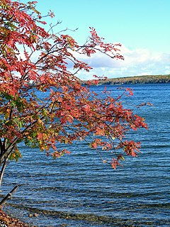
Hubbard Lake is a lake in Alcona County in Northern Michigan. The lake covers 8,850 acres (36 km²) and is seven miles (11 km) long (north-south) and two miles (3 km) wide. It has a maximum depth of 85 feet with an average depth of 32.6 feet. The lake spans three townships: Caledonia, Alcona, and Hawes.

The Boardman River is a 28.2-mile-long (45.4 km) river that flows into the west arm of Grand Traverse Bay in Traverse City, Michigan. The Boardman's upper tributaries rise near Kalkaska, Michigan, and its watershed drains an area of 295 square miles (760 km2) through 130 miles (210 km) of river and tributaries. The Boardman River is considered one of the top ten trout streams in Michigan. Before entering the Grand Traverse Bay, it becomes Boardman Lake, a natural lake that was originally 259 acres (1.05 km2) in size and increased to 339 acres (137 ha) after the Union Street Dam was constructed in 1867. After flowing through Boardman Lake, the river descends through downtown Traverse City, following a hairpin-shaped course to Grand Traverse Bay. This Traverse City section of the Boardman River is accessible by motorboat from the lakeshore up to a weir upstream from the lakeshore. A short distance upstream from the weir is the Union Street Dam, a small decommissioned mill dam located between Cass and Union streets. The river's principal tributaries are Kids Creek, Beitner Creek, Swainston Creek, and the North and South branches of the river.
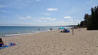
Harrisville State Park is a public recreation area covering 107 acres (43 ha) on the shore of Lake Huron off U.S. Route 23 in Harrisville and Harrisville Township, Alcona County, Michigan. The state park contains more than 100 acres of heavily forested land as well as a mile-long sandy beach. It is considered an important location for birders, with large and varied migratory populations of warblers and other song birds. The park is administered by the Michigan Department of Natural Resources.

The Manistee River in the U.S. state of Michigan, runs 190 miles (310 km) through the northwestern Lower Peninsula; it now passes through the contemporary villages of Sharon, Smithville, and Mesick, entering Lake Michigan at Manistee. It is considered, like the nearby Au Sable River, to be one of the best trout fisheries east of the Rockies.

The Sturgeon Point Light Station is a lighthouse on Lake Huron in Haynes Township, Alcona County, northeastern lower Michigan. Established to ward mariners off a reef that extends 1.5 miles (2.4 km) lakeward from Sturgeon Point, it is today regarded as a historic example of a Cape Cod style Great Lakes lighthouse.
The Roach River is a river in Piscataquis County, Maine. From the outlet of Third Roach Pond in Shawtown, the river runs 19.1 miles (30.7 km) west, through a chain of ponds. The Flow sequence through the ponds is from the Fourth Roach Pond through the Third Roach Pond, Second Roach Pond, and First Roach Pond to empty into Moosehead Lake, the source of the Kennebec River, in Spencer Bay. The Seventh Roach Pond drains through the Sixth Roach Pond in a separate tributary to the Third Roach Pond. No fifth Roach Pond is shown on modern maps.
The East Arm Little Calumet River, also known as the Little Calumet River East Branch, is a 22.1-mile-long (35.6 km) portion of the Little Calumet River that begins just east of Holmesville, Indiana in New Durham Township in LaPorte County and flows west to Porter County and the Port of Indiana-Burns Waterway.

Salt Creek is a 24.0-mile-long (38.6 km) tributary of the East Arm Little Calumet River that begins south of Valparaiso in Porter County, Indiana and flows north until it joins the East Arm Little Calumet River just before it exits to Lake Michigan via the Port of Indiana-Burns Waterway.

Harris Station Dam is a hydroelectric dam in Northeast Somerset, Somerset County, Maine. Also known as the Indian Pond Project, the dam was built from 1952 to 1954 as the largest hydroelectric dam in the state of Maine. It impounds the Kennebec River at the southern end of the natural Indian Pond, about 12 miles downstream from Moosehead Lake.
Eagle Lake is the first, largest, and deepest lake of the Allagash Wilderness Waterway in the North Maine Woods. The lake covers the eastern side of Eagle Lake township. The southern end of the lake extends into Maine township 7, range 12, where it receives overflow from Indian Pond, and into Soper Mountain township where it receives overflow from Haymock Lake via Smith Brook. Other ponds in the Eagle Lake watershed include Woodman Pond via Woodman Brook, Pillsbury Pond and Little Pillsbury Pond via Smith Brook, Soper Pond and Upper Soper Pond via Soper Brook, and the Russell Ponds via Russell Brook. Eagle Lake originally received overflow from Chamberlain Lake, but Lock Dam has diverted most Chamberlain Lake overflow through Telos Cut to the Penobscot River since the 1850s.
Caucomgomoc Lake is in the North Maine Woods at the corner of townships 6 and 7 in ranges 14 and 15. Loon Stream flows into the southern end of the lake from Loon Lake, Bear Pond, Big Hurd Pond, Little Hurd Pond, Bear Brook Pond, McDougal Pond, and tributaries from the southwest. Overflow from Little Shallow Lake through Shallow Lake, Daggett Pond, and Round Pond enters the east side of Caucomgomoc Lake through Ciss Stream. Smaller tributaries Avery Brook, Middle Brook, and Ramsell Brook flow into the north end of the lake. There is a dam at the lake outlet on the eastern shore a short distance south of Ciss Stream. Discharge through the dam flows down Caucomgomoc Stream through Black Pond and Chesuncook Lake to the West Branch Penobscot River at Ripogenus Gorge. White perch and yellow perch have largely replaced historic trout populations in the lake.
The Saint John Ponds are a chain of shallow lakes at the headwaters of the Baker Branch Saint John River in the North Maine Woods. The flow sequence is from the Upper First Saint John Pond, through the Lower First Saint John Pond, Second Saint John Pond, Third Saint John Pond, and Fourth Saint John Pond to the Fifth Saint John Pond. Flow from one pond to the next is sometimes called Baker Stream rather than the Baker Branch Saint John River. Great Northern Paper Company dug a canal from Fifth Saint John Pond 2 miles (3.2 km) eastward to the North Branch Penobscot River in 1939, and built a dam at the north end of Fifth Saint John Pond so pulpwood logs harvested in the upper Saint John River watershed could be floated down the Penobscot River to Millinocket, Maine. The canal and dam have fallen into disrepair so most drainage from the ponds again flows down the Saint John River. All upstream ponds with the exception of the first had dams to regulate discharge flow for log driving, but those dams have similarly fallen into disrepair. Moose use the ponds as summer refuge from heat and biting insects.

