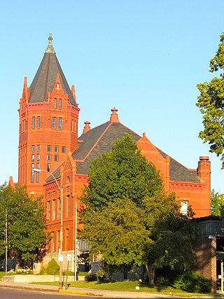
Marshall County is a county located in the U.S. state of Kansas. Its county seat and largest city is Marysville. As of the 2020 census, the county population was 10,038. The county was named after Frank J. Marshall, a state representative who operated the first ferry over the Big Blue River.
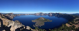
Crater Lake National Park is an American national park located in southern Oregon. Established in 1902, Crater Lake is the fifth-oldest national park in the United States and the only national park in Oregon. The park encompasses the caldera of Crater Lake, a remnant of Mount Mazama, a destroyed volcano, and the surrounding hills and forests.

Multnomah Falls is a waterfall located on Multnomah Creek in the Columbia River Gorge, east of Troutdale, between Corbett and Dodson, Oregon, United States. The waterfall is accessible from the Historic Columbia River Highway and Interstate 84. Spanning two tiers on basalt cliffs, it is the tallest waterfall in the state of Oregon at 620 ft (189 m) in height. The Multnomah Creek Bridge, built in 1914, crosses below the falls, and is listed on the National Register of Historic Places.

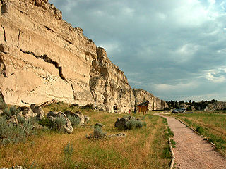
Scotts Bluff National Monument is located west of the City of Gering in western Nebraska, United States. This National Park Service site protects over 3,000 acres of historic overland trail remnants, mixed-grass prairie, rugged badlands, towering bluffs and riparian area along the North Platte River. The park boasts over 100,000 annual visitors.

Bandelier National Monument is a 33,677-acre (13,629 ha) United States National Monument near Los Alamos in Sandoval and Los Alamos counties, New Mexico. The monument preserves the homes and territory of the Ancestral Puebloans of a later era in the Southwest. Most of the pueblo structures date to two eras, dating between 1150 and 1600 AD.

The Santa Fe Trail was a 19th-century route through central North America that connected Franklin, Missouri, with Santa Fe, New Mexico. Pioneered in 1821 by William Becknell, who departed from the Boonslick region along the Missouri River, the trail served as a vital commercial highway until 1880, when the railroad arrived in Santa Fe. Santa Fe was near the end of El Camino Real de Tierra Adentro which carried trade from Mexico City. The trail was later incorporated into parts of the National Old Trails Road and U.S. Route 66.

Fort Kearny was a historic outpost of the United States Army founded in 1848 in the western U.S. during the middle and late 19th century. The fort was named after Col. and later General Stephen Watts Kearny. The outpost was located along the Oregon Trail near Kearney, Nebraska. The town of Kearney took its name from the fort. The "e" was added to Kearny by postmen who consistently misspelled the town name. A portion of the original site is preserved as Fort Kearny State Historical Park by the Nebraska Game and Parks Commission.

The Applegate Trail was an emigrant trail through the present-day U.S. states of Idaho, Nevada, California, and Oregon used in the mid-19th century by emigrants on the American frontier. It was originally intended as a less dangerous alternative to the Oregon Trail by which to reach the Oregon Territory. Much of the route was coterminous with the California Trail.

The Old Spanish Trail is a historical trade route that connected the northern New Mexico settlements of Santa Fe, New Mexico with those of Los Angeles, California and southern California. Approximately 700 mi (1,100 km) long, the trail ran through areas of high mountains, arid deserts, and deep canyons. It is considered one of the most arduous of all trade routes ever established in the United States. Explored, in part, by Spanish explorers as early as the late 16th century, the trail was extensively used by traders with pack trains from about 1830 until the mid-1850s.
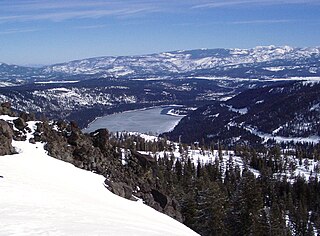
Donner Memorial State Park is a state park of California, US, preserving the site of the Donner Camp, where members of the ill-fated Donner Party were trapped by weather during the winter of 1846–1847. Caught without shelter or adequate supplies, members of the group resorted to cannibalism to survive. The Sierra Nevada site has been designated a National Historic Landmark. The state park contains the Emigrant Trail Museum and the Pioneer Monument dedicated to the travelers of the Emigrant Trail.

Wagon Bed Spring, also known historically as the Lower Spring or Lower Cimarron Spring, is a historic former spring in Grant County, Kansas, United States. It is located about 12 miles (19 km) south of Ulysses, on the west side of United States Route 270. In the 19th century it was an important watering spot on the Cimarron Cutoff of the Santa Fe Trail, where migrants on the trail often camped. The spring is now dry, primarily due to irrigation lowering the water table in the area. It was declared a National Historic Landmark in 1961.

Silver Falls State Park is a state park in the U.S. state of Oregon, located near Silverton, about 20 miles (32 km) east-southeast of Salem. It is the largest state park in Oregon with an area of more than 9,000 acres (36 km2), and it includes more than 24 miles (39 km) of walking trails, 14 miles (23 km) of horse trails, and a 4-mile (6.4 km) bike path. Its 8.7-mile (14.0 km) Canyon Trail/Trail of Ten Falls runs along the banks of Silver Creek and by ten waterfalls, from which the park received its name. Four of the ten falls have an amphitheater-like surrounding that allows the trail to pass behind the flow of the falls. The Silver Falls State Park Concession Building Area and the Silver Creek Youth Camp-Silver Falls State Park are separately listed on the U.S. National Register of Historic Places.

White Pines Forest State Park, more commonly referred to as White Pines State Park, is an Illinois state park in Ogle County, Illinois. It is located near the communities of Polo, Mount Morris and Oregon. The 385-acre (156 ha) park contains the southernmost remaining stand of native white pine trees in the state of Illinois, and that area, 43 acres (17 ha), was designated an Illinois Nature Preserve in 2001.

Oregon Trail Ruts State Historic Site is a preserved site of wagon ruts of the Oregon Trail on the North Platte River, about 0.5 miles south of Guernsey, Wyoming. The Oregon Trail here was winding up towards South Pass. Here, wagon wheels, draft animals, and people wore down the trail into a sandstone ridge about two to six feet, during its heavy usage from 1841–1869. The half-mile stretch is "unsurpassed" and is the best-preserved set of Oregon Trail ruts anywhere along its former length.

The Hollenberg Pony Express Station, also known as Cottonwood Pony Express Station, is the most intact surviving station of the Pony Express in the United States. It was built by Gerat H. Hollenberg in 1858, to serve travelers on the Oregon and California Trails, and was used by the Pony Express when it was established in 1860. The station is owned by the state of Kansas and is operated by the Kansas Historical Society as Hollenberg Pony Express Station State Historic Site. It was designated a National Historic Landmark in 1961.

Willamette Mission State Park is a state park in the U.S. state of Oregon, located about four miles (6 km) north of Keizer adjacent to the Wheatland Ferry and east of the Willamette River. It includes Willamette Station Site, Methodist Mission in Oregon, which is listed by the National Register of Historic Places.
Register Cliff is a sandstone cliff and featured key navigational landmark prominently listed in the 19th century guidebooks about the Oregon Trail, and a place where many emigrants chiseled the names of their families on the soft stones of the cliff — it was one of the key checkpoint landmarks for parties heading west along the Platte River valley west of Fort John, Wyoming which allowed travelers to verify they were on the correct path up to South Pass and not moving into impassable mountain terrains—geographically, it is on the eastern ascent of the Continental Divide leading upward out of the Great Plains in the east of the U.S. state of Wyoming. It is notable as a historic landmark for 'registering' hundreds of emigrants on the Oregon Trail who came to follow custom and inscribed their names on its rocks during the western migrations of the 19th century. An estimated 500,000 emigrants used these trails from 1843 to 1869, with up to one-tenth dying along the way, usually due to disease.

The Nobles Emigrant Trail, also known as the Fort Kearney, South Pass and Honey Lake Wagon Road, is a trail in California that was used by emigrant parties from the east as a shortened route to northern California. It was pioneered in 1851 by William Nobles, who discovered an easy shortcut between the Applegate Trail in Nevada and the Lassen Trail in California. The trail was extensively used until the 1870s, when it was superseded by railroads.

O'Fallons Bluff is a section of bluffs about 20 miles (32 km) long that run along the south side of the Platte river near Sutherland in Lincoln County, Nebraska. The Oregon and California trails ran up and over these bluffs. They were characterized by American pioneers heading west to Oregon and California as sparse in vegetation with a number of violent incidents involving Native Americans. In the early 1860s, a Pony Express station was located about 5 miles (8 km) west of where the wagon trails went up the bluff. During construction of Interstate 80, the steep part of the bluffs were cut away but wagon ruts remained, which are marked by iron hoops signifying wagon wheels. It was listed in the National Register of Historic Places in 1974.


