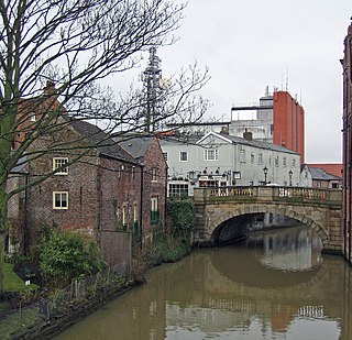
The River Foss is in North Yorkshire, England. It is a tributary of the River Ouse. It rises in the Foss Crooks Woods near Oulston Reservoir close to the village of Yearsley and runs south through the Vale of York to the Ouse in the centre of York. The name most likely comes from the Latin word Fossa, meaning ditch. It is mentioned in the Domesday Book. The York district was settled by Norwegian and Danish people, so parts of the place names could be old Norse. Referring to the etymological dictionary "Etymologisk ordbog", ISBN 82-905-2016-6 deals with the common Danish and Norwegian languages – roots of words and the original meaning. The old Norse word Fos (waterfall) means impetuous. The River Foss was dammed, and even though the elevation to the River Ouse is small, a waterfall was formed. This may have led to the name Fos which became Foss.

Headlam is a village in the borough of Darlington and the ceremonial county of County Durham, England. It lies to the west of Darlington. The population taken at the 2011 Census was less than 100. Details are included in the parish of Ingleton. The hamlet has 14 stone houses plus 17th-century Headlam Hall, now a country house hotel. The village is set around a village green with a medieval cattle-pound and an old stone packhorse bridge across the beck. Headlam is classed as Lower Teesdale and has views to the south as far as Richmond and to the Cleveland Hills in the east.
The River Leven in North Yorkshire, England is a tributary of the River Tees. It rises on Warren Moor, part of Kildale Moor, in the North York Moors and flows to the north of the moors to join the River Tees at Yarm.

Aldbrough St John is a village and civil parish in the Richmondshire district in North Yorkshire, England. The parish has a population of 325, increasing to 392 at the 2011 Census.

The River Wiske is a tributary of the River Swale in Yorkshire, England. The Wiske gives its name to several villages it passes through. The name Wiske is derived from an Old English word wisca meaning a water meadow. It was once known as the Foulbroke, a name for which some writers commented that it was well deserved.

The Balder is an English river that rises on the eastern slope of Stainmore Common in the Pennine Chain and flows eastwards for about 23.4 kilometres (14.5 mi), before joining the River Tees at Cotherstone.
Lunedale is the dale, or valley, of the River Lune, on the east side of the Pennines in England, west of Middleton-in-Teesdale. Its principal settlements are Grassholme, Thringarth and Bowbank.

The River Winster is a river in the English county of Cumbria. The Winster was the boundary between the ancient counties of Lancashire and Westmorland. It has a relatively small catchment area; other streams flow parallel to it on either side.

Glenderaterra Beck is a watercourse in the county of Cumbria, England. The length of the Glenderaterra, and its major tributary Whit Beck is 4.8 miles (7.8 km), which have a total catchment area of 11.8 square kilometres (4.6 sq mi).

Wycoller Beck is a stream in Lancashire, running through Wycoller Country Park and the village of Wycoller in Pendle. It is 3.76 miles (6.05 km) long and has a catchment area of 4.04 square miles (10.46 km2).

Barbon Beck is a small river in Barbondale, Cumbria. It is a tributary of the River Lune.

The River Rye in the English county of North Yorkshire rises just south of the Cleveland Hills, east of Osmotherley, and flows through Hawnby, Rievaulx, Helmsley, Nunnington, West and East Ness, Butterwick, Brawby, and Ryton, before joining the River Derwent at 54°10′N00°44′W near Malton.

Skirden Beck is a minor river in Lancashire, England. It is approximately 4.3 miles (6.85 km) long and has a catchment area of 18.87 square miles (48.882 km2).

Stock Beck is a minor river in the West Craven area of Pendle, Lancashire. It is 8.25 miles (13.27 km) long and has a catchment area of 14.41 square miles (3,731.89 ha).

Dacre Beck is a small river in Cumbria, England.
Risedale Beck is a small river that rises on Hipswell Moor, near Catterick Garrison in North Yorkshire, England. The name derives from Old Norse as meaning either Risi's Valley or translated as a valley overgrown with brushwood. Risedale Beck flows eastwards into Catterick Garrison as Leadmill Gill, which in turn flows into Colburn Beck, a tributary of the River Swale. The length of the beck from source to the River Swale is 6.5 miles (10.4 km).
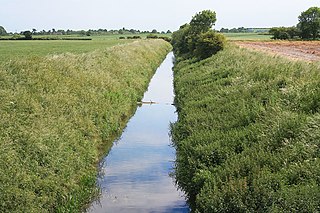
Barlings Eau is a small river near Barlings, Lincolnshire, England. It is a tributary of the River Witham, joining it near Short Ferry. It acts as the central spine for a number of other small rivers, which drain the low-lying land to either side. Most of its course is within the area managed by the Witham Third District IDB, an Internal Drainage Board responsible for land drainage. One of their pumping stations is on the banks of the river.

Piethorne Brook is a watercourse in Greater Manchester. It is a tributary of the River Beal.

The River Annas is a minor river in Cumbria in northwest England. It is formed as the Kinmont Beck and Crookley Beck which drain the southwestern fells of the Lake District, meet on the eastern edge of the village of Bootle. Their combined waters flow southwest towards Annaside on the Irish Sea coast. However longshore drift has diverted the river northwestwards parallel to the shore for a further 1.2 miles (2 km) so that it enters the sea at Selker. This section of river is followed by the Cumbria Coastal Way. The river is bridged by the A595 road and the Cumbrian coast railway line.

The River Rase is a 16 mile (25 km) long tributary of the River Ancholme that flows through Lincolnshire, in the east of England.
