
Fojutowo is a village in the administrative district of Gmina Tuchola, within Tuchola County, Kuyavian-Pomeranian Voivodeship, in north-central Poland. It lies approximately 15 kilometres (9 mi) north of Tuchola and 68 km (42 mi) north of Bydgoszcz.
Brukniewo is a village in the administrative district of Gmina Lubiewo, within Tuchola County, Kuyavian-Pomeranian Voivodeship, in north-central Poland.
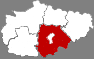
Dârmănești is a commune in Argeș County, in southern central Romania. It is composed of five villages: Dârmănești, Negreni, Piscani, Valea Nandrii and Valea Rizii.
Płaczki is a village in the administrative district of Gmina Nowa Brzeźnica, within Pajęczno County, Łódź Voivodeship, in central Poland. It lies approximately 6 kilometres (4 mi) south-west of Nowa Brzeźnica, 14 km (9 mi) south-east of Pajęczno, and 85 km (53 mi) south of the regional capital Łódź.
Brzostek is a village in the administrative district of Gmina Przedbórz, within Radomsko County, Łódź Voivodeship, in central Poland. It lies approximately 4 kilometres (2 mi) south-east of Przedbórz, 33 km (21 mi) east of Radomsko, and 87 km (54 mi) south of the regional capital Łódź.
Antoniów is a village in the administrative district of Gmina Bałtów, within Ostrowiec County, Świętokrzyskie Voivodeship, in south-central Poland. It lies approximately 5 kilometres (3 mi) north of Bałtów, 17 km (11 mi) north-east of Ostrowiec Świętokrzyski, and 67 km (42 mi) east of the regional capital Kielce.
Wiry is a village in the administrative district of Gmina Grębów, within Tarnobrzeg County, Subcarpathian Voivodeship, in south-eastern Poland. It lies approximately 3 kilometres (2 mi) east of Grębów, 16 km (10 mi) east of Tarnobrzeg, and 60 km (37 mi) north of the regional capital Rzeszów.
Kurpie Dworskie is a village in the administrative district of Gmina Troszyn, within Ostrołęka County, Masovian Voivodeship, in east-central Poland. It lies approximately 3 kilometres (2 mi) north-east of Troszyn, 13 km (8 mi) east of Ostrołęka, and 106 km (66 mi) north-east of Warsaw.
Rogotwórsk is a village in the administrative district of Gmina Drobin, within Płock County, Masovian Voivodeship, in east-central Poland.
Puchały is a village in the administrative district of Gmina Raszyn, within Pruszków County, Masovian Voivodeship, in east-central Poland. It lies approximately 3 kilometres (2 mi) south-west of Raszyn, 8 km (5 mi) east of Pruszków, and 11 km (7 mi) south-west of Warsaw.
Kaczory is a village in the administrative district of Gmina Wiśniew, within Siedlce County, Masovian Voivodeship, in east-central Poland. It lies approximately 3 kilometres (2 mi) south of Wiśniew, 13 km (8 mi) south of Siedlce, and 90 km (56 mi) east of Warsaw.
Pawłowice is a village in the administrative district of Gmina Żerków, within Jarocin County, Greater Poland Voivodeship, in west-central Poland. It lies approximately 3 kilometres (2 mi) south-west of Żerków, 10 km (6 mi) north of Jarocin, and 58 km (36 mi) south-east of the regional capital Poznań.
Polesie is a village in the administrative district of Gmina Rudniki, within Olesno County, Opole Voivodeship, in south-western Poland. It lies approximately 6 kilometres (4 mi) east of Rudniki, 27 km (17 mi) north-east of Olesno, and 67 km (42 mi) north-east of the regional capital Opole.
Hamerbark is a village in the administrative district of Gmina Stara Kiszewa, within Kościerzyna County, Pomeranian Voivodeship, in northern Poland. It lies approximately 8 kilometres (5 mi) north-west of Stara Kiszewa, 11 km (7 mi) south-east of Kościerzyna, and 49 km (30 mi) south-west of the regional capital Gdańsk.
Nosówko is a village in the administrative district of Gmina Białogard, within Białogard County, West Pomeranian Voivodeship, in north-western Poland. It lies approximately 12 kilometres (7 mi) north-east of Białogard and 123 km (76 mi) north-east of the regional capital Szczecin.
Żeleźno is a village in the administrative district of Gmina Białogard, within Białogard County, West Pomeranian Voivodeship, in north-western Poland. It lies approximately 8 kilometres (5 mi) north-east of Białogard and 121 km (75 mi) north-east of the regional capital Szczecin.
Krakowice is a village in the administrative district of Gmina Gryfice, within Gryfice County, West Pomeranian Voivodeship, in north-western Poland. It lies approximately 8 kilometres (5 mi) west of Gryfice and 63 km (39 mi) north-east of the regional capital Szczecin.
Strzeżenice is a village in the administrative district of Gmina Będzino, within Koszalin County, West Pomeranian Voivodeship, in north-western Poland. It lies approximately 5 kilometres (3 mi) north-east of Będzino, 11 km (7 mi) north-west of Koszalin, and 133 km (83 mi) north-east of the regional capital Szczecin.

Warwick is an unincorporated community in central Alberta within the County of Minburn No. 27, located 17 kilometres (11 mi) north of Highway 16, 96 kilometres (60 mi) east of Edmonton.
Zezhou County is a county in the southeast of Shanxi province, China, bordering Henan province to the south. It is under the administration of the prefecture-level city of Jincheng, and surrounds the latter's central Chengqu, or urban area. Its population is approximately 480,000. The area under its jurisdiction was known as the "Suburban District" (Jiaoqu) of Jincheng, until it changed its name to Zezhou County in 1998. It is accessible via the G55 Erenhot–Guangzhou Expressway.


