Alewife may refer to:
Alewife may refer to:

Somerville is a city located directly to the northwest of Boston, and north of Cambridge, in Middlesex County, Massachusetts, United States. As of the 2020 United States Census, the city had a total population of 81,045 people. With an area of 4.12 square miles (10.7 km2), the city has a density of 19,671/sq mi (7,595/km2), making it the most densely populated municipality in New England and the 19th most densely populated incorporated municipality in the country. Somerville was established as a town in 1842, when it was separated from Charlestown. In 2006, the city was named the best-run city in Massachusetts by The Boston Globe. In 1972, 2009, and 2015, the city received the All-America City Award. It is home to Tufts University, which has its campus along the Somerville and Medford border. Tufts, alongside Harvard University and the Massachusetts Institute of Technology, makes up one corner of the Brain Power Triangle, which thus includes the city of Somerville.

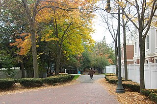
Davis Square is a major intersection in the northwestern section of Somerville, Massachusetts, United States, where several streets meet: Holland Street, Dover Street, Day Street, Elm Street, Highland Avenue, and College Avenue. The name is often used to refer to the West Somerville neighborhood surrounding the square as well.

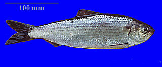
The alewife is an anadromous species of herring found in North America. It is one of the "typical" North American shads, attributed to the subgenus Pomolobus of the genus Alosa. As an adult it is a marine species found in the northern West Atlantic Ocean, moving into estuaries before swimming upstream to breed in freshwater habitats, but some populations live entirely in fresh water. It is best known for its invasion of the Great Lakes by using the Welland Canal to bypass Niagara Falls. Here, its population surged, peaking between the 1950s and 1980s to the detriment of many native species of fish. In an effort to control it biologically, Pacific salmon were introduced, only partially successfully. As a marine fish, the alewife is a US National Marine Fisheries Service "Species of Concern".

Alewife station is a Massachusetts Bay Transportation Authority (MBTA) intermodal transit station in the North Cambridge neighborhood of Cambridge, Massachusetts. It is the northwest terminal of the rapid transit Red Line and a hub for several MBTA bus routes. The station is at the confluence of the Minuteman Bikeway, Alewife Linear Park, Fitchburg Cutoff Path, and Alewife Greenway off Alewife Brook Parkway adjacent to Massachusetts Route 2, with a five-story parking garage for park and ride use. The station has three bike cages. Alewife station is named after nearby Alewife Brook Parkway and Alewife Brook, themselves named after the alewife fish.

The Minuteman Bikeway, also known as the Minuteman Commuter Bikeway, is a 10-mile (16-kilometre) paved multi-use rail trail located in the Greater Boston area of Massachusetts. It runs from Bedford to Alewife station, at the northern end of the Red Line in Cambridge, passing through the towns of Lexington and Arlington along the way. Also along the route are several notable regional sites, including Alewife Brook Reservation, the Cyrus Dallin Art Museum, Spy Pond, "Arlington’s Great Meadows", the Battle Green in Lexington, and Hanscom Air Force Base.

The Somerville Community Path is a paved rail trail in Somerville, Massachusetts, running 3.2 miles (5.1 km) from Massachusetts Avenue to East Cambridge via Davis Square. The first portion opened in 1985 along part of the former Fitchburg Cutoff rail line. Extensions opened in 1994 and 2015. A further 1.9-mile (3.1 km) extension to East Cambridge opened in June 2023 as part of the Green Line Extension project. It is a section of the partially completed Mass Central Rail Trail.

Interstate 695 was a planned six-lane auxiliary Interstate Highway in Boston, Massachusetts, that would have run through parts of Boston, Brookline, Cambridge, and Somerville.

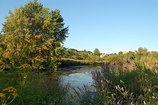
Alewife Brook Reservation is a Massachusetts state park and urban wild located in Cambridge, Arlington, and Somerville. The park is managed by the state Department of Conservation and Recreation and was established in 1900. It is named for Alewife Brook, which was also historically known as Menotomy River, a tributary of the Mystic River.

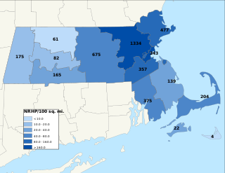
The National Register of Historic Places is a United States federal official list of places and sites considered worthy of preservation. In the state of Massachusetts, there are over 4,300 listings, representing about 5% of all NRHP listings nationwide and the second-most of any U.S. state, behind only New York. Listings appear in all 14 Massachusetts counties.

The Fitchburg Cutoff was a rail line running 2.8 miles (4.5 km) from Brighton Street in Belmont, Massachusetts, to Somerville Junction in Somerville, Massachusetts. It was constructed in two segments in 1870 and 1881 to connect the Lexington Branch and Central Massachusetts Railroad to the Boston and Lowell Railroad. Passenger service lasted until 1927. Freight service ended in 1979–80 to allow construction of the Red Line Northwest Extension; the line was abandoned in three sections in 1979, 1983, and 2007.
The Lexington and West Cambridge Railroad was a railroad company chartered in 1845 and opened in 1846 that operated in eastern Massachusetts. It and its successors provided passenger service until 1977 and freight service until 1980 or early 1981.

Alewife Brook Parkway is a short parkway in Cambridge and Somerville, Massachusetts. It is listed on the National Register of Historic Places. It begins at Fresh Pond in Cambridge, and heads north on the east bank of Alewife Brook, crossing into West Somerville and ending at the Mystic River on the Medford town line, where it becomes Mystic Valley Parkway. The entire length of Alewife Brook Parkway is designated as part of Massachusetts Route 16 (Route 16), while the southernmost sections are also designated as part of Route 2 and U.S. Route 3 (US 3). It is managed by the Department of Conservation and Recreation with the Massachusetts Department of Transportation responsible for bridge maintenance.

Mystic Valley Parkway is a parkway in Arlington, Medford, Somerville, and Winchester, Massachusetts, United States. It is listed on the National Register of Historic Places, and forms part of Route 16.

Johnnie's Foodmaster, more commonly known as simply Foodmaster, was a chain of supermarkets in the Boston Metro Area. It had its headquarters in Chelsea, Massachusetts and all stores were located in the state. On November 18, 2012, all ten stores closed, with six leases being transferred to Austin, Texas–based Whole Foods Market, and two to Quincy–based Stop & Shop; the future of the remaining locations was unknown at the time of closure.

The Mystic Water Works, also called the Mystic Pumping Station, is a historic water works at Alewife Brook Parkway and Capen Street in Somerville, Massachusetts. Built in 1862–65 by the city of Charlestown, it is a significant example of a mid-19th century waterworks facility. The building has been listed twice on the National Register of Historic Places. The first, in 1989, is part of the city of Somerville's listings, and was made under the name "Mystic Water Works". The second is part of an umbrella listing covering the entire historic water works system of Greater Boston, and was made in 1990, listed as the "Mystic Pumping Station".

North Cambridge, also known as "Area 11", is a neighborhood of Cambridge, Massachusetts bounded by Porter Square and the Fitchburg Line railroad tracks on the south, the city of Somerville on the northeast, Alewife Brook and the town of Arlington on the northwest, and the town of Belmont on the west. In 2005 it had a population of 10,642 residents living in 4,699 households, and the average income was $44,784. In 2010, the racial demographics for the neighborhood were 57.6% White, 20% Black, 15.1% Asian/Pacific Islander, 7.3% Hispanic origin, 0.3% Native American, 2.4% other race.

The Mystic River Reservation is a publicly owned nature preserve with recreational features located along the Mystic River in the towns of Winchester, Arlington, Medford, Somerville, Everett, and Chelsea in eastern Massachusetts. The reserve is part of the nearly 76-square-mile (200 km2) Mystic River watershed. It is managed by the Massachusetts Department of Conservation and Recreation.

Route 16 is a 59.8646-mile-long (96.3427 km) east–west state highway in Massachusetts. It begins in the west at an intersection with Route 12 and Route 193 in Webster, just north of the Connecticut state border. It runs in a generally southwest-northeast routing through a number of Boston's suburbs and runs to the west and then north of the city before ending in Revere at an intersection with Route 1A and Route 60.

George Dilboy Memorial Stadium is a multi-purpose public sports stadium in the city of Somerville, Massachusetts. It is the home of the Somerville Rampage semi-pro men's football team, the Boston Renegades semi-pro women's football team, as well as teams from Somerville High School, Saint Clement High School, and Matignon High School.

The Massachusetts Bay Transportation Authority operates subway, bus, commuter rail, and ferry service in the Greater Boston region. Boston has some of the highest rates of non-motorized commuting in the United States, including high bicycle usage. The MBTA offers certain provisions for riders wishing to make part of their trips by bicycle. The agency allows bicycles to be carried on all fixed-route services except the Green Line and the Ashmont-Mattapan High Speed Line light rail lines, although they are restricted on the commuter rail and heavy rail subway services at peak hours. Bicycle storage areas are offered at many stations, with "Pedal and Park" locking bicycle cages at certain high-usage stations.