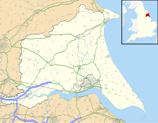
The East Riding of Yorkshire, often shortened to the East Riding and alternatively known as East Yorkshire, is a ceremonial county in the Yorkshire and the Humber region of England. It borders North Yorkshire to the north and west, South Yorkshire to the south-west, and Lincolnshire to the south across the Humber Estuary. The city of Kingston upon Hull is the largest settlement.

Bridlington is a seaside town and civil parish in the East Riding of Yorkshire, England. It is on the Holderness part of the Yorkshire Coast by the North Sea. The town is about 28 miles (45 km) north of Hull and 34 miles (55 km) east of York. The stream called Gypsey Race flows through the town and enters the North Sea at the harbour.

John Robert Mortimer was an English corn-merchant and archaeologist who lived in Driffield, East Riding of Yorkshire.

The Borough of East Yorkshire was one of nine local government districts of the county of Humberside, England, from 1 April 1974 to 1 April 1996.

Driffield, also known as Great Driffield, is a market town and civil parish in the East Riding of Yorkshire, England. The civil parish is formed by the town of Driffield and the village of Little Driffield. By road, it is 53 miles (85 km) north-east of Leeds, 29 miles (47 km) east of York and 23 miles (37 km) north of Hull.

Burton Agnes is a village and civil parish in the East Riding of Yorkshire, England. It is situated on the A614 road midway between Driffield and Bridlington.

Kilham is a village and civil parish in the East Riding of Yorkshire, England. It is situated about 5 miles (8 km) north-east of Driffield town centre. According to the 2011 UK census, Kilham parish had a population of 1,088, an increase on the 2001 UK census figure of 1,010.

Harpham is a small village and civil parish in the East Riding of Yorkshire, England. It is located just south of the A614 road, approximately 5 miles (8 km) north-east of Driffield and 7 miles (11 km) south-west of Bridlington.
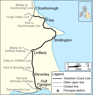
The Hull–Scarborough line, also known as the Yorkshire Coast Line, is a railway line in Yorkshire, England that is used primarily for passenger traffic. It runs northwards from Hull Paragon via Beverley and Driffield to Bridlington, joining the York–Scarborough line at a junction near Seamer before terminating at Scarborough railway station.

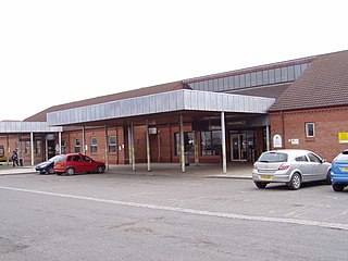
Driffield railway station serves the town of Driffield in the East Riding of Yorkshire, England. It is located on the Yorkshire Coast Line and is operated by Northern, providing all passenger train services.

The Malton and Driffield Junction Railway, later known as the Malton and Driffield branch was a railway line in Yorkshire that ran between the towns of Malton, North Yorkshire and Driffield in the East Riding of Yorkshire.

The York–Beverley line was a railway line between York, Market Weighton and Beverley in Yorkshire, England. The line was sanctioned in 1846 and the first part, the York to Market Weighton Line opened in 1847. Construction of the second part to Beverley was delayed for 17 years in part by the downfall of George Hudson, and a less favourable financial environment following the collapse of the 1840s railway bubble; the North Eastern Railway revived and completed the scheme in the 1860s; the Market Weighton to Beverley Line opened in 1865.
The East Riding of Yorkshire is a local government district with unitary authority status, and is a ceremonial county of England. It is named after the historic East Riding of Yorkshire which was one of three ridings alongside the North Riding and West Riding, which were constituent parts a Yorkshire ceremonial and administrative county until 1974. From 1974 to 1996 the area of the modern East Riding of Yorkshire constituted the northern part of Humberside.

East Riding College is a further education college located in the East Riding of Yorkshire, England.

East Riding General Hospital was a health facility in Bridlington Road, Driffield, East Riding of Yorkshire, England.
Bridlington Hospital is a health facility in Bessingby Road, Bridlington, East Riding of Yorkshire, England. It is managed by York and Scarborough Teaching Hospitals NHS Foundation Trust.

Lloyd Hospital was a community hospital in Quay Road, Bridlington, East Riding of Yorkshire, England. The remaining structure, known as "Medina House", is a Grade II listed building.

Avenue Hospital was a health facility in Westgate, Bridlington, East Riding of Yorkshire, England. The remaining structure is a Grade II* listed building.

Hornsea Cottage Hospital is a health facility in Eastgate, Hornsea, East Riding of Yorkshire, England.