
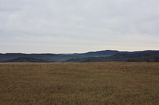
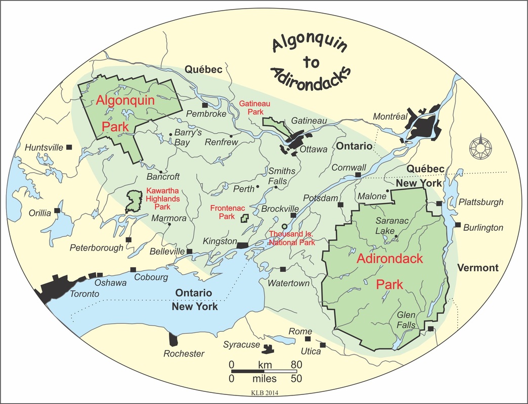
The Thousand Islands – Frontenac Arch region or the Frontenac Axis is an exposed strip of Precambrian rock in Canada and the United States that links the Canadian Shield from Algonquin Park with the Adirondack Mountain region in New York, an extension of the Laurentian mountains of Québec. The Algonquin to Adirondacks region, which includes the Frontenac Axis or Arch, is a critical linkage for biodiversity and resilience, and one with important conservation potential. The axis separates the St. Lawrence Lowlands and the Great Lakes Lowlands. It has many distinctive plant and animal species. It is one of four ecoregions of the Mixedwood Plains.

Algonquin Provincial Park is an Ontario provincial park located between Georgian Bay and the Ottawa River, mostly within the Unorganized South Part of Nipissing District. Established in 1893, it is the oldest provincial park in Canada. Additions since its creation have increased the park to its current size of about 7,653 km2 (2,955 sq mi). The park is contiguous with several smaller, administratively separate provincial parks that protect important rivers in the area, resulting in a larger total protected area.

The Adirondack Park is a multi-use park in northeastern New York protecting the Adirondack Mountains. The park was established in 1892 for "the free use of all the people for their health and pleasure", and for watershed protection. At 6.1 million acres, it is the largest park in the contiguous United States.
Ontario Parks is a branch of the Ministry of the Environment, Conservation and Parks in Ontario, Canada, that protects significant natural and cultural resources in a system of parks and protected areas that is sustainable and provides opportunities for inspiration, enjoyment and education. The Ontario Parks system covers over 78,000 square kilometres (30,000 sq mi), which is about 10 per cent of the province's surface area or the equivalent of an area approximately equal to Nova Scotia. It falls under the responsibility and mandate of the province's Ministry of the Environment, Conservation and Parks. It was formerly under the mandate of the Ministry of Natural Resources and Forestry.

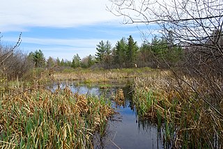
Frontenac Provincial Park is a provincial park located near the town of Sydenham, north of Kingston, Ontario, Canada. This 5,350-hectare park is classified as a natural environment park, and lies on the Frontenac Axis, a topographic extension of the Canadian Shield connecting to the Adirondack Mountains. It features 22 lakes, over 700 species, and extensive areas of mixed forest, wetlands, and granite outcrops.
The Canadian Parks and Wilderness Society (CPAWS) (French: la Société pour la nature et les parcs du Canada (SNAP)) was founded in 1963 to help protect Canada's wilderness.
Yellowstone to Yukon Conservation Initiative or Y2Y is a transboundary Canada–United States not-for-profit organization that aims to connect and protect the 2,000 miles Yellowstone-to-Yukon region. Its mission proposes to maintain and restore habitat integrity and connectivity along the spine of North America's Rocky Mountains stretching from the Greater Yellowstone ecosystem to Canada's Yukon Territory. It is the only organization dedicated to securing the long-term ecological health of the region.

Protected areas of Canada consist of approximately 12.1 percent of the nation's landmass and freshwater are considered conservation areas, including 11.4 percent designated as protected areas. Approximately 13.8 percent of Canada's territorial waters are conserved, including 8.9 percent designated as protected areas. Terrestrial areas conserved have increased by 65 percent in the 21st century, while marine areas conserved have increased by more than 3,800 percent.

Bush Heritage Australia is a non-profit organisation with headquarters in Melbourne, Australia, that operates throughout Australia. It was previously known as the Australian Bush Heritage Fund. Its vision is: Healthy Country, Protected Forever.
An Area of Natural and Scientific Interest is an official designation by the provincial Government of Ontario in Canada applied to contiguous geographical regions within the province that have geological or ecological features which are significantly representative provincially, regionally, or locally. Some sites with this designation were assessed through the International Biological Program between 1964 and 1974. As of 2014, over 1000 sites covering 460,000 hectares (4,600 km2) have been designated in the province.
The Opeongo Hills are a range of hills in Southern Ontario, near Algonquin Provincial Park. The hills stretch from Opeongo Lake in Algonquin Park in the west, along the Madawaska and Opeongo Rivers, towards the Opeongo Colonization Road, and extending towards the Deacon Escarpment, Bonnechere, Ontario, and Dacre in the east. To the east of the Opeongo Hills lie the Madawaska River valley, the Mississippi River Valley, and the Ottawa-Bonnechere Graben along the Ottawa River. Its tallest peak is roughly 7 km northeast of Highway 60. At roughly 586 meters, it is the tallest point in Southern Ontario. The community of Foymount is one of the highest settlements in Southern Ontario.

The Wildlands Network was created in 1991 to stem the tide of species extinctions that was being recorded across North America. Evidence that such extinctions were often exacerbated by a lack of habitat connectivity between existing protected areas resulted in the organization’s adoption of a primary mission focused on scientific and strategic support for creation of “networks of people protecting networks of connected wildlands.”

Harvey Locke is a Canadian conservationist, writer, and photographer. He is a recognized global leader in the field of parks, wilderness, wildlife and large landscape conservation. He is a founder of the Yellowstone to Yukon Conservation Initiative, with the goal to create a continuous corridor for wildlife from Yellowstone National Park in the United States to the Yukon in Northern Canada. In 2017, Locke was appointed chair of the IUCN World Commission on Protected Areas Beyond the Aichi Targets Task Force, with the goal of ensuring the new global conservation targets set at the next Conference of the Parties of the Convention on Biological Diversity in 2020 are meaningful for achieving the conservation of nature and halting of biodiversity loss.

The eastern forest–boreal transition is a temperate broadleaf and mixed forests ecoregion of North America, mostly in eastern Canada. It is a transitional zone or region between the predominantly coniferous Boreal Forest and the mostly deciduous broadleaf forest region further south.

The Frankfurt Zoological Society (FZS) is an international conservation organization founded in 1858 with headquarters in Frankfurt am Main, Germany. FZS focuses on maintaining biodiversity and conserving wildlife and ecosystems in protected areas and outstanding wild places. FZS leads and supports about 30 projects in 18 countries. Bernhard Grzimek, renowned German zoo director, zoologist, book author, editor, and animal conservationist in postwar West-Germany, served as president of the Frankfurt Zoological Society for over forty years.

Chicago Wilderness Alliance is a regional alliance of more than 250 different organizations that work together to improve the quality of life of the individuals and the many other species living in the Chicago (Illinois) area. Through the restoration and sustenation of the biological diversity that once encompassed the lands, their fundamental objective, to preserve the naturally occurring lands and waters in that region, is being made a reality. Through these activities, Chicago Wilderness played a major role in protecting and replenishing the naturally occurring ecosystems in the Chicago area as well as motivating people to become more aware and involved in the preservation of these lands and waters. Chicago Wilderness had continued to blossom through the funding and donations of many sources including private contributions, the member organizations, and state and federal grants.
The Wildlife Conservation Society Canada, based in Toronto, Ontario, is the Canadian affiliate of the Wildlife Conservation Society International (WCS), incorporated as a conservation organization in Canada in July 2004. WCS Canada currently runs conservation projects across six key regions in Canada led by its staff of field-based scientists.

The Frontenac Arch Biosphere Reserve is a UNESCO Biosphere Reserve located in southeastern Ontario, Canada. The biosphere reserve was designated in 2002, and is one of 16 biosphere reserves in Canada. The Frontenac Arch Biosphere operates primarily within a 2,700 km2. region from Brockville to Kingston, extending north to Verona and Perth.
The Carp Hills are a small range of rocky hills between the shallow valleys of the Carp River and Constance Creek, entirely within the West Carleton-March Ward of Canada's capital, Ottawa, Ontario. It runs roughly from Kinburn Side Road southeast to the village of Carp and the South March Highlands at March Road.


