
Bareilly division is an administrative geographical unit of Uttar Pradesh state of India. Bareilly is the administrative headquarters of the division. Bareilly division has three major cities in west Uttar Pradesh - Bareilly, Badaun, Pilibhit and Shahjahanpur.

Coimbra District is located in the Centro Region, the district capital is the city of Coimbra.
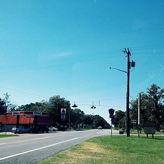
Olustee is an unincorporated community in Baker County, Florida, United States. The name "Olustee" is from the nearby Olustee Creek whose name derives from the Creek (Muscogee) language ue-lvste (/oy-lást-i/) meaning "black water". The town was historically known as Olustee Station and is the location of the Olustee Battlefield Historic State Park and of the ranger station for the Osceola National Forest, which is headquartered there. The US Forest Service has restored the former railroad depot at the center of town as a visitor center and museum for forest visitors.
Bielawy is a village in the administrative district of Gmina Janowiec Wielkopolski, within Żnin County, Kuyavian-Pomeranian Voivodeship, in north-central Poland.
Depułtycze Królewskie-Kolonia is a village in the administrative district of Gmina Chełm, within Chełm County, Lublin Voivodeship, in eastern Poland.
Górki Łubnickie is a village in the administrative district of Gmina Piątek, within Łęczyca County, Łódź Voivodeship, in central Poland.

Zamanlı is a village in the Gadabay Rayon of Azerbaijan. The village forms part of the municipality of Mormor.
Nowy Holeszów is a village in the administrative district of Gmina Hanna, within Włodawa County, Lublin Voivodeship, in eastern Poland, close to the border with Belarus.

Kornacice is a village in the administrative district of Gmina Opatów, within Opatów County, Świętokrzyskie Voivodeship, in south-central Poland. It lies approximately 3 kilometres (2 mi) north of Opatów and 58 km (36 mi) east of the regional capital Kielce.
Wszechświęte is a village in the administrative district of Gmina Sadowie, within Opatów County, Świętokrzyskie Voivodeship, in south-central Poland. It lies approximately 5 kilometres (3 mi) east of Sadowie, 7 km (4 mi) north of Opatów, and 58 km (36 mi) east of the regional capital Kielce.
Podrózie is a village in the administrative district of Gmina Działoszyce, within Pińczów County, Świętokrzyskie Voivodeship, in south-central Poland. It lies approximately 8 kilometres (5 mi) north of Działoszyce, 19 km (12 mi) south-west of Pińczów, and 55 km (34 mi) south of the regional capital Kielce.
Bałki is a village in the administrative district of Gmina Repki, within Sokołów County, Masovian Voivodeship, in east-central Poland.
Ruszkowo-Parcel is a village in the administrative district of Gmina Wierzbinek, within Konin County, Greater Poland Voivodeship, in west-central Poland. It lies approximately 7 kilometres (4 mi) west of Wierzbinek, 26 km (16 mi) north-east of Konin, and 103 km (64 mi) east of the regional capital Poznań.
Piorunów is a village in the administrative district of Gmina Władysławów, within Turek County, Greater Poland Voivodeship, in west-central Poland. It lies approximately 5 kilometres (3 mi) north-west of Władysławów, 14 km (9 mi) north of Turek, and 108 km (67 mi) east of the regional capital Poznań.
Gajówka is a village in the administrative district of Gmina Sośnicowice, within Gliwice County, Silesian Voivodeship, in southern Poland.
Warblewo is a village in the administrative district of Gmina Słupsk, within Słupsk County, Pomeranian Voivodeship, in northern Poland. It lies approximately 11 kilometres (7 mi) south-east of Słupsk and 95 km (59 mi) west of the regional capital Gdańsk.
Salpik is a village in the administrative district of Gmina Kętrzyn, within Kętrzyn County, Warmian-Masurian Voivodeship, in northern Poland. It lies approximately 13 kilometres (8 mi) south-east of Kętrzyn and 71 km (44 mi) east of the regional capital Olsztyn.
Wężnik is a village in the administrative district of Gmina Krzęcin, within Choszczno County, West Pomeranian Voivodeship, in north-western Poland. It lies approximately 4 kilometres (2 mi) west of Krzęcin, 9 km (6 mi) south of Choszczno, and 67 km (42 mi) south-east of the regional capital Szczecin.

Šabanci (Ilijaš) is a village in the municipality of Ilijaš, Bosnia and Herzegovina.
Boljevac is a village in the municipality of Kruševac, Serbia. According to the 2002 census, the village has a population of 151 people.


