Thurstaston Common is an area of almost 250 acres (100 ha) of parklands, wood and heath between Frankby and Thurstaston, on the Wirral Peninsula in North West England. The common is jointly owned by the National Trust and the Metropolitan Borough of Wirral. Royden Country Park is nearby and offers additional facilities.
Yanal Bog is a 1.6 hectare biological Site of Special Scientific Interest on the southern edge of the North Somerset Levels, just north of the village of Sandford, North Somerset. It was notified as an SSSI in 1988.

Scotstown Moor is in the north of Aberdeen, Scotland.
The South Pennine Moors are areas of moorland in the South Pennines in northern England. The designation is applied to two different but overlapping areas, a Site of Special Scientific Interest (SSSI) covering a number of areas in West Yorkshire, North Yorkshire, Lancashire and Greater Manchester, and a much larger Special Area of Conservation (SAC) covering parts of Derbyshire, South Yorkshire and West Yorkshire, and small areas of Cheshire, Staffordshire, Greater Manchester, Lancashire and North Yorkshire.

Cors Caron is a raised bog in Ceredigion, Wales. Cors is the Welsh word for "bog". Cors Caron covers an area of approximately 349 hectares. Cors Caron represents the most intact surviving example of a raised bog landscape in the United Kingdom. About 44 different species groups inhabit the area including various land and aquatic plants, fish, insects, crustaceans, lichen, fungi, terrestrial mammals and birds.

Hatfield Moors is a 1400.7 hectare biological site of Special Scientific Interest in South Yorkshire. The site was notified in 1954. The site is managed by Natural England.
Sound Heath, also known as Sound Common, is an area of common land in Sound, near Nantwich in Cheshire, England, which includes heathland, grassland, scrub, woodland and wetland habitats. The majority of the area is designated a Site of Special Scientific Interest and a Local Nature Reserve.

Pow Hill Bog is a Site of Special Scientific Interest in the Wear Valley district of County Durham, England. It lies alongside Derwent Reservoir, approximately 2 km north-west of the village of Edmundbyers and adjacent to the Edmundbyers Common portion of the Muggleswick, Stanhope and Edmundbyers Commons and Blanchland Moor SSSI.

Decoy Pit, Pools and Woods is a 17.7-hectare (44-acre) biological Site of Special Scientific Interest south of Aldermaston in Berkshire. An area of 8 hectares is a nature reserve called Decoy Heath, which is managed by the Berkshire, Buckinghamshire and Oxfordshire Wildlife Trust.

Cefn Blaenau is a 23-hectare Site of Special Scientific Interest in a small upland valley in Carmarthen and Dinefwr, Wales. It was designated an SSSI in 1989, primarily for its flush and spring vegetation as well as the diverse mosaic of unimproved pasture, ‘ffridd’ land, marshy grassland, wet heath, acid grassland, broadleaved woodland, streams, and small rock outcrops. These habitats, which are well represented at this site, have been greatly reduced in north Carmarthenshire due to land improvement, agricultural intensification, and afforestation. Only about 140 hectares of flush and spring vegetation remain in the county.

Roydon Common is a 194.9-hectare (482-acre) biological Site of Special Scientific Interest east of King's Lynn in Norfolk. It is also a Grade I Nature Conservation Review site, a National Nature Reserve and a Ramsar site. It is part of the Roydon Common and Dersingham Bog Special Area of Conservation and Roydon Common and Grimston Warren nature reserve, which is managed by the Norfolk Wildlife Trust,

Mitcheldean Meend Marsh is a 0.7-hectare (1.7-acre) nature reserve in Gloucestershire in the Forest of Dean. The site is listed in the 'Forest of Dean Local Plan Review' as a Key Wildlife Site (KWS).
Gweunydd Blaencleddau is a large wetland complex in a shallow south-west valley around the headwaters of the Eastern Cleddau river. It is a Site of Special Scientific Interest (SSSI) and a Special Area of Conservation (SAC) situated in Pembrokeshire, South Wales.

Bricket Wood Common is a 70 hectare open space and biological Site of Special Scientific Interest in Bricket Wood in Hertfordshire. It is managed by St Albans City and District Council together with the Countryside Management Service and Bricket Wood Joint Management Committee.

Allendale Moors is a Site of Special Scientific Interest (SSSI) in Northumberland, England. The upland moorland ridge site is listed for its heath, flush and upland grassland which provide a habitat for a nationally important assemblage of moorland breeding birds.

Bewick and Beanley Moors is the name given to a Site of Special Scientific Interest (SSSI) in north Northumberland, in the north-east of England. The moors are asserted to be of national importance by Natural England for the extent, quality and diversity of upland types including heaths, fens, wet grassland, flushes, mires and blanket bogs, together creating an extensive mosaic habitat supporting an exceptional community of amphibians. The moors are important, too, for their relict juniper woodland and scrub.

Ulverscroft Valley is a 110.8 hectares biological Site of Special Scientific Interest north-west of Markfield in Leicestershire. The site is in five separate blocks, and two areas are nature reserves managed by the Leicestershire and Rutland Wildlife Trust (LRWT). Lea Meadows is owned by the LRWT and it is also a scheduled monument. Part of Ulverscroft Nature Reserve is owned by the LRWT and part is owned by the National Trust and leased to the LRWT.
Farnham Mires is a Site of Special Scientific Interest, or SSSI, to the east of the village of Farnham, North Yorkshire, England. It consists of a spring-fed marshy fen or mire with reeds and sedge, and drier calcareous grassland containing a diverse range of flora. It has a history of poaching and fox hunting, but since the late 19th century, the attention of botanists has been drawn to its large variety of flowering plants. It has received some consideration on this account since 1944, and from 1954 it was designated SSSI status. This site has no facilities, and is not open to the public.

Bishop Monkton Ings is a Site of Special Scientific Interest, or SSSI, situated east of Bishop Monkton village in North Yorkshire, England. It consists mostly of marshy, calcareous grassland, with some broadleaved woodland, and some fen alongside the two watercourses which run through the site. This varied wetland forms a habitat for a variety of plants, including the semi-parasitic marsh lousewort (Pedicularis palustris).

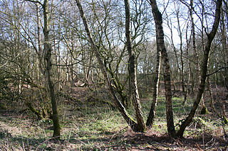
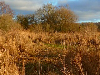
Mar Field Fen is a Site of Special Scientific Interest, or SSSI, north of Masham, North Yorkshire, England, in a rural area known as Marfield. It is situated on land containing woodland carr, fen, spring-fed marshy grassland and drier calcareous grassland, between the River Ure to the east and Marfield Wetland nature reserve to the west. As "one of the best examples of fen habitat in the Vale of York," it is a protected habitat for a variety of plants, including the common butterwort, a carnivorous plant. There is no public access to this site.