Alligator Bay is a swamp in the U.S. state of Georgia. [1]
Alligator Bay was named after the American alligator. [2]
Alligator Bay is a swamp in the U.S. state of Georgia. [1]
Alligator Bay was named after the American alligator. [2]

Cadwell is a town in Laurens County, Georgia, United States. The population was 528 at the 2010 census, up from 329 at the 2000 census. It is part of the Dublin Micropolitan Statistical Area.
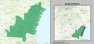
Georgia's 1st congressional district is a congressional district in the U.S. state of Georgia. It is currently represented by Republican Buddy Carter, though the district's boundaries have been redrawn following the 2010 United States Census, which granted an additional congressional seat to Georgia. The first election using the new district boundaries were the 2012 congressional elections.
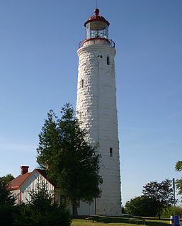
The Imperial Towers of Ontario were six of the earliest lighthouses built on Lake Huron and Georgian Bay, all constructed primarily of stone, by the Province of Canada. The origin of the designation Imperial is not certain, but some historians speculate that because the towers were public construction built under the colonial administration while Canada was a self-governing colony of Britain, the name would assure at least some funding from the British Empire's Board of Trade.
Interstate 75 (I-75) is a part of the Interstate Highway System and runs from the Hialeah–Miami Lakes border, a few miles northwest of Miami, to Sault Ste. Marie in the Upper Peninsula of Michigan. I-75 begins its national northward journey near Miami, running along the western parts of the Miami metropolitan area before traveling westward across Alligator Alley, resuming its northward direction in Naples, running along Florida's Gulf Coast, and passing the cities of Fort Myers, Punta Gorda, Venice, and Sarasota. The freeway passes through the Tampa Bay Area before turning inward towards Ocala, Gainesville, and Lake City before leaving the state and entering Georgia. I-75 runs for 471 miles (758 km) in Florida, making it the longest Interstate in the state and also the longest in any state east of the Mississippi River. The Interstate maintains a speed limit of 70 mph (110 km/h) for its entire length in Florida.

Wassaw Island is one of the Sea Islands. It is located on the Atlantic Ocean off the coast of the U.S. state of Georgia and is within the borders of Chatham County of that state. The island and its surrounding marshlands are part of the Wassaw National Wildlife Refuge, which has a total area of 10,053 acres (40.68 km2) of marsh, mudflats, and tidal creeks, including approximately 7 miles (11 km) of undeveloped beaches. The land mass is 76 percent salt marshes and 24 percent beaches, dunes, and maritime forest. The refuge is a part of the Savannah Coastal Refuges Complex.
Alligator Creek is a 48.6-mile-long (78.2 km) tributary of the Little Ocmulgee River in the U.S. state of Georgia.
The Broro River is a 2.5-mile-long (4.0 km) tidal arm of the Sapelo River in McIntosh County, Georgia, in the United States.
The Crooked River is a 26.8-mile-long (43.1 km) river in Camden County in the U.S. state of Georgia. Primarily tidal, it is an inlet of Cumberland Sound.
The Cumberland River is a 15-mile-long (24 km) tidal channel in the U.S. state of Georgia. It forms the northern half of the waterway that separates Cumberland Island from the Georgia mainland, connecting with Cumberland Sound to the south and St. Andrew Sound and the Satilla River to the north. It forms part of the Atlantic Intracoastal Waterway.

The Herb River is an 8.0-mile-long (12.9 km) tidal river in the U.S. state of Georgia. It is located in Chatham County, near the southeastern edge of Savannah. It connects with the Wilmington River to the north and the Moon River to the south, and it separates the mainland on the west from Isle of Hope and Dutch Island to the east.
The Little Satilla River is a 22.6-mile-long (36.4 km) tidal river that forms the boundary between Glynn and Camden counties in the U.S. state of Georgia. It is a separate river from the Little Satilla River, 20 miles (32 km) to the northwest, that is a freshwater tributary of the Satilla River.

The Little Satilla River is a 28.4-mile-long (45.7 km) freshwater tributary of the Satilla River in the U.S. state of Georgia. It should not be confused with the tidal Little Satilla River that is 20 miles (32 km) to the southeast and is an inlet of the Atlantic Ocean.
The Mud River is a 6.4-mile-long (10.3 km) tidal arm of the Sapelo River in McIntosh County, Georgia, in the United States. It forms the northern part of the channel separating Sapelo Island from the mainland.
The Sapelo River is a 23-mile-long (37 km) primarily tidal river in McIntosh County in the U.S. state of Georgia. It forms between Interstate 95 and U.S. Route 17 near the community of Eulonia and winds generally east through salt marshes into Sapelo Sound, an arm of the Atlantic Ocean that separates St. Catherines Island to the north from Sapelo Island to the south.
Coastal State Prison is a Georgia Department of Corrections medium-security state prison located in Savannah, near Garden City. The facility houses adult male felons and has a capacity of 1836. It was constructed and opened in 1981 and later renovated in 1999.
Lanier is an unincorporated community in Bryan County, in the U.S. state of Georgia. It is located about 4 miles east of Pembroke, Georgia, where Georgia Route 204 ends at U.S. Route 280. There is a monument for J.O. Bacon at this intersection.
Alligator Creek is a stream in the U.S. state of Georgia. It is a tributary to Milligan Creek.
Cooperville is an unincorporated community in Screven County, in the U.S. state of Georgia.
Denmark is an unincorporated community in Bulloch County, in the U.S. state of Georgia.
Silk Hope is an unincorporated community in Chatham County, in the U.S. state of Georgia.
Coordinates: 32°01′08″N81°35′55″W / 32.0188152°N 81.5987241°W
| This Bryan County, Georgia state location article is a stub. You can help Wikipedia by expanding it. |