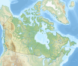
Whitehorse is the capital of the Yukon, and the largest city in Northern Canada. It was incorporated in 1950 and is located at kilometre 1426 on the Alaska Highway in southern Yukon. Whitehorse's downtown and Riverdale areas occupy both shores of the Yukon River, which rises in British Columbia and meets the Bering Sea in Alaska. The city was named after the White Horse Rapids for their resemblance to the mane of a white horse, near Miles Canyon, before the river was dammed.

Yukon is the smallest and westernmost of Canada's three territories. It is the second-least populated province or territory in Canada, with a population of 45,148 as of 2023. However, Whitehorse, the territorial capital, is the largest settlement in any of the three territories.

The Yukon River is a major watercourse of northwestern North America. From its source in British Columbia, Canada, it flows through Canada's territory of Yukon. The lower half of the river continues westward through the U.S. state of Alaska. The river is 3,190 kilometres (1,980 mi) long and empties into the Bering Sea at the Yukon–Kuskokwim Delta. The average flow is 6,400–7,000 m3/s (230,000–250,000 cu ft/s). The total drainage area is 833,000 km2 (321,500 sq mi), of which 323,800 km2 (125,000 sq mi) lies in Canada. The total area is more than 25% larger than Texas or Alberta.
The Alaska Highway was constructed during World War II to connect the contiguous United States to Alaska across Canada. It begins at the junction with several Canadian highways in Dawson Creek, British Columbia, and runs to Delta Junction, Alaska, via Whitehorse, Yukon. When it was completed in 1942, it was about 2,700 kilometres (1,700 mi) long, but in 2012, it was only 2,232 km (1,387 mi). This is due to the realignments of the highway over the years, which has rerouted and straightened many sections. The highway opened to the public in 1948. Once legendary for being a rough, challenging drive, the highway is now paved over its entire length. Its component highways are British Columbia Highway 97, Yukon Highway 1, and Alaska Route 2.

Dawson City, officially the City of Dawson, is a city in the Canadian territory of Yukon. It is inseparably linked to the Klondike Gold Rush (1896–1899). Its population was 1,577 as of the 2021 census, making it the second-largest city in Yukon.

Erik Nielsen Whitehorse International Airport is an airport of entry located in Whitehorse, Yukon, Canada. It is part of the National Airports System, and is owned and operated by the Government of Yukon. The airport was renamed in honour of longtime Yukon Member of Parliament Erik Nielsen on December 15, 2008. The terminal handled 294,000 passengers in 2012, representing a 94% increase in passenger traffic since 2002. By 2017, this number had risen to 366,000. Air North is based in Whitehorse.

Vuntut National Park is a national park located in northern Yukon, Canada. It was established in 1995 as part of the Vuntut Gwitchin First Nation Final Agreement, to conserve, protect and present to Canadians a portion of the North Yukon Natural Region, to recognize Vuntut Gwitchin history and culture, and to protect the traditional and current use of the park by the Vuntut Gwitchin. The name Vuntut comes from the Gwichʼin for among the lakes. Fewer than 25 people visit the park each year.
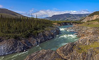
Ivvavik National Park is a national park of Canada located in the Yukon. Initially named "Northern Yukon National Park," the park was renamed Ivvavik in 1992 for the Inuvialuktun word meaning "nursery" or "birthplace," in reference to the importance of the area as a calving ground for Porcupine caribou. Created as a result of the Inuvialuit Final Agreement in 1984, negotiated between the Canadian Government and the Inuvialuit of the Northern Yukon, Ivvavik is the first national park in Canada to be established as a result of an aboriginal land claims agreement. About 100 people visit the park each year.
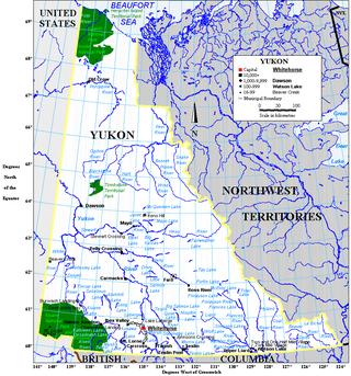
Yukon is in the northwestern corner of Canada and is bordered by Alaska and the Northwest Territories. The sparsely populated territory abounds with natural scenery, snowmelt lakes and perennial white-capped mountains, including many of Canada's highest mountains. The territory's climate is Arctic in territory north of Old Crow, subarctic in the region, between Whitehorse and Old Crow, and humid continental climate south of Whitehorse and in areas close to the British Columbia border. Most of the territory is boreal forest with tundra being the main vegetation zone only in the extreme north and at high elevations.
The Teslin Tlingit Council (TTC) is a First Nation band government in the central Yukon in Canada, located in Teslin, Yukon along the Alaska Highway and Teslin Lake. The language originally spoken by the Teslin Tlingit or Deisleen Ḵwáan is Tlingit. Together with the Taku River Tlingit or Áa Tlein Ḵwáan around Atlin Lake of the Taku River Tlingit First Nation in British Columbia, and carcross tagish first nation or natasaaheeni, they comprise the Inland Tlingit.

Mayo is a village in Yukon, Canada, along the Silver Trail and the Stewart River. It had a population of 200 in 2016. The Yukon Bureau of Statistics estimated a population of 496 in 2019. It is also the home of the First Nation of Na-Cho Nyak Dun, whose primary speak the northern variety of the Tutchone language. Na-Cho Nyäk Dun translates into "big river people."

Alkan Air Ltd. is an airline headquartered in Whitehorse, Yukon, Canada. The company operates seven-day-a-week charter and air ambulance (medevac) services. The Whitehorse and Mayo (seasonal) bases generally focus on wheel and floatplane charter and medevac services in northern and western Canada and Alaska. The Nanaimo, BC base provides charter and medevac services, focused primarily in western Canada, the western United States and Mexico. From 2016 to 2018, Alkan also operated scheduled flights between Erik Nielsen Whitehorse International Airport and Watson Lake Airport.

The Alligator Lake volcanic complex is a group of basaltic cinder cones and lava flows in south central Yukon. The upper part of the Alligator Lake volcanic complex consists of two well-preserved cinder cones capping a small shield volcano. They probably post-date the local Holocene glaciation. Lava flows from both cinder cones traveled to the north and were erupted simultaneously. Their compositions range from alkali olivine basalt to basanitic. Lava flows from the northeast cone are the largest extending 6 km (4 mi) from the cone and expanding to a width of 10 km (6 mi) at the terminus.
Ibex Mountain is a young cinder cone in the Yukon Territory, Canada, located 33 km southwest of Whitehorse and 12 km southeast of Mount Arkell. It is in a group of basaltic cones and lava flows called Alligator Lake and is in the Northern Cordilleran Volcanic Province. It is believed Ibex Mountain last erupted during the Pleistocene. Ibex Mountain is at the head of the Ibex River, which is southeast of Whitehorse. There is a road that runs close to Ibex Lake on the southeast side of the summit. From there is the hike to the summit of the cone.
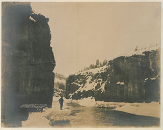
The Miles Canyon Basalts represent a package of rocks that include various exposures of basaltic lava flows and cones that erupted and flowed across an ancient pre-glacial landscape in south-central Yukon.
A designated place (DPL) is a type of community or settlement identified by Statistics Canada that does not meet the criteria used to define municipalities or population centres. DPLs are delineated every 5 years for the Canadian census as the statistical counterparts of incorporated places such as cities, towns, and villages.
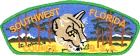
Southwest Florida Council serves Charlotte, Collier, Lee, Manatee, Sarasota and parts of DeSoto and Hendry counties. The Southwest Florida Council was chartered in July 1968, and based on membership and units, it ranks 46th out of 306 councils in the United States. The Southwest Florida Council is a geographic area divided into four districts: Alligator, Manatee, Panther, and Two Rivers. The council has an executive board of volunteers and a staff of professionals.
The COVID-19 pandemic in Yukon is part of an ongoing global pandemic of coronavirus disease 2019 (COVID-19), an infectious disease caused by severe acute respiratory syndrome coronavirus 2 (SARS-CoV-2).