This article includes a list of general references, but it lacks sufficient corresponding inline citations .(February 2013) |
 Almagrundet Lighthouse | |
 | |
| Location | southeast of Sandhamn |
|---|---|
| Coordinates | 59°16′N19°31′E / 59.267°N 19.517°E |
| Tower | |
| Constructed | 1896 (ship first) |
| Construction | concrete tower |
| Automated | 1964 |
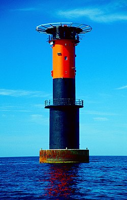
| Height | 30 metres (98 ft) |
| Shape | cylindrical tower with double balcony, lantern and helipad on the top |
| Markings | black tower with a broad red band in the upper part |
| Power source | electricity, solar cell panel |
| Operator | Swedish Maritime Administration [1] |
| Racon | (– – •) |
| Light | |
| First lit | 1964 (current) |
| Focal height | 28 metres (92 ft) |
| Lens | 72 sealbeam lights (1964), Sabik LED 350 (2008) |
| Range | 16 nautical miles (29,632 m) |
| Characteristic | Fl(4) WR 12s (2009–) |
Almagrundet is a Swedish lighthouse station located southeast of Sandhamn outside the Stockholm archipelago and consists of a number of basic heels at depths between 3 and 14 meters below the sea. The shoal was named after the Norwegian brig Alma got aground in heavy storm in 1866 in a place regarded as safe sea.
