Related Research Articles

Woodbridge is a port and market town in the East Suffolk district of Suffolk, England. It is 8 miles (13 km) up the River Deben from the sea. It lies 7 miles (11 km) north-east of Ipswich and forms part of the wider Ipswich built-up area. The town is close to some major archaeological sites of the Anglo-Saxon period, including the Sutton Hoo burial ship, and had 35 households at the time of the Domesday Book of 1086. It is well known for its boating harbour and tide mill, on the edge of the Suffolk Coast and Heath Area of Outstanding Natural Beauty. Several festivals are held. As a "gem in Suffolk's crown", it has been named the best place to live in the East of England.

Herringfleet is a place and former civil parish in the north of the English county of Suffolk. It is located 5.5 miles (8.9 km) north-west of Lowestoft in the East Suffolk district. The parish was combined with Somerleyton and Ashby to create the parish of Somerleyton, Ashby and Herringfleet in 1987.
Minsmere is a place in the English county of Suffolk. It is located on the North Sea coast around 3.5 miles (5.6 km) north of Leiston and 1.5 miles (2.4 km) south-east of Westleton within the Suffolk Coast and Heaths AONB. It is the site of the Minsmere RSPB reserve and the original site of Leiston Abbey.

Blythburgh is a village and civil parish in the East Suffolk district of the English county of Suffolk. It is 4 miles (6.4 km) west of Southwold and 5 miles (8.0 km) south-east of Halesworth and lies on the River Blyth. The A12 road runs through the village which is split either side of the road. At the 2011 census the population of the parish was 297. The parish includes the hamlets of Bulcamp and Hinton.

Corton is a village and civil parish in the north of the English county of Suffolk. It is 3 miles (4.8 km) north of the centre of Lowestoft in the East Suffolk district. The village is on the North Sea coast with the county border with Norfolk to the north. It is a seaside holiday centre, with a number of facilities for visitors. Great Yarmouth is 6 miles (9.7 km) to the north.

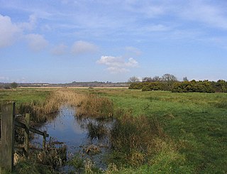
Nacton is a village and civil parish in the East Suffolk district of Suffolk, England. The parish is bounded by the neighbouring parishes of Levington to the east and Bucklesham in the north. It is located between the towns of Ipswich and Felixstowe.

Wissett is a village and civil parish in the English county of Suffolk. It is 2 miles (3.2 km) north-east of the market town of Halesworth in the East Suffolk district. Historically, it was in the Blything Hundred.
Culpho is a hamlet and civil parish in the East Suffolk district of Suffolk, about 4 miles (6.4 km) northeast of the centre of Ipswich and 3+1⁄2 miles (5.6 km) west of Woodbridge.
The Roman Catholic Diocese of East Anglia is a diocese of the Latin Church of the Roman Catholic Church covering the counties of Cambridgeshire, Norfolk, Suffolk, and Peterborough in eastern England. The diocese makes up part of the Catholic Association Pilgrimage.

Barlings Abbey, Lincolnshire, was a Premonstratensian monastery in England, founded in 1154, as a daughter house of the Abbey of St. Mary and St. Martial in Newsham.

Willingham St Mary, also known simply as Willingham, is a village and civil parish in the English county of Suffolk located about 3.5 miles (6 km) south of Beccles in the East Suffolk district. At the 2011 United Kingdom census it had a population of 152.

Ellough is a civil parish in the East Suffolk district of the English county of Suffolk, located approximately 3 miles (5 km) south-east of Beccles. The area is sparsely populated with a mid-2005 population estimate of 40. The parish, which has an area of 4.5 square kilometres (1.7 sq mi), borders Worlingham, North Cove, Mutford, Weston, Sotterley, Willingham St Mary and Henstead with Hulver Street. The parish council operates to administer jointly the parishes of Shadingfield, Willingham St Mary, Sotterley and Ellough.

Weston is a village and civil parish in the English county of Suffolk. It is around 2 miles (3 km) south of Beccles in the East Suffolk district. The parish lies either side of the A145 road and is crossed by the Ipswich to Lowestoft railway line. Neighbouring parishes include Ellough, Ringsfield, Willingham St Mary and Shadingfield. The village is largely dispersed with a population of around 230.

Rumburgh is a village and civil parish in the English county of Suffolk. It is 3.5 miles (5.6 km) north-east of the market town of Halesworth in the East Suffolk District. The population of the parish at the 2011 United Kingdom census was 327.
Blythburgh Priory was a medieval monastic house of Augustinian canons, dedicated to the Blessed Virgin Mary, located in the village of Blythburgh in Suffolk, England. Founded in the early 12th century, it was among the first Augustinian houses in England and began as a cell of St Osyth's Priory in Essex. Although it acquired a conventual life of its own, its community was always small and in some respects maintained dependency upon the parent house. It was earmarked for closure by Cardinal Wolsey during the late 1520s but survived his fall and continued until dissolution in 1536.
Priory of the Holy Trinity was a priory in Ipswich, Suffolk, England. A church of that dedication was named in the Domesday Book, although the building date of the priory was 1177. After a fire, the monastery was rebuilt by John of Oxford, Bishop of Norwich in 1194.

Rumburgh Priory was a Benedictine priory located in the village of Rumburgh in the English county of Suffolk. The priory was founded in about 1065 as a cell of St Benet's Abbey at Hulme in Norfolk. At the time of the Domesday Book in 1086 it had 12 monks. The ownership of the priory was transferred to St Mary's Abbey in York towards the end of the 12th century. The monks of Rumburgh were particularly devoted to St. Bee, whom they commemorated at Michaelmas.
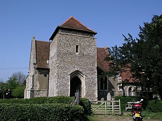
Woodbridge Priory was a small Augustinian priory of canons regular in Woodbridge in the English county of Suffolk. The priory was founded in around 1193 by Ernald Rufus and was dissolved about 1537 during the dissolution of the monasteries. The site was acquired by the Wingfield family before passing to Thomas Seckford in 1564. The priory operated a satellite house at Alnesbourne on the River Orwell until about 1466.

North Cove is a village and civil parish in the north of the English county of Suffolk. It is part of the East Suffolk district, located around 3 miles (4.8 km) east of Beccles and 5 miles (8.0 km) west of Lowestoft. It merges with the village of Barnby and the villages share some resources, although the two parishes retain separate parish councils.
References
- ↑ Wilson.J.M (1872) 'Nacton', Imperial Gazetteer of England and Wales (available online). Retrieved 2011-04-30.
- 1 2 3 Page.W (1975) 'Houses of Austin canons: Priory of Alnesbourn', A History of the County of Suffolk: Volume 2, p. 91 (available online). Retrieved 2011-05-01.
- 1 2 Page.A (1844) 'Alnesbourn Priory', Topographical and Genealogical, The County of Suffolk (available online). Retrieved 2011-05-01.
- 1 2 Page.W (1975) 'Houses of Austin canons: Priory of Woodbridge', A History of the County of Suffolk: Volume 2, pp. 111-112 (available online). Retrieved 2011-05-01.
- ↑ Brabner.J.H.F (ed) (1895) 'Alnesbourne Priory', The Comprehensive Gazetteer of England and Wales, 1894-5 (available online Archived 2011-08-31 at the Wayback Machine ). Retrieved 2011-04-30.
- ↑ Lewis.S (ed) (1848) 'Allostock - Alnwick', A Topographical Dictionary of England, pp. 39-44. (available online). Retrieved 2011-05-01.
- ↑ Alnesbourne Priory Country Club, Nacton, British Listed Buildings. Retrieved 2011-05-01.
- 1 2 Alnesbourn Archived 10 August 2010 at the Wayback Machine , Domesday Map. Retrieved 2011-05-01.
- ↑ "Relationships and changes Alnesbourn Priory ExP/CP through time". A Vision of Britain through Time . Retrieved 18 December 2021.
- ↑ "Population statistics Alnesbourn Priory ExP/CP through time". A Vision of Britain through Time. Retrieved 18 December 2021.