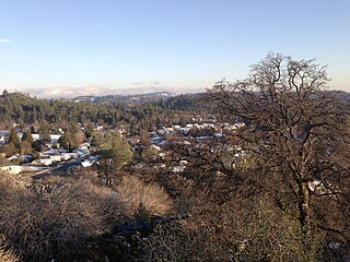
Murphys, originally Murphys New Diggings then Murphy's Camp, is an unincorporated village located in the foothills of the Sierra Nevada mountains in Calaveras County, California, United States. The population was 2,213 at the 2010 census, up from 2,061 at the 2000 census.

Chinese Camp is a census-designated place (CDP) in Tuolumne County, California, United States. The population was 126 at the 2010 census, down from 146 at the 2000 census. It lies in the grassy foothills of the Sierra Nevada near the southern end of California's Gold Country.

Malakoff Diggins State Historic Park is a state park unit preserving Malakoff Diggins, the largest hydraulic mining site in California, United States. The mine was one of several hydraulic mining sites at the center of the 1882 landmark case Woodruff v. North Bloomfield Mining and Gravel Company. The mine pit and several Gold Rush-era buildings are listed on the National Register of Historic Places as the Malakoff Diggins-North Bloomfield Historic District. The "canyon" is 7,000 feet (2,100 m) long, as much as 3,000 feet (910 m) wide, and nearly 600 feet (180 m) deep in places. Visitors can see huge cliffs carved by mighty streams of water, results of the mining technique of washing away entire mountains of gravel to wash out the gold. The park is 26 miles (42 km) north-east of Nevada City, California, in the Gold Rush country. The 3,143-acre (1,272 ha) park was established in 1965.
Alpha and Omega is an appellation of Christ and God in the Book of Revelation.

Dog Town is a gold rush era ghost town in Mono County, California. It is located at 38°10′13″N119°11′51″W, on Dog Creek, near the junction of Clearwater and Virginia Creeks, about 6 miles (10 km) south-southeast of Bridgeport, at an elevation of 7057 feet.

Garlock is an unincorporated community in Kern County, California, United States. It is located 6.25 miles (10 km) east-southeast of Saltdale, at an elevation of 2,169 feet.
You Bet is a small unincorporated community in Nevada County, California. You Bet is located in the Sierra Nevada foothills, 7 miles (11.3 km) east of Grass Valley and 5.5 miles (8.9 km) northeast of Chicago Park.
French Corral is an unincorporated community approximately five miles west of California State Highway 49 in Nevada County, California, United States.

Timbuctoo is an unincorporated community in Yuba County, California. It lies northwest of Smartsville, at an elevation of 397 feet.
The Omega Hydraulic Diggings are located 1 mile (1.6 km) north of what was the town of Omega, California during the California Gold Rush. The site is southeast of the unincorporated town of Washington, California. From SR 20, the diggings are reachable via the gravel Omega Road which merges with Forest Route 29 in small sections.
French Lake, California located in Nevada County, was a California Gold Rush community, now uninhabited. It was located by a lake of the same name.
Gold Hill in Grass Valley, California, was the site of one of the first discoveries of quartz gold in California. While quartz gold was also found in other areas of Nevada County, California during the same time, it is this find near Wolf Creek that led to quartz-mining frenzy and subsequent creation of the Gold Country quartz-mining industry. The location is honored as a California Historical Landmark.

The North Bloomfield Mining and Gravel Company of North Bloomfield, California, was established in 1866 and operated a hydraulic gold-mining operation at the Malakoff Mine subsequent to the California Gold Rush. In its day, no other company's operations matched North Bloomfield Mining and Gravel Company in size or expense. The company operated until 1910. In the years prior, its profits and procedures had been reduced due to the landmark ruling of Woodruff v. North Bloomfield Gravel Mining Company.
Omega was a former settlement in Nevada County, California, United States, first populated in 1850 by a single miner, J.A. Dixon, working a claim during the California Gold Rush. The town was located 3.25 miles (5.2 km) east-southeast of the present-day unincorporated town of Washington, California. A sister town, Alpha, located at what is now the site of the historical Omega Hydraulic Diggings, was about 1 mi (1.6 km) north of Omega. In the mid 1850s, following the introduction of hydraulic mining operations nearby, the town prospered. Omega had a post office, and needed to convert a residence into a jail in late 1858.
Alpha was a gold mining town in Nevada County, located about 2 miles southeast of the town of Washington, California and about 15 miles northeast of Nevada City, California. It lay at an elevation of 4120 feet, about 2 miles below the South Yuba River and just west of Scotchman Creek.
Birchville is a historic mining and agricultural community in Nevada County, California. Birchville is located about 10 miles northwest of Nevada City and about 2 miles northeast of French Corral. It is situated at an elevation of 1,765 ft (538 m) above sea level.

Gold Run was a former mining town of the California Gold Rush, located in Placer County, California.

Michigan Bluff is an unincorporated community in Placer County, California. Michigan Bluff is 4.35 miles (7.0 km) east-northeast of Foresthill. It is at an elevation of 3,510 feet (1,070 m).
Democrat, originally Democrat Hill, is a former settlement in Nevada County, California. It lay on the Chalk Bluff ridge, about 1 mile south of what is now Highway 20, about 6 miles southeast of the town of Washington and about 1 mile east of Remington Hill. Its elevation was 4170 feet. It lay on a gold bearing gravel channel on the Chalk Bluff Ridge, which lies between Steephollow and Greenhorn Creeks, tributaries of the Bear River. As the channel runs southwest, it joins a major channel running from the San Juan Ridge easterly through Red Dog and You Bet into Placer County.

Reading's Bar is a historical site in Redding, California in Shasta County. Reading's Bar is a California Historical Landmark No. 32 listed on August 1, 1932. Reading's Bar was named after Major Pierson Barton Reading, who discovered gold on the Clear Creek bar in May 1848, starting a California Gold Rush in the surrounding area. Later he found gold on a sandbar on the Trinity River that started the Trinity Alps Gold Rush. Reading's gold discovery was a major part of the California Gold Rush and news of the find created a rush of gold prospecting in Northern California, well north of the better-known gold fields of the Sierra Nevada foothills.
