The Arctic Archipelago, also known as the Canadian Arctic Archipelago, is a group of islands north of the Canadian mainland.

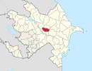
Ujar Rayon is a rayon of Azerbaijan, situated to the south of Goycay, 234 km out of Baku, in the centre of the country. This region contains the Baku-Tbilisi-Ceyhan pipeline to the south of the Shirvan plain.

Ucar is a city and the centre of the Ujar Rayon of Azerbaijan.
Andelfingen District is one of the twelve districts of the German-speaking canton of Zurich, Switzerland.

Szamossályi is a village in Szabolcs-Szatmár-Bereg county, in the Northern Great Plain region of eastern Hungary.

Nagyszekeres is a village in Szabolcs-Szatmár-Bereg county, in the Northern Great Plain region of eastern Hungary.

Ipotești is a commune located in Suceava County, Romania. It is composed of three villages: Ipotești, Lisaura and Tișăuți.
Aşağı Qəsil is a village in the Agdash Rayon of Azerbaijan. The village forms part of the municipality of Qulbəndə.
Kürd is a village in the Goychay Rayon of Azerbaijan. The village forms part of the municipality of Potu.
Ucarlı is a village and municipality in the Kurdamir Rayon of Azerbaijan.
Alpout is a village in the Lachin Rayon of Azerbaijan.
Şordəhnə is a village and municipality in the Agdash Rayon of Azerbaijan. It has a population of 957.
Çayırlı is a village and municipality in the Goychay Rayon of Azerbaijan. The municipality consists of the villages of Çayırlı and Qubadlı Şıxlı.
Sofular is a village and municipality in the Tovuz Rayon of Azerbaijan. It has a population of 443.
Borkana River is a river of central Ethiopia. A tributary of the Awash on the left side, the Borkana joins its parent stream at 10°37′N40°30′E. Johann Ludwig Krapf records that it was called "Tshaffa" by the local Oromo people.

Kács is a village in Borsod-Abaúj-Zemplén County in northeastern Hungary.
Shedegali is a village in Belgaum district of Karnataka, India.

Liotard Glacier is a channel glacier in Antarctica. It is about 3 nautical miles (6 km) wide and 6 nautical miles (11 km) long, and flows north-northeast from the continental ice, terminating in a small ice tongue about 4 nautical miles (7 km) west of Hélène Island. The glacier was delineated from air photos taken by U.S. Navy Operation Highjump, 1946–47, and was named by the Advisory Committee on Antarctic Names for Andre-Frank Liotard, the leader of the French Antarctic Expedition, 1949–51, whose group completed the initial survey of the coastal features as far westward as this glacier.

Buloqboshi is a raion (district) of Andijan Region in Uzbekistan. The capital lies at Buloqboshi. The population is 110,000 people.