Alsace is a cultural region and a territorial collectivity in eastern France, on the west bank of the upper Rhine next to Germany and Switzerland. In January 2021, it had a population of 1,919,745. Alsatian culture is characterized by a blend of German and French influences.
Moselle is the most populous department in Lorraine, in the northeast of France, and is named after the river Moselle, a tributary of the Rhine, which flows through the western part of the department. It had a population of 1,046,543 in 2019. Inhabitants of the department are known as Mosellans.
Meurthe-et-Moselle is a département in the Grand Est region of France, named after the rivers Meurthe and Moselle. Its prefecture and largest city is Nancy and it borders the departments of Meuse to the west, Vosges to the south, Moselle and Bas-Rhin and it borders the Belgian province of Luxembourg and the country of Luxembourg by the canton of Esch-sur-Alzette to the north. It had a population of 733,760 in 2019.

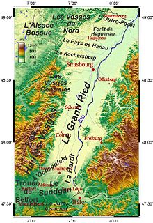
Bas-Rhin is a département in Alsace which is a part of the Grand Est super-region of France. The name means 'Lower Rhine', referring to its lower altitude among the two French Rhine departments: it is downstream of the Haut-Rhin department. Both belong to the European Upper Rhine region. It is, with the Haut-Rhin, one of the two departments of the traditional Alsace region which until 1871, also included the area now known as the Territoire de Belfort. The more populous and densely populated of the pair, it had 1,152,662 inhabitants in 2021. The prefecture is based in Strasbourg. The INSEE and Post Code is 67.

Haut-Rhin is a département in the Grand Est region, France, bordering both Germany and Switzerland. It is named after the river Rhine. Its name means Upper Rhine. Haut-Rhin is the smaller and less populated of the two departments of the former administrative Alsace region, the other being the Bas-Rhin. Especially after the 1871 cession of the southern territory known since 1922 as Territoire de Belfort, although it is still rather densely populated compared to the rest of metropolitan France. It had a population of 767,083 in 2021.

Vosges is a department in the Grand Est region, Northeastern France. It covers part of the Vosges mountain range, after which it is named. Vosges consists of three arrondissements, 17 cantons and 507 communes, including Domrémy-la-Pucelle, where Joan of Arc was born. In 2019, it had a population of 364,499 with an area of 5,874 km2 (2,268 sq mi); its prefecture is Épinal.

The Treaty of Frankfurt was a peace treaty signed in Frankfurt on 10 May 1871, at the end of the Franco-Prussian War.

Alsace–Lorraine, officially the Imperial Territory of Alsace–Lorraine, was a territory of the German Empire, located in modern-day France. It was established in 1871 by the German Empire after it had occupied the region during the Franco-Prussian War. The region was officially ceded to the German Empire in the Treaty of Frankfurt. French resentment about the loss of the territory was one of the contributing factors to World War I. Alsace–Lorraine was formally ceded back to France in 1920 as part of the Treaty of Versailles following Germany's defeat in the war, but already annexed in practice at the war's end in 1918.

Unterelsaß was the northern part of the historical region Alsace or Elsass. From 1871 to 1918, Bezirk Unterelsaß was the name for the central district (Bezirk) of the imperial territory of Elsaß-Lothringen (Alsace-Lorraine) in the German Empire.

La Petite-Pierre is a commune in the Bas-Rhin department in Grand Est in north-eastern France. It lies in the historical and cultural region of Alsace. Petit-Pierre literally means little rock.
Sarrewerden is a commune in the Bas-Rhin department in Grand Est in northeastern France.

Wingen-sur-Moder is a commune in the Bas-Rhin department in Grand Est in north-eastern France. The name, literally translated as "Wingen on the Moder", is often shortened to Wingen, although this is the name of a small commune in the Haguenau-Wissembourg arrondissement.

Lixheim is a commune of France in the northeastern Moselle department of Grand Est, a kilometre southeast of another commune, Vieux-Lixheim.
The département of Bas-Rhin includes 1 urban community and 46 Communities of Communes gathering 517 communes over the 526 of the département. The commune of Siltzheim is part of the agglomeration community Sarreguemines Confluences which is in the département of Moselle.
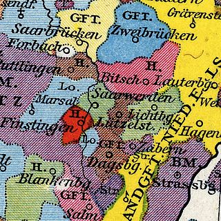
The County of Saarwerden was a county located in Lorraine, within the Holy Roman Empire. As a second-level fief, it belonged to its local ruler and not to the emperor. Its capital was in Bockenheim and later in New Saarwerden or Ville Neuve de Sarrewerden, both in the present city of Sarre-Union. Today, the area of the county belongs to Bas-Rhin, Alsace.

The Pays de Bitche is a natural region in the Moselle department of the Grand Est region of France. It corresponds to the present French part of the former principality of Zweibrücken-Bitsch and to the part of the Northern Vosges that lies within Lorraine.

The region of German Lorraine was the German-speaking part of Lorraine, now in France, that existed for centuries into the 20th century. Following its annexation by France in the 18th century, it became part of the German Empire following the Franco-Prussian War and ceased to exist permanently following Nazi Germany's surrender. The name is also used more specifically to refer to Bezirk Lothringen, the part of Lorraine that belonged to the German Empire from 1871 to 1918 and to Nazi Germany from 1940 to 1945.

Grand Est is an administrative region in northeastern France. It superseded three former administrative regions, Alsace, Champagne-Ardenne and Lorraine, on 1 January 2016 under the provisional name of Alsace-Champagne-Ardenne-Lorraine, as a result of territorial reform which had been passed by the French Parliament in 2014.

The Province of Alsace was an administrative region of the Kingdom of France and one of the many provinces formed in the late 1600s. In 1648, the Landgraviate of Upper-Alsace was absorbed into the Kingdom of France and subsequently became the Province of Alsace, which it remain an integral part of for almost 150 years. In 1790, as a result of the decree dividing France into departments, the province was disestablished and split into three departments: Bas-Rhin, Haut-Rhin, and part of Moselle.
Between the 16th and 18th centuries, Alsace and Lorraine, territories of the Holy Roman Empire located between the Meuse and Rhine rivers, were annexed by the Kingdom of France. Part of these same territories were annexed by the German Empire in the 19th century, then by the Third Reich in the 20th century, before returning to French rule at the end of World War II.