Altavista (Zacatecas)

Last updated
Altavista
Altavista, Chalchihuites, Zacatecas - panoramio.jpg
Altavista archaeological site in Chalchihuites
Location Chalchihuites, Mexico
Region Mesoamerica
Coordinates 23°28′42″N103°56′44″W / 23.47833°N 103.94556°W / 23.47833; -103.94556
TypeArchaeological site
History
Foundedc.200 CE
Abandonedc.1500 CE
CulturesChalchihuites

Altavista, or Chalchihuites, is an archaeological site near the municipality of Chalchihuites in the Mexican state of Zacatecas, in the northwest of Mexico. It is believed that the site was a cultural oasis that was occupied more or less continuously from AD 100 to AD 1400. [1]

Contents

The site is within the "Sierra de Chalchihuites" – from the Nahuatl word chalchíhuitl, the name means "precious stone" – where the Chalchihuites-Chichimec culture was established.

The Altavista name is due to a ranch that existed in the vicinity at the time when archaeologist Manuel Gamio visited the area. There are opinions that this ceremonial center was developed by the Súchil branch of the Chalchihuites culture. [2]

The site is related to the Chalchihuites culture that flourished during the Mesoamerican classical period, which had a social and political structure; had a hieroglyphical writing system; and constructed formal cities and ceremonial centers, as they had urbanization techniques, a numbering system, astronomy, and other important knowledge. These people, known as Chalchihuites, found sufficient elements to favor their social, economic and military life, and thus decided to settle here. [3]

Altavista was a control center for the turquoise trade route, originating in the oasis-American mines of New Mexico. Population decayed towards the year 800 CE, following a disastrous dry spell that ruined farming in the Mexican semi desert.

It is thought that the high point of cultural flourishing at Altavista occurred during years the 400 to 650 CE, that is, in the classical period. The Chalchihuites cultural and ceremonial center represents the maximum northern expansion of Mesoamerica.

This culture spread on the corridor of the eastern flanks of the Sierra Madre Occidental, from west of the State of Zacatecas to Durango, between 100 and 1250 CE, approximately. It is considered a border culture or "culture of transition", according to the archaeologist Manuel Gamio classification of Mesoamerican sedentary groups and hunter-gatherer Chichimec groups that inhabited the arid northern plateau.

Site history

In 1908 Manuel Gamio performed the first scientific excavations in northern Mexico. In Alta Vista he explored the zone now known as the Columns Hall and the annexed stairway; he also made preliminary investigations of the "caverns" in the region, which he considered defensive refuges. [4]

The site was not investigated anymore until 1971, when J. Charles Kelley initiated an extensive excavation of the site. The knowledge of the Chalchihuites site and culture that today is available, is due to the 30 years of studies made by Kelley and associates in the region of the Zacatecas and Durango States. [5]

According to Kelley, the Alta Vista ceremonial center was a designed and built between 450-470 CE. It has been demonstrated that it was not randomly drawn and constructed, but based on a precise location and directions from the Chapín hill, which is a plateau located seven kilometers to the southwest of the ceremonial center where two circle-cross petroglyphs were found, resembling those found at Teotihuacan. From those stone-glyphs, during the summer solstice a sun alignment is projected onto a summit that arises in the Colorado River, known as Picacho Mountain. The Peak, as well, is related to the Labyrinth of the archaeological site of Alta Vista. [1] [5]

The site

Alta Vista is located almost on the Tropic of Cancer and is oriented such that the corners of the main structures coincide with the cardinal points axes; this is not very common in Mesoamerica. [1]

The Chalchihuites investigation works of Phil Weigand, found evidence of more than 750 prehispanic mines; probably the Mesoamerican area with greater mining activity. Also, turquoise imported from distant deposits was found; probably originating from the US southwest, over a thousand kilometers north of Chalchihuites. [1]

Per Kelley investigation, during its apogee, Altavista played a role similar to other Classic period Mesoamerican ceremonial centers, but on a key Chichimec area. This meant that economic activities and local trade existed, exchange of resources with foreign groups at the regional level, from mining exploitation and a political control, which for Chalchihuites included construction and maintenance of religious and civic structures from 450 to 850 CE approximately. [1] [5]

Ceremonial centers such as Alta Vista, with its sophisticated characteristics related to the complex Mesoamerican ritual ideology, are important to understand the nature of the ties that Teotihuacán managed to establish in different parts of Mesoamerica. Traders, priests groups and merchants that managed to integrate the incipient regional elites within trade networks and established routes to maintain these activities; they were, probably one of the integrating forces of the classic Mesoamerica. [1]

Site orientation

The archaeological site was built according to the precise location and orientation of two hills, one is Chapín, seven kilometers southeast, where the two circle-cross petroglyphs were found (similar to those in Teotihuacán). From there the sun alignment on the other hill can be seen, Picacho Pelón, aligned with the Altavista labyrinth, (see below) a hallway limited by adobe walls and embedded pilasters. At the end of the corridor is the Observatory, from which the first equinox sun rays peek over the top of the hill. [1]

The perfect orientation of the civic or main plaza towards the four cardinal points evidences the enormous knowledge possessed by these ancient people of the Astral and magnetic poles. [1]

Another construction, is the "Columns Hall", it has been confirmed that it is a lunar calendar, which consists of four parallel rows of seven columns, which are equivalent to the 28-day lunar cycle. [1]

The archaeological site is located near the Tropic of Cancer and is believed to be one of the main astronomical observatories in Mesoamerica. Its location allows perfect observation the Sun equinoxes and solstices steps in relation to the Sun rising by surrounding hills: Chapín, Pedregoso and Picacho. [1]

Structures

It is apparent that most of the constructions on this site have not yet been explored.

There are two regular size civic plazas, each has a mound in the Center, it is assumed that these were used for human sacrifices, or for people involved in ceremonies or competition. It is worth mentioning, in the east plaza, has more hierarchical spaces, and it leads to believe that these were reserved for regional representatives of native groups, when events took place. [1]

Column Hall

This is the earliest site structure. It is an enclosure with a square base that contains vestiges of a quadrangular chamber with 28 columns that were roof support. The space is divided into four parallel rows of seven columns each, with different sizes and shapes. It is inferred that this was a calendar in which the equivalence of the lunar cycle of 28 days is evident. The hall was constructed over a masonry platform, integrated to a patio with a central altar and an elevated perimeter corridor or walkway. [1]

During excavations it was detected that the structure was carefully laid out, using a lay out post system, that served to fix dimensions to the lines of the inferior and outer walls; these posts were kept and covered with stucco. [1]

It is believed that the original building had an open patio in the center and that in time the structure was modified by adding columns to support a complete roofing system. In a later stage, it was filled up to turn it a platform that supported a superior structure, today has disappeared. [1]

Gamio Stairway

The so-called "Gamio Stairs" were probably an access to the above building. It is noted that several columns seem to have been reinforced; in addition, some reinforcement was added to the outer walls, it is inferred that there were some structural faults in the structure. [1]

A multiple burial was found near the northern lower corner of the structure, including four ceramic vessels as offerings, apparently associated with the four cardinal points. The vessel bodies are decorated with an eagle holding serpents and lightning with its beak and claws. It is inferred that the building was a temple dedicated to the cult of God Tezcatlipoca, the Nocturnal Jaguar God of Northern Skies. [1]

Sun Pyramid

Investigation work in 1976 by Kelley and his team, determined that this pyramid is the last of three constructive stages. On top they found the remains of a temple with battlements. Inside the pyramid is a crypt that contained remains of three individuals with very elaborated offerings, it is believed that they were priest-governors associated to the solar cult. [1] [5]

Skull Temple

It is located southwest of the Sun Pyramid, the adobe walls and floors were stuccoed in repeated occasions. A 70 centimeters small entrance is located in the center of the southeastern wall. Two 40 centimeters diameter floor holes were found that are believed to have served as the foundation for two wood posts which held a roof bracket for ceiling support. In the center is a rock furnace with adobe stucco; it measures, approximately, two square meters. A Concentration of disarticulated human bones was found on the floor of this structure, mainly skulls, jaws and long bones, most of the skulls display perforations in the apex, as well as two leg bones with traces of ropes Mecate (rein) tied in the ends. It has been deduced that the skulls and long bones hung from the ceiling and that they could represent trophies or offerings associated to human sacrifice. [1]

This practice of human sacrifice with ritual exhibition appears in the river basin of Mexico in the Postclassical period (900-1519 CE.) as the Tzompantli architectonic element, it suggests a relation between the mountain groups of this northern region with those of the Mexico central plateau. [1]

Labyrinth

"El Laberinto" El Laberinto.JPG
"El Laberinto"

Located next to the Columns Hall. It is a long corridor with masonry walls; it is made up of a series of returns and pillars with diverse angles. More detailed Inspection showed several additions or corrections that were made throughout the corridor. It has been demonstrated that the eastern extension of the corridor and the summit of the Picacho hill are aligned at the raising of the equinoctial sun. [1]

Apparently the sun on the horizon, behind Picacho, illuminates the labyrinth with a direct light beam; hence it is called the "solar path". The precision used to draw up and build this structure is emphasized, so that it could work as a solar calendar instrument. On one side of the labyrinth is a set of rooms, a hall and an atrium, which is identified as the Astronomers Palace. [1]

Other structures

There are many structures yet to be studied. On a platform southwest of the patio are vestiges of three structures; a central pyramid and small enclosures to both sides.

Site negligence

Chalchihuites population is concerned about the lack of security in the area and safety lacking for the important and valuable collection of archeological pieces housed at the museum. [6]

Related Research Articles

<span class="mw-page-title-main">Cantona (archaeological site)</span>

Cantona is a Mesoamerican archaeological site in Mexico. It is located between 2,450 and 2,600 meters above sea level in the state of Puebla, on the border with the state of Veracruz. The site lies about an hour's drive from the city of Puebla and about an hour and a half from Xalapa, Veracruz. Limited archaeological work has been done at the site. It is estimated that only one to ten per cent of the site can be seen.

AltaVista is search engine company, which is now owned by Yahoo!.

<span class="mw-page-title-main">La Quemada</span>

La Quemada is an archeological site. It is located in the Villanueva Municipality, in the state of Zacatecas, about 56 km south of the city of Zacatecas on Fed 54 Zacatecas–Guadalajara, in Mexico.

<span class="mw-page-title-main">Guachimontones</span> UNESCO World Heritage Site

Los Guachimontones is the largest Late Formative to Classic period pre-Columbian archaeological site in the state of Jalisco. Situated in the hills above the town of Teuchitlán that provides the namesake for the culture that built the site, Los Guachimontones is part of the Agave Landscape and Ancient Industrial Facilities of Tequila UNESCO world heritage site and a major tourist attraction within the Tequila Valleys.

<span class="mw-page-title-main">Chalchihuites Municipality</span> Place in Zacatecas, Mexico

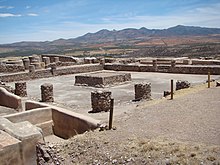
Chalchihuites is a municipality in the Mexican state of Zacatecas in northwest Mexico. The archaeological site of Altavista, at Chalchihuites, is located 137 miles to the northwest of the city of Zacatecas and 102 miles southeast of the city of Durango. Located to the west of Sombrerete in the northwestern corner of the Zacatecas state, it is believed that the site was a cultural oasis that was occupied more or less continuously from AD 100 to AD 1400.

<span class="mw-page-title-main">Peralta (Mesoamerican site)</span> Mesoamerican archaeological site in Abasolo Municipality, Guanajuato, Mexico

Peralta is a prehispanic mesoamerican archaeological site located in Abasolo Municipality, Guanajuato, just outside the village of San Jose de Peralta in the Mexican state of Guanajuato. The site is reached via Fed 90 from Irapuato. Approximately 15.5 km south of the intersection with Fed 45, take the Irapuato-Huanimaro route southeast (left). Follow the route for about 12.5 km, then turnoff southwest (right) to San Jose de Peralta. Cross the bridge and turn right, and then follow the road out of the village northwest about 1 km. The site is on the left.

<span class="mw-page-title-main">Plazuelas</span> Prehispanic archaeological site in Mexico

Plazuelas is a prehispanic archaeological site located just north of San Juan el Alto, some 2.7 kilometers (1.57 mi.) north of federal highway 90 (Pénjamo-Guadalajara), and about 11 kilometers (6.8 mi.) west of the city of Pénjamo in the state of Guanajuato, Mexico. The site is open to the public; it is dominated by a large, rectangular plaza with several pyramidal structures and platforms, along with a massive ball court. To the north of the structures is a field of boulders with thousands of glyphs carved into them.

<span class="mw-page-title-main">Dainzú</span> Zapotec archaeological site in Oaxaca, Mexico

Dainzú is a Zapotec archaeological site located in the eastern side of the Valles Centrales de Oaxaca, about 20 km south-east of the city of Oaxaca, Oaxaca State, Mexico. It is an ancient village near to and contemporary with Monte Albán and Mitla, with an earlier development. Dainzú was first occupied 700-600 BC but the main phase of occupation dates from about 200 BC to 350 AD. The site was excavated in 1965 by Mexican archaeologist Ignacio Bernal.

<span class="mw-page-title-main">Cañada de la Virgen</span>

El Cóporo is a prehispanic archaeological site at the northern frontiers of the Mesoamerican cultural area, located at an elevation of 150 meters on the western slopes of the Santa Bárbara range, near the San José del Torreón community, and lies some 15 kilometres (9 mi) due south of its municipal seat and largest township, on the northwestern corner of Guanajuato state, Mexico.

<span class="mw-page-title-main">Chupícuaro</span>

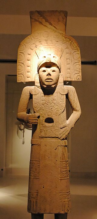
Chupícuaro is an important prehispanic archeological site from the late preclassical or formative period. The culture that takes its name from the site dates to 400 BC to 200 AD, or alternatively 500 BC to 300 AD., although some academics suggest an origin as early as 800 BC.

<span class="mw-page-title-main">Cuahilama</span>

Cuahilama is a Hill and an archaeological site located south east of Santa Cruz Acalpixca, in the Cuahilama neighborhood, near the Xochimilco Archaeological Museum, in Mexico City. It was a ceremonial center, in the hill are prehispanic images engraved in basaltic rock.

<span class="mw-page-title-main">El Chanal</span>

El Chanal is an archaeological site located at El Chanal town, 4 kilometres (2.5 mi) north of the Colima City, Mexico. Based on its extension, over 50 hectares, it is probable that it was the largest settlement of the Colima state; it developed on both banks of the “Río Verde” or Río Colima. This archeological zone is maintained by the people of El Chanal. The area may have been inhabited by native groups around 1300 BC, achieving its maximum splendor between 1100 and 1400 CE. There is a Nahuatl connection shown by archaeological materials representing deities such as Tláloc and Ehécatl.

<span class="mw-page-title-main">El Conde</span>

El Conde is an archeological site located at Ozumba Street, El Conde, three block north the Mayo 1 Ave., in the municipality of Naucalpan, Mexico State.

<span class="mw-page-title-main">El Teúl</span>

El Teúl is an important archaeological Mesoamerican site located on a hill with the same name in the Teúl Municipality in the south of the Zacatecas State, Mexico, near the Jalisco State.

<span class="mw-page-title-main">La Ferrería</span> Archaeological site in Durango, Mexico

La Ferrería is an archaeological site located 7 kilometers south of the City of Durango, in the state of Durango, México, at the “Cerro de La Ferrería”, on the side of the Tunal River.

<span class="mw-page-title-main">Huapalcalco</span> Pre-Columbian Mesoamerican archeological site

Huapalcalco is a pre-Columbian Mesoamerican archeological site located some 5 kilometers north of Tulancingo in the state of Hidalgo, Mexico.

<span class="mw-page-title-main">Las Flores (archaeological site)</span>

Las Flores is an archaeological site pertaining to the Huastec civilization in the city of Tampico, Tamaulipas, in Mexico.

<span class="mw-page-title-main">Ganot-Peschard Museum of Archeology</span> Archaeology museum in Durango, Mexico

The Museo de Arqueología Ganot-Peschard is an archaeology museum located in Zona Centro, Durango, Mexico. The museum plays a major role in preserving the indigenous history of Northern Mexico. The Ganot-Peschard's collection offers archeological materials from the region's landscapes and dwellings including, funeral urns, skulls, vessels, arrowheads, winches, pectorals and other ornamental materials of pre-Hispanic peoples. Its objective is to preserve and spread the archaeological heritage of Durango and the region formed by the states of Zacatecas, Sinaloa, Nayarit and Jalisco.

<span class="mw-page-title-main">El Sabinito</span> Pre-Columbian ruin in Tarnaulipas, Mexico

El Sabinito is a Pre-Columbian ruin associated with the Huastec civilization. Located in the Mexican state of Tamaulipas, El Sabinito is approximately 25 kilometers southwest and 96 kilometers east of the modern-day cities Soto la Marina and Ciudad Victoria. Alongside the Balcon de Montezuma, El Sabinito marks the northernmost boundary of Mesoamerican civilization.

References

  1. 1 2 3 4 5 6 7 8 9 10 11 12 13 14 15 16 17 18 19 20 21 "Página Web de INAH Chalchihuites" [INAH Chalchihuites Official Web Page]. INAH (in Spanish). Mexico. Archived from the original on 2010-09-25. Retrieved 20 October 2010.
  2. "Altavista Zona Arqueológica" [Archaeological Site Altavista] (in Spanish). Chalchihuites, Zacatecas, México. 2008-10-28. Archived from the original on 2011-07-10. Retrieved 20 October 2010.{{cite journal}}: Cite journal requires |journal= (help)
  3. "Articulo Zona Arqueologica Alta Vista, enlace permanente" [Altavista archaeological site, permanent link article] (in Spanish). Aztlan Virtual & INAH. 2007. Archived from the original on 2010-10-15. Retrieved 20 October 2010.
  4. Gamio, Manuel. 1908
  5. 1 2 3 4 Kelley, Charles F. (1971–1976). "Altavista Zona Arqueológica" [Altavista Archaeological Site]. Investigaciones de Chalchihuites (in Spanish). Zacatecas, México.
  6. Valdez, Rubén (June 18, 2010). "Denuncian descuido en museo de Alta Vista, Chalchihuites, Zacatecas" [Negligence denounced in Alta Vista, Chalchihuites, Zacatecas] (in Spanish). Cultura Local: El Sol de Zacatecas. Archived from the original on 9 October 2012. Retrieved 20 October 2010.