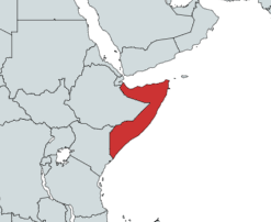
Somalia is a country located in the Horn of Africa which officially consists of the intra-46th meridian east territory, the seven federal member states, namely Galmudug, Hirshabelle, Jubaland, South West, Puntland, and the municipality of Benadir. It is bordered by Ethiopia to the west, the Gulf of Aden to the north, the Somali Sea and Guardafui Channel to the east, and Kenya to the southwest. With a land area of 637,657 square kilometers, Somalia's terrain consists mainly of plateaus, plains and highlands. Its coastline is more than 3,333 kilometers in length, the longest of mainland Africa. It has been described as being roughly shaped "like a tilted number seven".

Cape Guardafui is a headland in the federal state of Puntland in Somalia. Coextensive with Puntland's Gardafuul administrative province, it forms the geographical apex of the Horn of Africa. Its shore at 51°27'52"E is the second easternmost point on mainland Africa after Ras Hafun. The offshore oceanic strait Guardafui Channel is named after it.

Bari is an administrative region (gobol) in northeastern Somalia that consists of six districts: Qandala, Iskushuban, Aluula, Bosaso, Bandarbeyla, and Qardho. The port city of Bosaso is the capital of the region and the largest city in Bari. The region is part of the autonomous Somali state of Puntland.

Puntland, officially the Puntland State of Somalia, is an autonomous territory formed in 1998 that became a federal member state. Puntland is located in the northeastern part of Somalia and its state capital is the city of Garoowe in the Nugal region. The region had a population of 4,334,633 in 2016.

Ras Hafun, also known as Cape Hafun, is a promontory in the northeastern Bari region of the Puntland state in Somalia.
Bargal is a town in the northeastern Bari region of Puntland, Somalia.

Education in Somalia refers to the academic system within Somalia. The Ministry of Education is officially responsible for education in Somalia, with about 15% of the nation's budget allocated to scholastic instruction. The breakaway republic of Somaliland maintains its own advanced Ministry of Education.
Puntland, officially the Puntland State of Somalia, is officially a federal member state in north-eastern Somalia though it is, as of 1 April 2024 A independent state until constitutional changes. The capital of Puntland is Garowe.

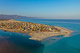
Alula, also spelled Aluula, is a coastal town in the northeastern Ra'as Aseir region and is part of the autonomous state of Puntland, on the coast of the Guardafui Channel. In the late 19th and early 20th centuries, it served as the main capital of the Majeerteen Sultanate. It is ten miles east of Ras Filuk and 100 nautical miles from Bosaso.

The Majeerteen Sultanate, or Majerteen Kingdom also known as Majeerteenia and/or Migiurtinia, was a Somali kingdom centered in the Horn of Africa. Ruled by Boqor Osman Mahamuud during its golden age, the sultanate controlled the areas which are now called Puntland. The earliest mention of the kingdom is the 16th century. The polity had all of the organs of an integrated modern state and maintained a robust trading network. It also entered into treaties with foreign powers and exerted strong centralized authority on the domestic front.

Ra'as Aseir formerly known as Gardafu is a region in north-east of Puntland, Somalia. It is an administrative province of Puntland created in 2013 that was carved out of the Bari Province. It is named after Marinka Gardafu. Most locals work as fisherman along the coast, and it home to the largest date farm in Somalia In the city of geesaley. The province capital is Aluula a coastal town with an extensive mangrove forest. Aluula is also the northernmost point in Somalia.

Deep Depression ARB 01 was the second deadliest tropical cyclone worldwide in 2013 as well as the deadliest to affect Somalia in recorded history. The sixth tropical cyclone and third deep depression of the 2013 North Indian Ocean cyclone season, ARB 01 formed in the Arabian Sea on November 8. The cyclone subsequently strengthened into a deep depression before making landfall in the Puntland region of Somalia at peak intensity on November 11. After making landfall, the cyclone rapidly weakened over land and degenerated into a well-marked low-pressure area later on the same day.
Habo is a small town in the Bari province of the autonomous Puntland region in northeastern Somalia.

Ras Filuk, also known as Cape Elephant, is a headland in the northeastern Bari province of Somalia. It is situated in the autonomous Puntland region.
Gumbah is a populated place in the northeastern Bari region of Somalia. It is part of the Gumbax District.8. Estimated Population is 65,000-exclusively residents. Economic sources of host community. The major source of income are the fishing and frankincense, livestock farming and also small businesses.
Tohen is a settlement in the northeastern Bari province of Somalia. It is situated in the autonomous Puntland region.
Murcanyo, also known as Bander Murcaayo, is a coastal town in the northeastern Bari province of Somalia. It is situated in the autonomous Puntland region
Geesaley, also known as Gesulli, is a coastal town in the northeastern Bari province of Somalia. It is situated in the autonomous Puntland region. Home to the largest date farm in the Horn of Africa.
Bereeda is a coastal town in the northeastern Bari province of Somalia. It is situated in the Alula District, which is in the autonomous Puntland region.

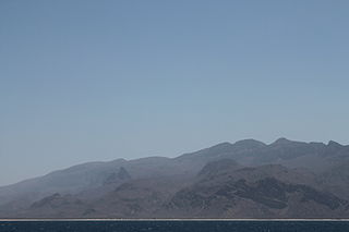
The Guardafui Channel is an oceanic strait off the tip of the Horn of Africa that lies between the Puntland region of Somalia and the Socotra governorate of Yemen to the west of the Arabian Sea. It connects the Gulf of Aden to the north with the Indian Ocean to the south. Its namesake is Cape Guardafui, the very tip of the Horn of Africa. Notable places of interest include the Alula Lagoon.
